Autonomous navigation system and method for UAV based on equipotential surface of electric field in UHV line area

An autonomous navigation system and UHV line technology, which is applied in the field of autonomous navigation system of unmanned aerial vehicles on potential surfaces, can solve the problems of uncontrolled unmanned aerial vehicles, inaccurate sight of human eyes, and easy deviations.

Active Publication Date: 2021-05-11
SHANGHAI UNIV OF ENG SCI
View PDF7 Cites 0 Cited by
  • Summary
  • Abstract
  • Description
  • Claims
  • Application Information

AI Technical Summary

Problems solved by technology

[0003] However, compared with high-voltage and ultra-high-voltage transmission lines, the structure of UHV transmission lines is more complex and the transmission voltage is higher. A strong electromagnetic field is generated around it, which will interfere with circuit components such as drone flight control and measurement modules, and even damage its magnetization, causing the drone to lose control
2) Most of the existing UAV navigation systems use a single satellite navigation method. However, the strong electromagnetic field near the UHV line has great interference to the weak GPS signal, and there are few differential towers in the field. there will be some error
3) When manually controlling the UAV, the human eye's line of sight is not accurate enough and prone to deviation, and accidents are prone to occur when operating in areas with strong electromagnetic fields and complex geographical environments
4) Faced with the situation of crossing rivers and valleys, operators cannot control UAVs for inspection operations under harsh field conditions

Method used


Image

  • Autonomous navigation system and method for UAV based on equipotential surface of electric field in UHV line area
  • Autonomous navigation system and method for UAV based on equipotential surface of electric field in UHV line area
  • Autonomous navigation system and method for UAV based on equipotential surface of electric field in UHV line area

Examples


Embodiment

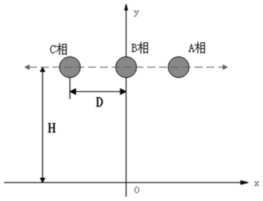
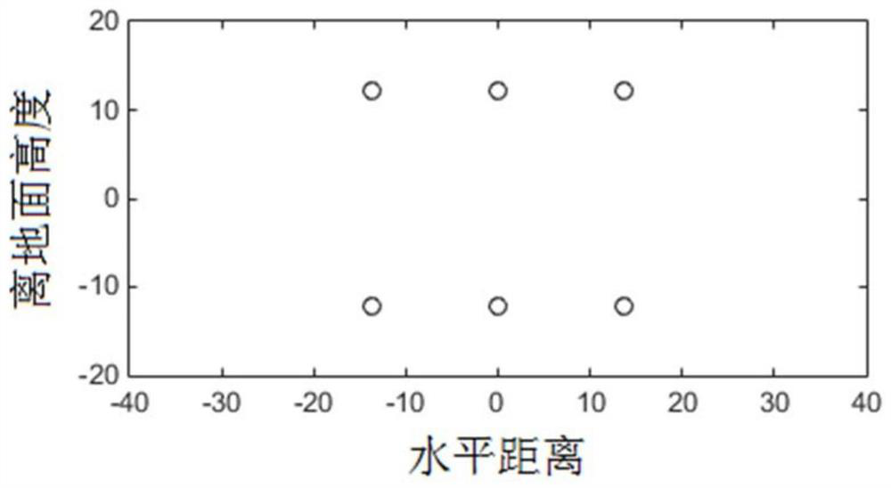
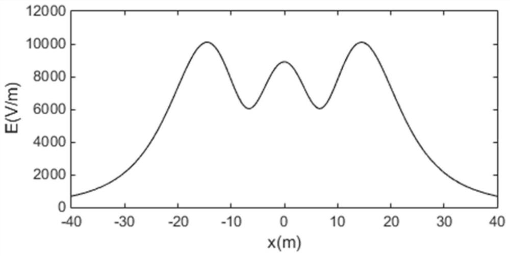
[0045] In this example, the field model experiment of EHV transmission line is carried out. The EHV transmission line in the set model is 500KV. The approximate relationship between the distance between transmission lines (D) and the distance between transmission lines (H) is as follows: figure 1 As shown, phase A, phase B, and phase C respectively represent three-way transmission lines on the tower. The radius of the four split wires is 0.3m, and the radius of the second split wire is 0.0418m. Taking the ground at zero potential and considering the ground as a good conductor, an analog charge can be set at the mirror position of the wire corresponding to the ground, which is equivalent to replacing the influence of the induced charge on the ground.

[0046] Set matching points on the surface of each phase conductor, and solve the following matrix to obtain the simulated charge τ n(m) for:

[0047]

[0048] In the formula, P is the potential system matrix, and the potenti...


PUM


Abstract

The invention relates to a UAV autonomous navigation system and method based on the electric field equipotential surface of the UHV line area. The navigation system is composed of a UAV body, an electromagnetic field measurement module, a flight control subsystem and an inertial navigation subsystem. When the man-machine flies to the initial position, the electromagnetic field measurement module obtains the initial electric field value; the inertial navigation subsystem plans the flight route of the UAV according to the electric field distribution contour map; during the flight, the electromagnetic field measurement module obtains the value of the electric field at the current position; The on-board processing module in the control subsystem judges the difference between the set fluctuation threshold and the initial electric field value according to the flight situation, and sends instructions to the flight control module to adjust the flight height and direction of the UAV; The basis is to fly in depth along the contour of a certain equipotential surface of the contour map. The invention solves the out-of-control problem of the unmanned aerial vehicle caused by the strong electromagnetic field, and has the advantages of autonomous navigation in the environment of UHV transmission lines, stable and accurate navigation, and the like.

Description

technical field [0001] The invention relates to the technical field of autonomous navigation of unmanned aerial vehicles, in particular to an autonomous navigation system and method of unmanned aerial vehicles based on the electric field equipotential surface of an ultra-high voltage line area. Background technique [0002] The inspection work of the UHV power grid is an important part of the operation and maintenance of the UHV power grid project, and it is also a necessary and basic work to ensure the safety of the line. In the long-term operation and maintenance of transmission lines, State Grid has actively applied new technologies to line inspections, among which UAV inspections are a technology that has been widely used in recent years. [0003] However, compared with high-voltage and ultra-high-voltage transmission lines, UHV transmission lines have a more complex structure and higher transmission voltage, and also put forward higher work requirements for UAV inspecti...

Claims


Application Information

Patent Timeline
Patent Type & Authority Patents(China)
IPC IPC(8): G05D1/10G01C21/16
CPCG01C21/165G05D1/101
Inventor 吴飞汪茹贺超田瑾张玉金
Owner SHANGHAI UNIV OF ENG SCI
Why Eureka
Try Eureka