A method for joint retrieval of forest structure parameters from full-waveform LiDAR and hyperspectral data

A laser radar and structural parameter technology, applied in the direction of electromagnetic wave re-radiation, radio wave measurement systems, instruments, etc., can solve the problems of not using full-waveform laser radar data, and comprehensive and in-depth extraction of forest canopy laser radar, etc., to achieve Enhance the ability to describe the spatial structure of the canopy, suppress the high forest coverage, and improve the effect of estimation accuracy

CN109031344BActive Publication Date: 2020-11-10NANJING FORESTRY UNIV
4 Cites 0 Cited by

Patent Information

Authority / Receiving Office
CN · China
Patent Type
Patents(China)
Current Assignee / Owner
Publication Date
2020-11-10

Smart Images

  • Figure 1
    Figure 1
  • Figure 2
    Figure 2
  • Figure 3
    Figure 3
Patent Text Reader

Abstract

The invention discloses a method for jointly inverting forest structure parameters by using a full-waveform lidar and hyperspectral data. Firstly, performing de-noising, smoothing, intensity correction and filtering on airborne full-waveform lidar data, performing interpolation to generate a digital terrain model, and performing high normalization processing on point cloud and waveform data; performing radiation calibration, atmospheric correction and geometric correction preprocessing on a hyperspectral image; then extracting characteristic variables based on normalized point cloud and waveform data and preprocessed hyperspectral data separately; and finally, constructing multivariate regression models combined with ground measured data and the extracted characteristic variables to predict each forest structure parameter. The invention contributes to improving the inversion precision of the forest structure parameters, and effectively suppresses the "saturation" problem of parameter inversion of a stand structure with high forest coverage and high biomass; therefore, the ability and accuracy of forest structure parameter inversion is effectively enhanced; and compared with the stand structure parameter inversion with other similar remote sensing methods, the relative root mean square error is increased by more than 5%.
Need to check novelty before this filing date? Find Prior Art

Description

technical field

[0001] The invention belongs to the technical fields of forest resource monitoring and environmental factor investigation, and relates to a method for jointly inverting forest structure parameters with full-waveform laser radar and hyperspectral data. Background technique

[0002] Accurate extraction of forest structure parameters is of great significance for forest resource monitoring and environmental factor investigation. At the same time, this information can also be used to grasp the relationship between forest plants and the environment, and to further understand the growth and development of forests, which is of great significance for sustainable forest management, ecological model construction and global carbon cycle research. Conventional forest structure parameter extraction mainly relies on field surveys and interpretation of aerial or satellite images, and its accuracy is often not high, and it is difficult to be practically promoted on the "surfa...

Examples

Embodiment 1

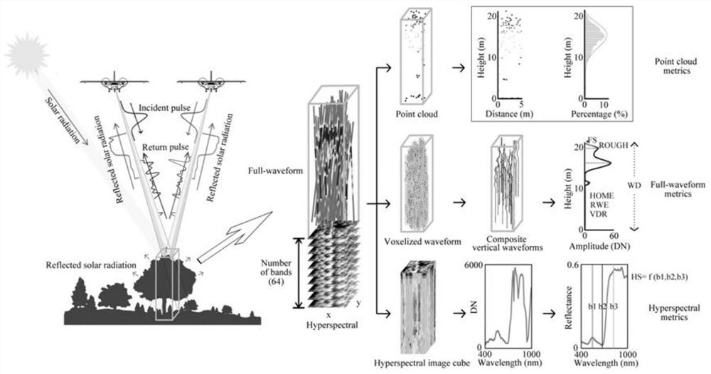
[0037] A method for joint retrieval of forest structure parameters from full-waveform lidar and hyperspectral data, such as figure 1 As shown, the steps are as follows:

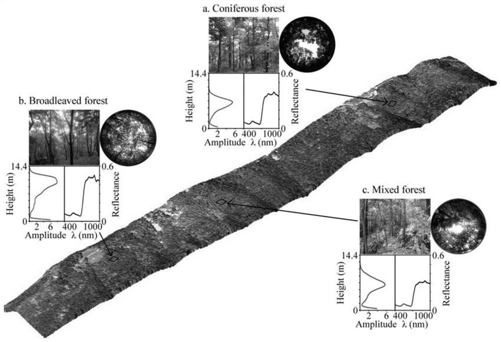
[0038] 1) Set up 67 square plots (30×30m 2 ), with the help of aircraft to collect full-waveform lidar data and hyperspectral image data, such as figure 2 shown. The coordinates of the center point of the sample plot were measured using GPS (Trimble GeoXH6000), which positioned by receiving wide-area differential signals, with an accuracy better than 0.5m. And record and count the tree species in the sample plot, and measure the DBH and tree height of each tree at the same time. The stock volume is estimated according to the unitary volume formula combined with the measured diameter at breast height, and the aboveground biomass is calculated through the allometric growth equation combined with diameter at breast height and tree height. According to the single tree survey data, the aboveground biomass was...