Multi-source heterogeneous data fusion method based on geographic entity

A technology of multi-source heterogeneous data and geographic entities, which is applied in the field of multi-source heterogeneous data fusion based on the structured management of geographic entities, and can solve problems such as the inability to realize custom connection of business data and dynamic connection of IoT-aware information.

Active Publication Date: 2021-07-02
TERRA DIGITAL CREATING SCI & TECH (BEIJING) CO LTD
View PDF15 Cites 19 Cited by
  • Summary
  • Abstract
  • Description
  • Claims
  • Application Information

AI Technical Summary

Problems solved by technology

Use a dynamically expandable semantic template library to realize semantic mapping between multi-source heterogeneous data sources, generate semantic dictionaries, realize semantic cleaning rules can be defined, ensure that text data can be automatically converted semantically between heterogeneous data sources, and realize text data ...

Method used


Image

  • Multi-source heterogeneous data fusion method based on geographic entity

Examples


Embodiment Construction

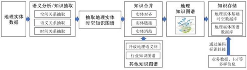
[0030] The technical solutions in the embodiments of the application will be clearly and completely described below with reference to the accompanying drawings and in conjunction with the specific embodiments of the application. Obviously, the described embodiments are exemplary, and the present invention is not limited to the specific embodiments. middle.

[0031]It should be understood that the terms "comprising" and "comprises" in this application indicate the presence of described features, integers, steps, operations, elements and / or components, but do not exclude one or more other features, integers, steps, operations, The presence or addition of elements, components and / or collections thereof. The terminology used in the application is for the purpose of describing particular embodiments only and is not intended to limit the application. As used in this specification and the appended claims, the singular forms "a", "an" and "the" are intended to include plural referent...


PUM


Abstract

The system can realize the functions of semantic search, multi-dimensional query, association analysis, knowledge reasoning and the like of geographic knowledge, can realize service data self-defined hitching and IoT sensing information dynamic hitching in geographic entity structured management, and realizes multi-source heterogeneous data fusion. The multi-source heterogeneous data fusion method for providing scientific decision support for intelligent construction comprises the steps of extracting a geographic entity space-time knowledge graph, and performing knowledge merging on the extracted geographic entity space-time knowledge graph and a plurality of external knowledge graphs to form a complete geographic knowledge graph.

Description

technical field [0001] The invention relates to a multi-source heterogeneous data fusion method, in particular to a multi-source heterogeneous data fusion method based on geographic entity structured management. Background technique [0002] With the development of intelligent cities, digital twins are an effective way of intelligent urbanization, and the construction of a real-scene 3D spatial information platform is the basis for accurate mapping and integration of twin geographical entities in the physical space and information space. The embodiment of structured management informatization level. City Information Modeling (CIM) is a digital expression and description of various physical objects and spatial states above and below ground, indoors and outdoors in a city, which reflects urban planning, construction, development and operation. [0003] The mileage of railways built in my country every year, especially the mileage of high-speed railways, is breaking new record...

Claims


Application Information

Patent Timeline
IPC IPC(8): G06F16/36G06F40/30G06N5/02G06F16/28G06F16/29
CPCG06N5/022G06F16/288G06F16/29G06F16/367G06F40/30
Inventor 刘俊伟王金兰
Owner TERRA DIGITAL CREATING SCI & TECH (BEIJING) CO LTD
Why Eureka
Try Eureka