A Region Control Processing Method Based on Tile Map Data

A technology of tile map and area control, applied in digital data processing, special data processing applications, geographic information databases, etc., can solve problems such as slow transmission efficiency, increased database reading pressure, computational complexity, and potential safety hazards , to achieve the effects of improving processing efficiency, reducing program computational complexity, and high computational efficiency

Active Publication Date: 2021-09-28
吉奥时空信息技术股份有限公司
View PDF0 Cites 0 Cited by
  • Summary
  • Abstract
  • Description
  • Claims
  • Application Information

AI Technical Summary

Problems solved by technology

[0005] There are generally two processing methods in the existing technical solutions. One is to implement in the application terminal, and place a cover graphic in the map container of the terminal as the top layer to achieve the occlusion effect; however, adding a cover layer to the application terminal only Realize visual data coverage, but the actual data is still transmitted to the application terminal through the network, the transmission efficiency is slow, and the purpose of actual data control cannot be achieved, and all data transmission to the application terminal also has certain security risks;
[0006] Another way is through server-side processing, by reading the original data of the boundary polygon of the area, and combining the spatial data contained in the map service for spatial topology processing to obtain the output result; this method does not perform resolution-based boundary data Processing, each processing flow will read the original boundary data from the database, which increases the database reading pressure and computational complexity

Method used


Image

  • A Region Control Processing Method Based on Tile Map Data
  • A Region Control Processing Method Based on Tile Map Data
  • A Region Control Processing Method Based on Tile Map Data

Examples


Embodiment Construction

[0036] In order to make the purpose, technical solution and advantages of the present invention clearer, the embodiments of the present invention will be further described below in conjunction with the accompanying drawings.

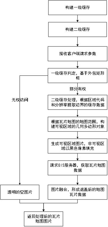
[0037] Please refer to figure 1 , figure 1 It is a flowchart of an area control processing method based on tile map data, including the following steps:

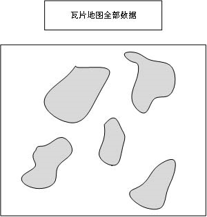
[0038] S101: Cache unit: acquire the tile map image and boundary data, and build a boundary data cache to form a cache boundary;

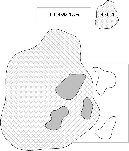
[0039] S102: processing unit: forming a control picture of a visible area according to the cache boundary;

[0040] S103: fusion unit: fuse the control picture and the tile map picture to form a covered picture, and send it to the application terminal for display.

[0041] Cache unit: used for boundary data preprocessing to build a two-level cache mode.

[0042] Level 1 cache: Construct the surrounding rectangular frame Rect of each boundary according to the boundary da...


PUM


Abstract

An area control processing method based on tile map data provided by the present invention includes: a cache unit: acquires a tile map picture and boundary data, and builds a boundary data cache to form a cache boundary; a processing unit: forms a visual cache according to the cache boundary The control picture of the area; the fusion unit: fuse the control picture and the tile map picture to form a covered picture, and send it to the application terminal for display. The cache unit is used for boundary data preprocessing and constructs a two-level cache mode; the processing unit includes two-level processing; the fusion unit outputs the final display picture; the beneficial effect of the present invention is: using the method of the patent of the present invention, the map picture can be directly processed The original GIS service platform does not need to be modified, and it is easy to integrate; based on the two-level cache method, it can quickly identify the covered area in the processing process, and output the map image covered by the area.

Description

technical field [0001] The invention relates to the field of map data processing, in particular to an area control processing method based on tile map data. Background technique [0002] In the context of geographic information system applications, spatial data is often classified according to the source and use of the data to construct feature classes, and the GIS service platform is used to publish it as a map service for external sharing and application. Tile map data is the output result of map service protocols, such as OGCWMS protocol and MapService protocol, all of which have the implementation of the above interfaces, and are relatively mature in the field of WebGIS applications. [0003] A map tile is actually a rectangular image, which contains spatial data within a geographical range, that is, under the GIS coordinate system, the rectangular image has four basic attributes: xmin, ymin, xmax, and ymax. Defined as the Envelope of the map range rectangle. [0004] ...

Claims


Application Information

Patent Timeline
Patent Type & Authority Patents(China)
IPC IPC(8): G06F16/248G06F16/29G06T11/60
CPCG06T11/60G06F16/248G06F16/29
Inventor 李论凌海锋黄宇陈新伟李岚鑫吴威李亚男
Owner 吉奥时空信息技术股份有限公司
Why Eureka
Try Eureka