
Digitizing and mapping the public space using collaborative networks of mobile agents and cloud nodes

a collaborative network and public space technology, applied in road vehicle traffic control, traffic movement detection, instruments, etc., can solve the problems of limited geographic coverage and data update frequency, high cost of conventional systems, and limited geographic coverage of stationary hardwar

Active Publication Date: 2020-03-19
NEXAR LTD
View PDF0 Cites 11 Cited by
  • Summary
  • Abstract
  • Description
  • Claims
  • Application Information

AI Technical Summary

Benefits of technology

The present invention provides a networked system for digitizing public spaces through multiple mobile agents equipped with cameras and sensors connected via a vehicle network. These mobile agents constantly record video, sensor data, and metadata and transmit it to a centralized cloud storage server upon receiving a request from the server. The server analyzes this footage and identifies specific objects and people in the video. It also generates maps and updates them regularly with new camera feeds and weather conditions. This technology allows for real-time monitoring and analysis of public spaces, improving safety and efficiency while reducing human error.

Problems solved by technology

The technical problem addressed in this patent text is the need for improved and affordable systems that can provide high-quality road insights and mapping in real-time. Current systems are expensive, limited in geographical coverage, and data update frequency, making it difficult to provide real-time insights. The goal is to develop a more efficient and effective system that can provide valuable road information to improve safety and efficiency of transportation infrastructures and systems.

Method used


Image

  • Digitizing and mapping the public space using collaborative networks of mobile agents and cloud nodes
  • Digitizing and mapping the public space using collaborative networks of mobile agents and cloud nodes
  • Digitizing and mapping the public space using collaborative networks of mobile agents and cloud nodes

Examples


Embodiment Construction

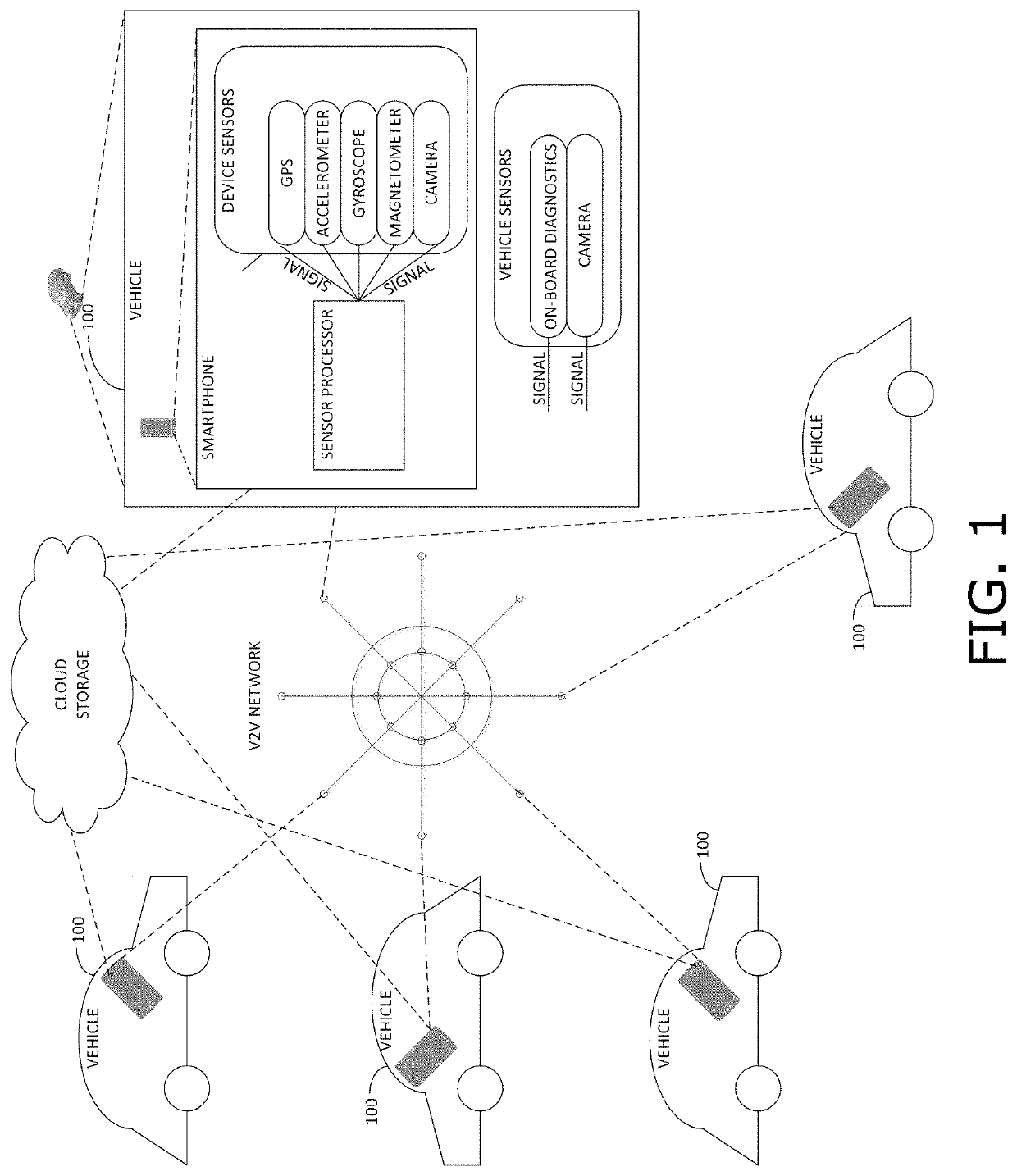
[0028]Proliferation of smartphones and Internet of Things (IoT) devices results in large volumes of data generated at edge devices. Access to actual field data to capture the variety and diversity of real-world situations, improves the software running on the edge devices. However, edge devices are limited in terms of their computational capabilities, to process all of their collected data in depth. In addition, edge device connectivity to the centralized servers with significantly larger computational resource availability is limited. These limitations are more acute when edge devices, such as LiDAR devices and cameras, rely on sensors that generate large volumes of data that communication networks are unable to transfer. Embodiments of the present invention implement a platform to select on-demand, the data to collect and transfer to the cloud.

Overview

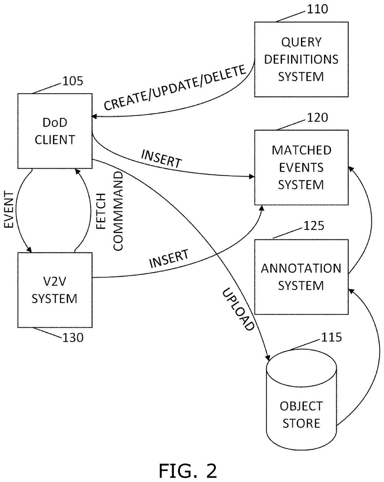
[0029]Reference is made to FIG. 1, which is a simplified diagram of a data-on-demand (DoD) system, in accordance with an embodiment...


PUM


Abstract

A networked system for providing public space data on demand, including a plurality of vehicles driving on city and state roads, each vehicle including an edge device with processing capability that captures frames of its vicinity, a vehicle-to-vehicle network to which the plurality of vehicle are connected, receiving queries for specific types of frame data, propagating the queries to the plurality of vehicles, receiving replies to the queries from a portion of the plurality of vehicles, and delivering matched data by storing the matched data into a centralized storage server, and a learner digitizing the public space in accordance with the received replies to the queries.

Description


Claims


Application Information

Patent Timeline
Owner NEXAR LTD
Learn More