
Method and apparatus for end-to-end travel time estimation using dynamic traffic data

a traffic data and end-to-end technology, applied in the field of transportation networks, can solve the problems of dynamic, state-dependent data that may influence the travel time (e, ) is not accounted, and the computed route may not, in fact, be the best route, etc., to facilitate the identification of the best or fastest rou

Active Publication Date: 2007-06-26
GOOGLE LLC
View PDF8 Cites 56 Cited by
  • Summary
  • Abstract
  • Description
  • Claims
  • Application Information

AI Technical Summary

Benefits of technology

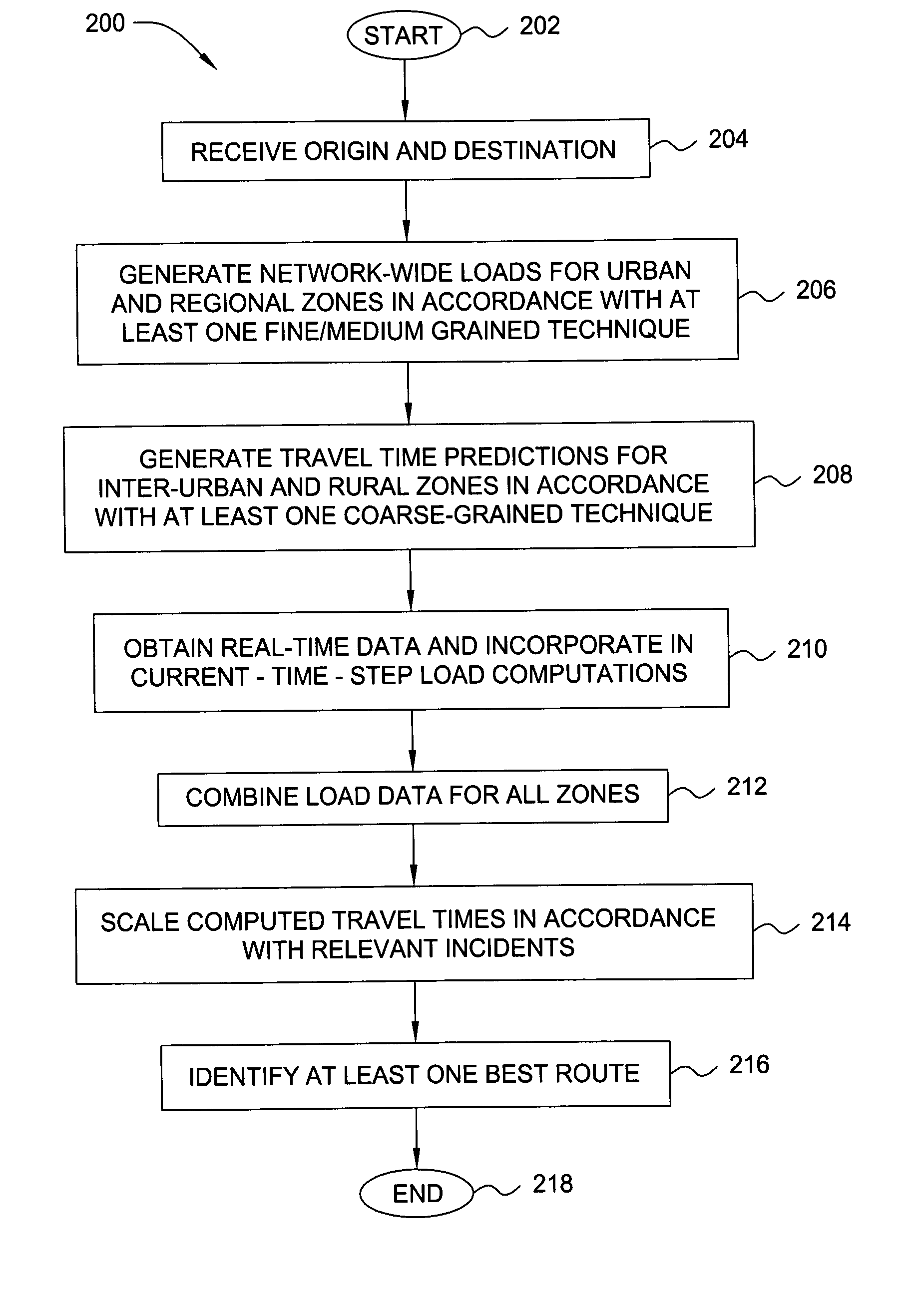
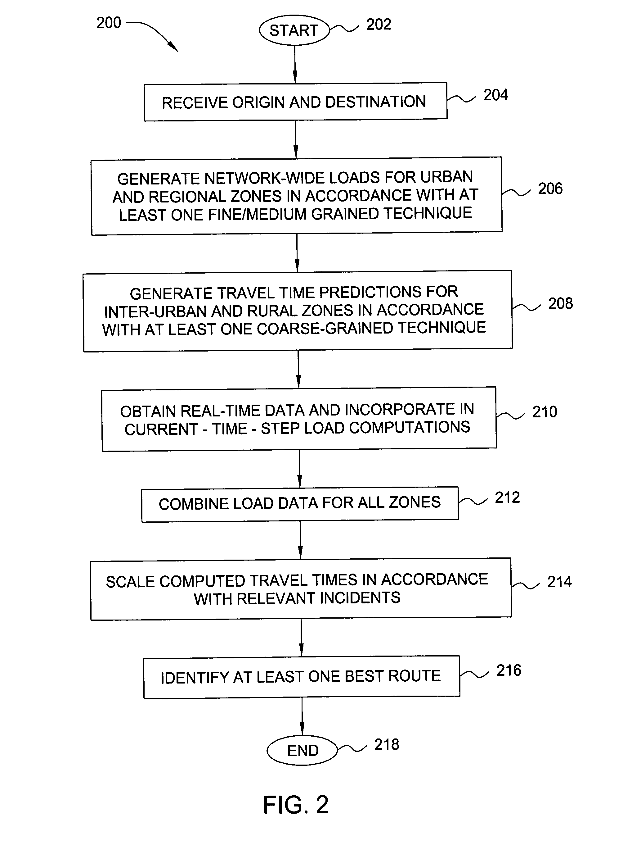
[0006]The present invention is a method and an apparatus for end-to-end travel time estimation using dynamic traffic data. In one embodiment, a method for estimating a fastest route between a first point in a transportation network and a second point in the transportation network includes receiving static data relating to static characteristics of a first zone and a second zone in the transportation network. In addition, real-time data relating to real-time traffic conditions in the first zone is also received. The static and real-time data is processed in accordance with at least one fine-grained load-generation technique to generate a first load for the first zone, and the static data is generated in accordance with at least one coarse-grained load-generation technique to generate a second load for the second zone. These first and second loads are then combined, converted to travel times, and scaled to facilitate the identification of a best or fastest route.

Problems solved by technology

A problem with this approach is that dynamic, state-dependent data that may influence travel time (e.g., current traffic conditions or other environmental factors) is not accounted for.
Thus, a computed route may not, in fact, be the best route at a given time.
Although some methods currently exist that do account for current traffic states, these existing methods are computationally intensive and limited to small or moderately-sized geographic areas.
They are thus difficult to scale to larger, geographically heterogeneous transportation networks (such as the transportation network 100).

Method used


Image

  • Method and apparatus for end-to-end travel time estimation using dynamic traffic data
  • Method and apparatus for end-to-end travel time estimation using dynamic traffic data
  • Method and apparatus for end-to-end travel time estimation using dynamic traffic data

Examples


Embodiment Construction

[0017]In one embodiment, the present invention is a method and apparatus for end-to-end travel time estimation using dynamic traffic data. Embodiments of the present invention account for real-time, state-dependent data in order to provide more accurate end-to-end estimates and predictions (e.g., shortest paths or best routes) for transportation networks, including wide-area, spatially heterogeneous transportation networks. Thus, embodiments of the present invention may be implemented to advantage in applications such as internet mapping, route guidance, in-vehicle or on-board navigation, fleet routing (e.g., for major carriers or the military) and the like.

[0018]As used herein, the terms “shortest path” or “best route” refer to one or more individual links (e.g., road segments) in a transportation network that connect a designated point of origin to a designated destination. Specifically, a shortest path or best route represents the series of links that, if traveled, are expected t...


PUM


Abstract

The present invention is a method and an apparatus for end-to-end travel time estimation using dynamic traffic data. In one embodiment, a method for estimating a fastest route between a first point in a transportation network and a second point in the transportation network includes receiving static data relating to static characteristics of a first zone and a second zone in the transportation network. In addition, real-time data relating to real-time traffic conditions in the first zone is also received. The static and real-time data is processed in accordance with at least one fine-grained load-generation technique to generate a first load for the first zone, and the static data is generated in accordance with at least one coarse-grained load-generation technique to generate a second load for the second zone. These first and second loads are then combined, converted to travel times, and scaled to facilitate the identification of a best or fastest route.

Description

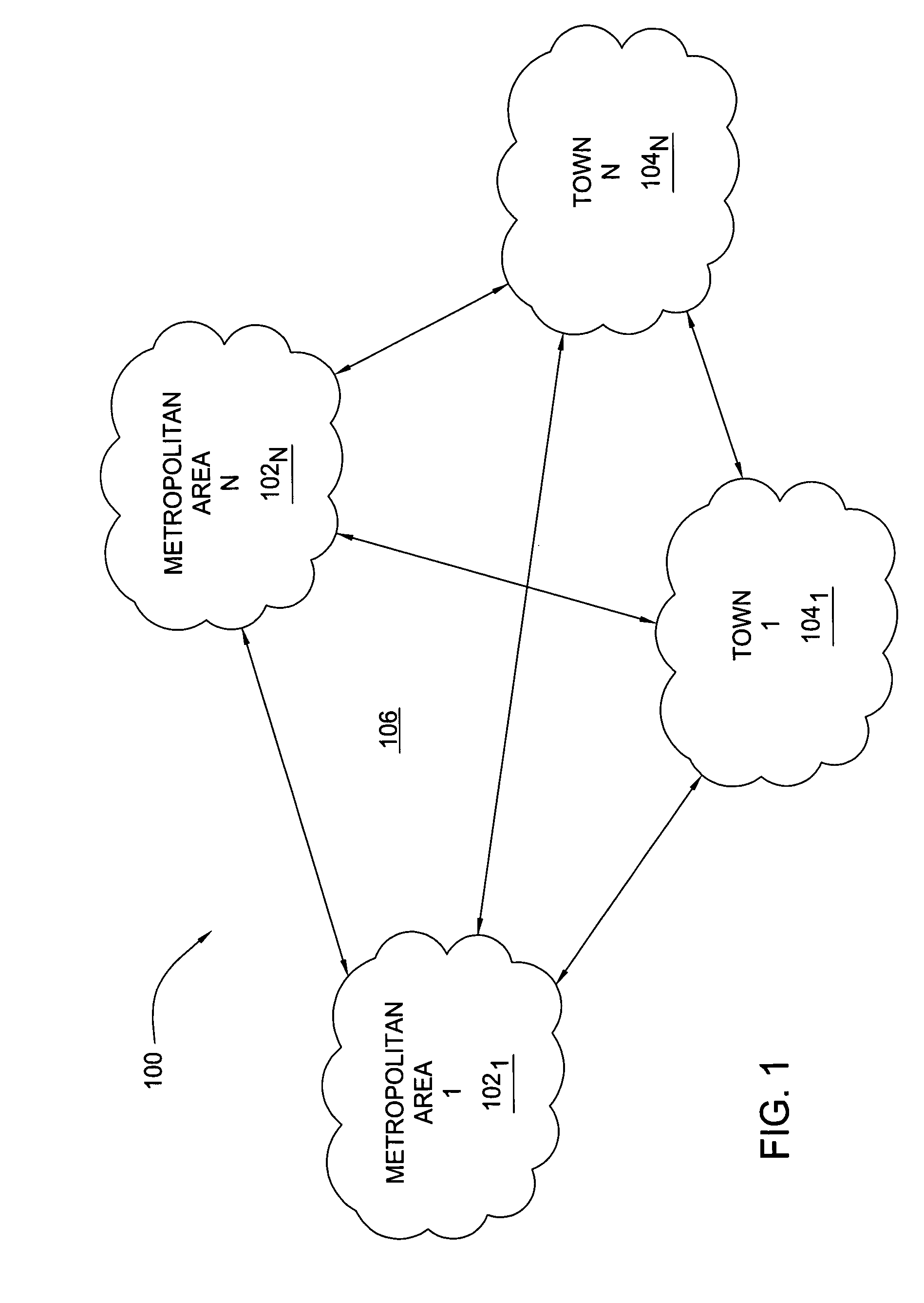
BACKGROUND[0001]The invention relates generally to transportation networks, and relates more particularly to the incorporation of dynamic data in transportation network calculations.[0002]FIG. 1 is a schematic diagram illustrating a typical large-area transportation network 100. The transportation network 100 comprises a plurality of urban metropolitan areas 1021–102N (hereinafter collectively referred to as “metropolitan areas 102), towns 1041–104N (hereinafter collectively referred to as “towns 104”) and inter-urban and / or rural areas (generally designated 106) situated between the metropolitan areas 102 and towns 104. The metropolitan areas 102, towns 104 and inter-urban / rural areas 106 that comprise the transportation network 100 may span a large geographical area (e.g., comprising a plurality of cities, states, regions or countries).[0003]When traveling between locations in a transportation network, it is typically desirable to identify a shortest path, or best (e.g., fastest) ...

Claims


Application Information

Patent Timeline
Patent Type & Authority Patents(United States)
IPC IPC(8): G01C21/34
CPCG01C21/3492
Inventor LIU, ZHENWYNTER, LAURA
Owner GOOGLE LLC
Learn More