System, method and apparatus for searching geographic area using prioritized spatial order

a geographic area and priority technology, applied in the field of search data, can solve the problems of complex and expensive, insufficient processing and memory resources, and inability to search the search area and find the cells in violation, so as to reduce the processing and computation requirements, further processing and calculation savings, and reduce the effect of computation requirements

Inactive Publication Date: 2008-04-22
GARMIN INT
View PDF97 Cites 90 Cited by
  • Summary
  • Abstract
  • Description
  • Claims
  • Application Information

AI Technical Summary

Benefits of technology

[0013]Particular advantages of the present invention are found in significantly reduced processing and computation requirements for system resources employing embodiments of the present invention for use in spatial data searching. By storing a relevant portion of the larger terrain information database in a smaller memory buffer, less data needs to be accessed and dismissed to find relevant data, significantly reducing the calculations needed. By searching the cells of the memory buffer no more than once per alert cycle and in a predetermined prioritized order, the alert list is automatically prioritized and cell data is not searched repeatedly. By searching each memory buffer cell using a single simple comparison, searching the search region only until the alert list reaches a predetermined number of cells, and performing a time-related analysis on the significantly shorter list of cells rather than the entire database, even further processing and calculation savings is achieved as well as providing and displaying relevant alert information to the pilots more quickly.

Problems solved by technology

Searching the search area and finding the cells in violation is expensive in both processor and memory resources.
Both of these methods suffer from the deficiency that they expend precious processor and memory resources.
This requires a determination of whether a cell is within the search area or not, which could be complicated and expensive.
Second, a large data buffer is needed to store the cells found during the search, the dimension of the buffer needed is difficult to determine accurately because the upper bound could equal the size of the search area which varies by the speed of the plane.
Third, sorting the cells in the result buffer by distance to the aircraft position is expensive, especially if a large number of cells are returned in the search and if both distance and bearing are considered.
For the radial search method, some common deficiencies include: First, many possible flight directions are searched, even some of those that are highly unlikely.
This requires expensive processing time to be spent on searching all flight directions even when the aircraft is flying straight.
Second, because the search is performed in a plurality of radial arms originating at the same point and extending in a fan shape over the underlying data sectioned into a square grid, many cells near the origin of the arms are searched numerous times, and some cells farther from the origin are potentially missed if the radial arms become too far apart at their extents.
This is complicated and expensive.
Fourth, a large data buffer is needed to store the cell identities found during the search, and the dimension of the buffer needed is difficult to determine accurately because the upper bound could equal the full number of the search points on all radial arms.
Fifth, in systems which sort the results, sorting the cells in the result buffer by distance to the aircraft position is expensive, especially if a large number of cells is returned in the search and if both distance and bearing are considered.

Method used


Image

  • System, method and apparatus for searching geographic area using prioritized spatial order
  • System, method and apparatus for searching geographic area using prioritized spatial order
  • System, method and apparatus for searching geographic area using prioritized spatial order

Examples


first embodiment

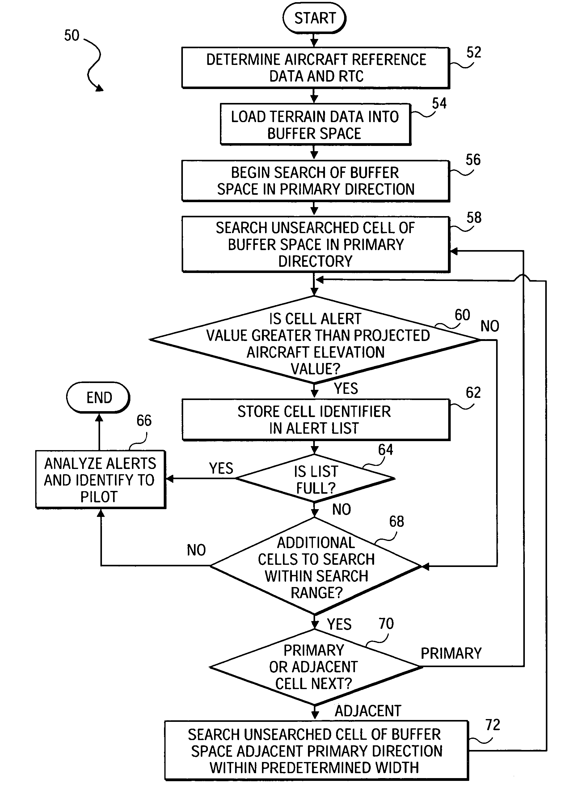
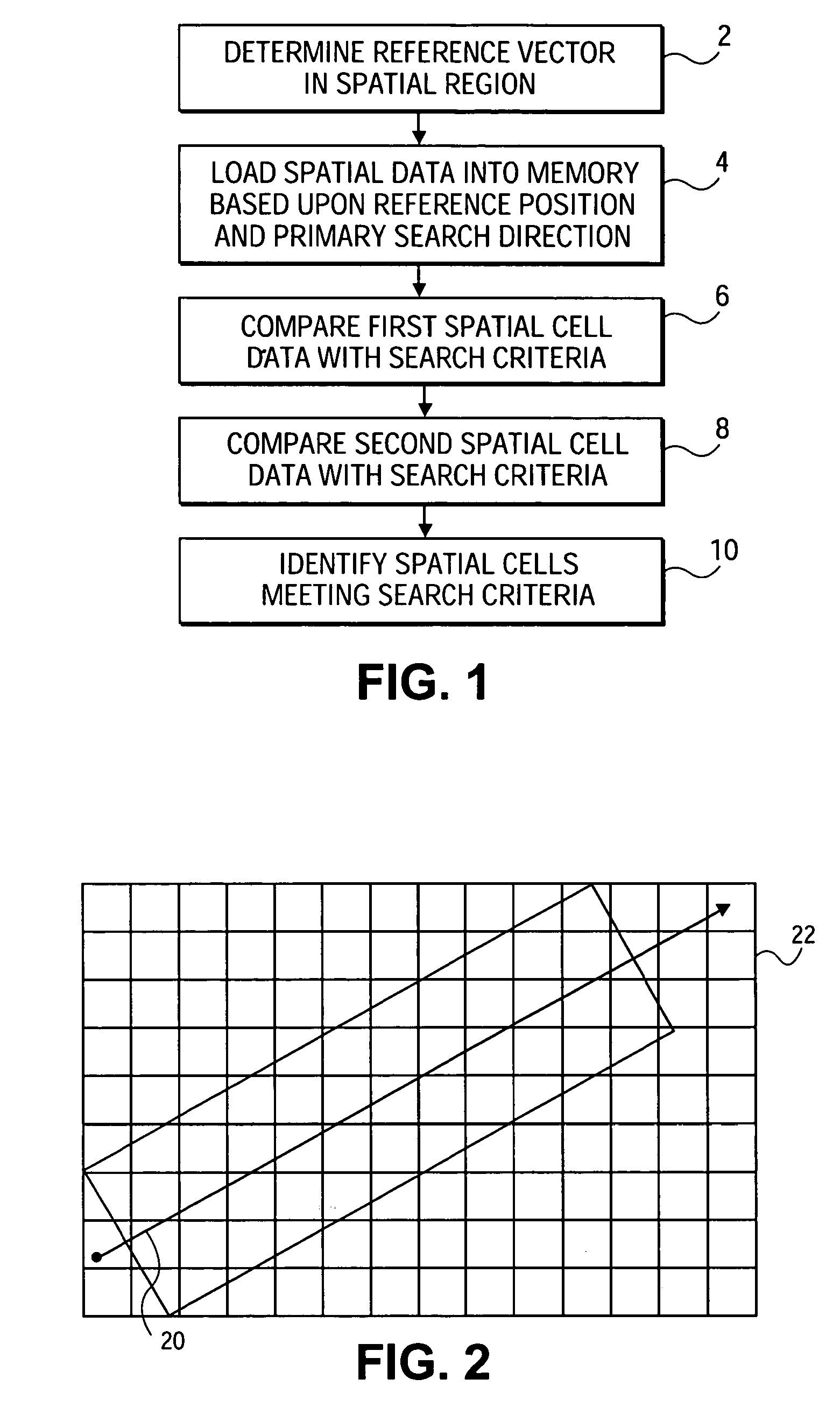
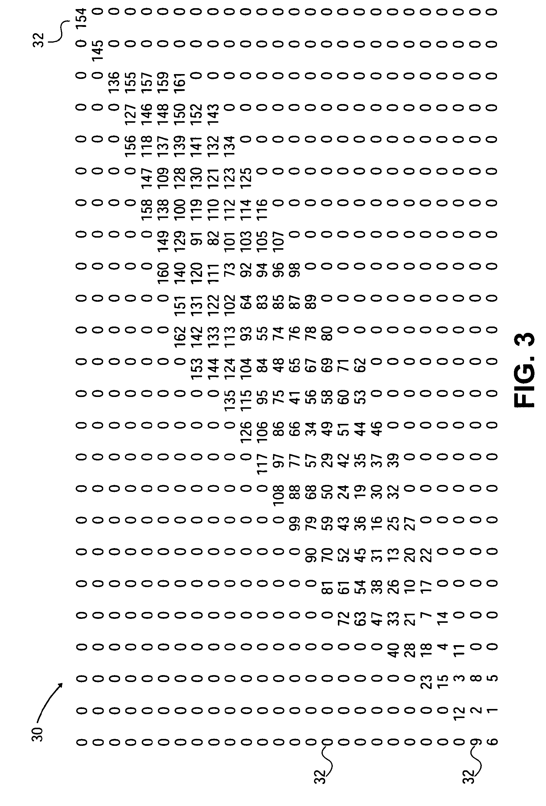
[0028]Referring to FIGS. 1 and 2, a method of searching spatial data in a prioritized manner is shown. The method is useful for searching spatial data from a database including at least one value stored in association with each of a plurality of information records associated with a spatial region. A reference vector 20 within the spatial region 22 is determined (Step 2), and spatial data from a spatial database is accessed which corresponds to a starting point of the search. Spatial data corresponding to the determined spatial region 22 is loaded from the database to a spatial memory buffer based upon the starting reference position and primary search direction of the reference vector 20 (Step 4). By loading a smaller region of relevant data from the spatial information database into a separate memory buffer, the smaller relevant data region may be searched more quickly. In the invention, the smaller region of relevant data is stored in the memory buffer according to its orientatio...

second embodiment

[0054]the further analysis for each cell in the alert list involves a comparison of Ttravel with only one time value as explained below:

[0055]If Ttravelpuw+Trw, a Warning alert is issued for the cell because the time required for the pilot to pull-up to clear the terrain obstacle without additional measures plus the reaction time is greater than the time to travel to the region represented by the cell. If no action is taken, the danger of terrain impact is imminent.

[0056]In this second embodiment of the analysis, some of the cells may be marked as Warning alerts and the remainder of the alert cells will be marked as Caution alerts. Because each of the cells in the alert list were previously indicated as those cells in which the projected altitude of the aircraft is below the clearance elevation boundary, each of the alert cells are marked with an alert. The second embodiment of the analysis, in contrast to the first embodiment, will result in more Caution alerts being issued, but al...


PUM


Abstract

A spatial data search method, system and apparatus for identifying particular data of significance around a reference vector through the spatial data. The method involves determining a reference vector within a spatial region for which spatial data exists, loading a portion of the spatial data including the data around the reference vector into a memory buffer, and searching the spatial data in a prioritized order. The method, system and apparatus have particular utility in searching geographic data for a terrain awareness and warning system (“TAWS”) and display in an aircraft. Embodiments of the present invention provide advantages over existing sequential and radial search methods, significantly reducing the processing and calculations required and providing faster alerts to pilots.

Description

RELATED APPLICATIONS[0001]The present application is a divisional and claims priority benefit of an earlier-filed U.S. patent application entitled “System, Method and Apparatus for Searching Geographic Area Using Prioritized Spatial Order”, Ser. No. 10 / 720,371, filed Nov. 24, 2003, which is a continuation-in-part and claims priority benefit, with regard to all common subject matter, of an earlier-filed U.S. patent application entitled “System, Method and Apparatus for Searching Geographic Area Using Prioritized Spatial Order”, Ser. No. 10 / 337,598, filed Jan. 7, 2003, now U.S. Pat. No. 6,745,115. The above referenced applications are incorporated herein by specific reference.BACKGROUND OF THE INVENTION[0002]1. Technical Field[0003]The present invention generally relates to searching data relating to a spatial region using a prioritized search order, and more particularly to a Terrain Awareness Warning System (“TAWS”) for use by an aircraft for searching terrain elevation data for a g...

Claims


Application Information

Patent Timeline
Patent Type & Authority Patents(United States)
IPC IPC(8): G08G5/04B64D45/04G01C5/00G01C23/00
CPCB64D45/04G01C5/005G01C23/00
Inventor CHEN, SUSAN S.BARBER, CLAYTON E.
Owner GARMIN INT
Why Eureka
Try Eureka