Method for drafting expandable line

A line type and line segment technology, applied in the field of geographic information systems, can solve the problems of only a handful of line types that can be drawn, difficult maintenance, and failure to meet user scalability needs.

Inactive Publication Date: 2009-04-15
WUHAN HONGXIN TELECOMM TECH CO LTD
View PDF0 Cites 7 Cited by
  • Summary
  • Abstract
  • Description
  • Claims
  • Application Information

AI Technical Summary

Problems solved by technology

However, there are only a handful of drawable line types provided by the operating system, which is far from meeting the application needs of geographic information systems.
[0003] If a drawing method is implemented for each line type, it will not only cause maintenance difficulties, but also fail to meet the scalable needs of users

Method used


Image

  • Method for drafting expandable line
  • Method for drafting expandable line

Examples


Embodiment Construction

[0018] Railway is a line type commonly used in maps and has a certain representativeness. Take railway as an example below to illustrate the present invention.

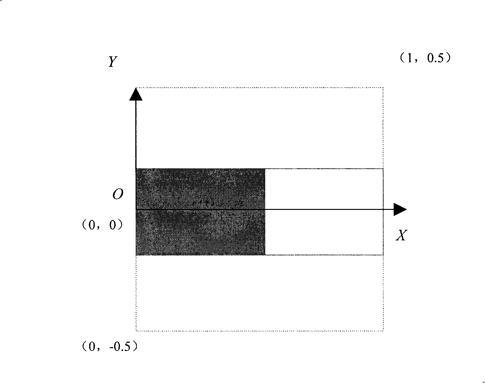
[0019] according to figure 1 , the height and width of each linear unit are unit length, so that the coordinate values ​​are easy to convert in actual drawing, the X-axis direction is the direction of the actual linear features, and the Y-axis direction is the normal direction of the actual linear features . When drawing, multiply the abscissa in the line type unit data coordinate value by the unit length entered by the user to get the abscissa in the device environment, and multiply the ordinate in the line type data coordinate value by the unit width entered by the user to get the device environment The ordinate in the environment.

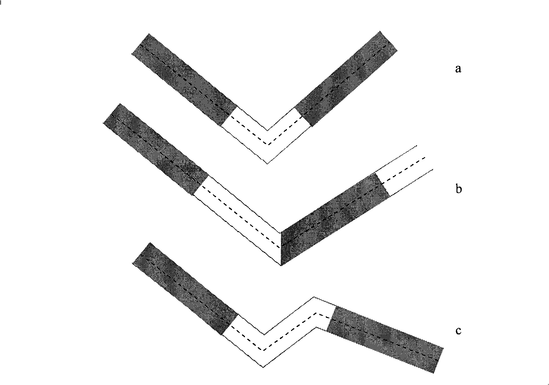
[0020] If a line segment needs to be drawn with a line type, it can be realized by repeatedly drawing the line type unit repeatedly. More complicated is the case of polyline segment...


PUM


Abstract

The invention provides an extensible line type drawing method in a geographic information system and solves the problems of drawing and extension of line shape ground objects. The method divides each line type into single line type unit, and then a coordination system is established for the line type unit; when in actual drawing, each line type unit is drawn along the trending of the line shape ground objects in sequence, and the connection between adjacent line type units is processed, thus realizing the drawing of a line shape ground object completely.

Description

technical field [0001] The invention relates to the field of geographic information systems (GIS), in particular to a method for drawing scalable lines in the geographic information system. Background technique [0002] In the map, linear features such as railways, highways, and city walls are inseparable. In the geographic information system, these linear features need to be displayed in front of the user in an intuitive form, which requires the realization of these linear features in the system. At the same time, geographic information systems often allow users to define extended line types by themselves. However, there are only a handful of drawable line types provided by the operating system, which are far from meeting the application needs of geographic information systems. [0003] If a drawing method is implemented for each line type, it will not only cause maintenance difficulties, but also fail to meet the user's scalability needs. Contents of the invention [0...

Claims


Application Information

Patent Timeline
Patent Type & Authority Applications(China)
IPC IPC(8): G06T11/20
Inventor 章文涛
Owner WUHAN HONGXIN TELECOMM TECH CO LTD
Why Eureka
Try Eureka