Map splicing display method based on a plurality of display terminals

A display terminal and splicing display technology, which is applied in the field of geographic information, can solve problems such as slow display speed, inability to satisfy real-time browsing, and inability to process map operation commands for synchronous splicing display, etc., to achieve the effect of expanding the display size

Inactive Publication Date: 2012-06-13
深圳市大镜科技有限公司
View PDF4 Cites 55 Cited by
  • Summary
  • Abstract
  • Description
  • Claims
  • Application Information

AI Technical Summary

Problems solved by technology

"Although this method solves the problem of wireless splicing of multiple screens, it is only for the split display of multimedia files. For map data with massive data, the display spe

Method used


Image

  • Map splicing display method based on a plurality of display terminals
  • Map splicing display method based on a plurality of display terminals
  • Map splicing display method based on a plurality of display terminals

Examples


Embodiment

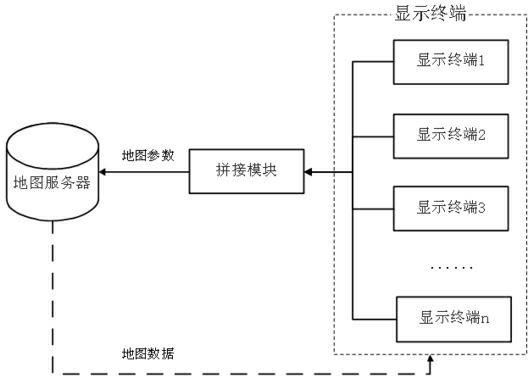
[0037] Such as Figure 5 As shown, in the embodiment of the present invention, the tablet computer 1 and the mobile phone 2 are used as display terminals to perform screen virtual splicing display. Tablet PC 1 and mobile phone 2 are 7 inches and 5 inches in size respectively: Tablet PC 1 is 20 cm long and 12 cm wide, and display screen 4 is 16 cm long and 8 cm wide except frame 3; cell phone 2 is 14 cm long and 8 cm wide, except frame 6 Display screen 5 is long 12cm, wide 6cm. The splicing method is as figure 2 shown.

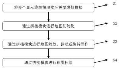
[0038] The steps to implement map mosaic display by these two display terminals are as follows:

[0039] S301: Place the tablet computer 1 and the mobile phone 2 at corresponding physical locations according to actual needs, such as Figure 5 shown;

[0040] S302: Taking the tablet computer 1 as a benchmark reference, establish a virtual coordinate system, set the horizontal direction of the tablet computer 1 as the X axis, set the vertical direction of the...


PUM


Abstract

The invention relates to a map splicing display method based on a plurality of display terminals. The method provided by the invention comprises the following steps of: virtually splicing screens of a plurality of the display terminals; transmitting all display sizes, relative position information and map operation instructions to a splicing module by a plurality of the display terminals; calculating map parameters needed by map display of all the display terminals by the splicing module, and transmitting the map parameters to a map server; generating corresponding map data by the map server according to the map parameters and sending the map data to all the display terminals, so as to assure the synchronous splicing display of the map on a plurality of the display terminals. Therefore, the aim of splicing a plurality of the display terminals with different sizes, different brands and different operation systems is achieved; under the condition of not influencing the display effects of the own screen of each equipment, a display range of the map on a combined screen is enlarged; and furthermore, the same map application can be operated on any one piece of equipment in the combination and results of the operation can keep that all the splicing display terminals can be synchronously displayed.

Description

technical field [0001] The invention relates to the field of geographic information, in particular to a map mosaic display method based on multiple display terminals. Background technique [0002] The map display technology is very mature at present, and the common display terminals used for map display include computers, electronic whiteboards, tablet computers, all-in-one computers, car navigation devices, mobile phones, handheld smart terminals and other equipment. However, the screen size of a single display terminal is relatively limited. When using large-scale map data to display a large-scale spatial area, the size of a single screen often cannot meet the needs of users. Therefore, it is necessary to expand the screen of a single display terminal to meet the needs of users. Larger size screen for map browsing and display needs. The method of expanding the screen size in the prior art is mostly a physical connection method, that is, connecting multiple screens togethe...

Claims


Application Information

Patent Timeline
IPC IPC(8): G06F3/14G09G5/14
Inventor 王飞周泉
Owner 深圳市大镜科技有限公司
Why Eureka
Try Eureka