A method for measuring and evaluating the accuracy of large-area land surface coverage using high-precision instruments

A technology for surface coverage and accuracy evaluation, applied in instruments, measuring devices, etc., can solve the problems of high personnel requirements, difficulty in meeting actual requirements, and no mention of the implementation process, so as to reduce the workload of the field and facilitate management.

Inactive Publication Date: 2017-03-22
JILIN UNIV
View PDF6 Cites 0 Cited by
  • Summary
  • Abstract
  • Description
  • Claims
  • Application Information

AI Technical Summary

Problems solved by technology

[0006] The current land cover methods mainly focus on the evaluation of the classification accuracy of the various object categories of the land cover, and do not pay enough attention to the evaluation of the spatial position accuracy of the various types. With the development of land cover products with high spatial resolution, this qualitative accuracy evaluation method is becoming more and more difficult to meet the actual requirements; Spatial resolution image data is used to verify land cover products, and the method of using high-precision instruments for actual measurement verification and evaluation is rarely involved. Even when performing actual measurement verification work, no clear implementation process is mentioned. Separation, field surveyors have to carry out both field measurement work and in-house accuracy evaluation work. This method of actual measurement implementation has high requirements for personnel, which is not conducive to the development of surface coverage accuracy evaluation in large areas.

Method used


Image

  • A method for measuring and evaluating the accuracy of large-area land surface coverage using high-precision instruments
  • A method for measuring and evaluating the accuracy of large-area land surface coverage using high-precision instruments

Examples


Embodiment Construction

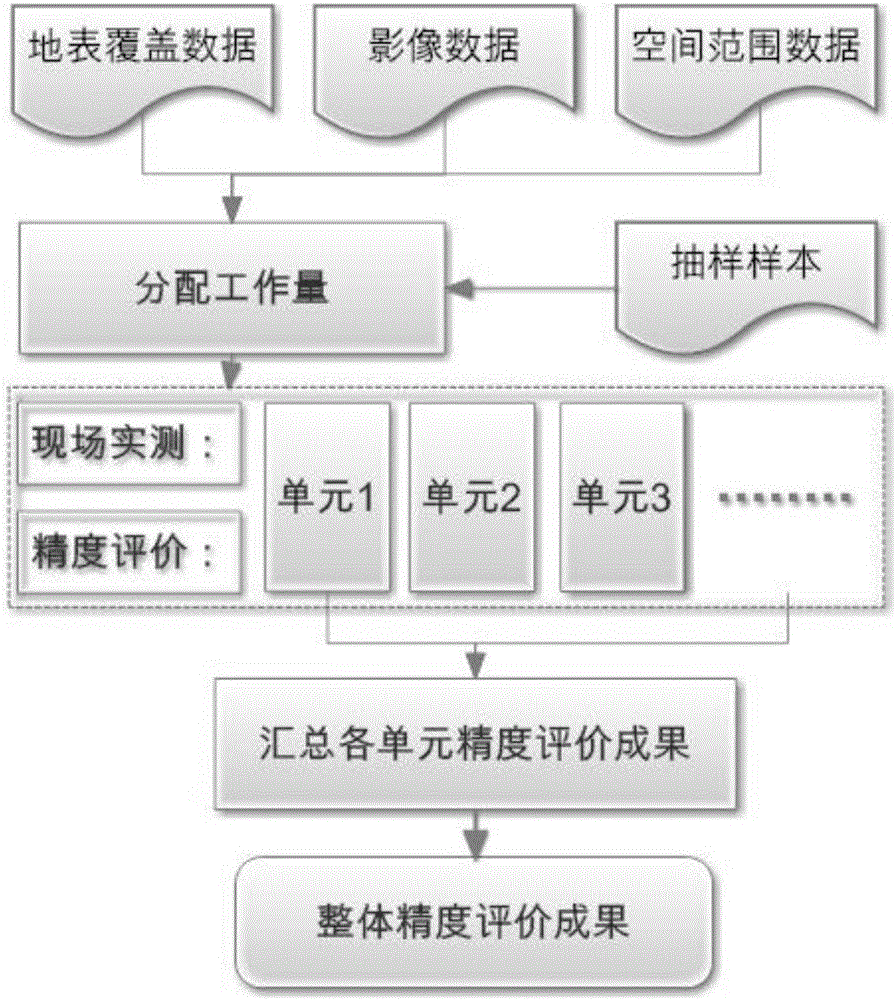
[0018] like Figure 1-2 As shown in , a method for measuring and evaluating the accuracy of large-area land cover using high-precision instruments, in this method, professional surveying and mapping instruments with measurement and positioning functions whose accuracy is at least an order of magnitude higher than that of the land cover product to be evaluated are used. Mapping of a local area.

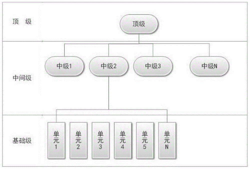
[0019] It includes the following steps: the surface coverage data to be evaluated, the corresponding image data of the surface coverage, the spatial range data that can effectively divide the area in layers, and the comprehensive sampling data of the sampling plan adopted for the accuracy evaluation are divided according to the number of spots and the scope of work. The workload is allocated, and the overall evaluation area is divided into independent units according to the level; high-precision instruments are used for on-site measurement and accuracy evaluation, and then the accuracy...


PUM


Abstract

The invention discloses a method for actually measuring and evaluating large region ground surface coverage precision by using a high-precision instrument. The method comprises the following steps: assigning workload for ground surface coverage data to be evaluated, image data corresponding to ground surface coverage, space range data capable of effectively and hierarchically classifying the region and sampled sample comprehensive data of an adopted precision evaluation sampling scheme according to the number of pattern spots and an operation range, and meanwhile hierarchically dividing the integral evaluation region into each independent unit; performing field actual measurement and precision evaluation by using the high-precision instrument and then summarizing precision evaluation result of each unit to finally form an integral precision evaluation result. By considering the characteristics of qualitative and quantitative precision evaluation, the precision of a region ground surface coverage product is more completely reflected and evaluated; the workload can be hierarchically and clearly cut to facilitate management, so the field work is relieved, and the development of the actual measurement precision evaluation work in a larger range is facilitated.

Description

technical field [0001] The invention relates to the field of land cover evaluation, in particular to a method for measuring and evaluating the accuracy of large-area land cover by using high-precision instruments. Background technique [0002] Land cover refers to the complex of various material types and their natural attributes and characteristics on the earth's surface. Its spatial distribution reflects the process of human social and economic activities and determines the water, heat and material balance of the earth's surface. Its changes directly affect the biogeochemical cycle. , change the moisture, energy and carbon cycle of the land-atmosphere, and cause climate change; land cover data products are usually produced by means of remote sensing mapping, that is, using the rich spectrum, texture features and their temporal and spatial relationships contained in spaceflight and aerial remote sensing images, Combining various reference materials and relevant professional...

Claims


Application Information

Patent Timeline
Patent Type & Authority Patents(China)
IPC IPC(8): G01D21/00
Inventor 刘博宇高秋华
Owner JILIN UNIV
Why Eureka
Try Eureka