Elevated road navigation method and vehicle mounted device

A vehicle-mounted device and technology for elevated roads, applied in the field of map navigation

Inactive Publication Date: 2015-09-09
FAURECIA CLARION ELECTRONICS (XIAMEN) CO LTD
View PDF1 Cites 5 Cited by
  • Summary
  • Abstract
  • Description
  • Claims
  • Application Information

AI Technical Summary

Problems solved by technology

[0003] However, in the above-mentioned prior art, since the vehicle-mounted device requires the vehicle to travel on the elevated road for a long distance or time (in order to form a long enough driving track for analysis), it can determine that the road the vehicle is traveling on is an elevated road. Therefore, there is The following problem: Real-time route navigation cannot be performed for a long distance or time from entering the elevated road

Method used


Image

  • Elevated road navigation method and vehicle mounted device
  • Elevated road navigation method and vehicle mounted device
  • Elevated road navigation method and vehicle mounted device

Examples


Embodiment Construction

[0051] The following will clearly and completely describe the technical solutions in the embodiments of the present invention with reference to the accompanying drawings in the embodiments of the present invention. Obviously, the described embodiments are only some, not all, embodiments of the present invention. Based on the embodiments of the present invention, all other embodiments obtained by persons of ordinary skill in the art without making creative efforts belong to the protection scope of the present invention.

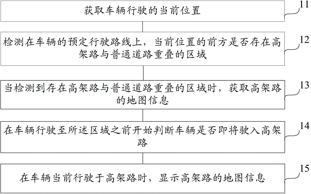
[0052] figure 1 It is a flow chart of the viaduct navigation method provided by Embodiment 1 of the present invention. The method can be implemented by a vehicle-mounted device with a navigation function, and the vehicle-mounted device can be, for example, a vehicle-mounted navigator. Such as figure 1 As shown, the method includes the following steps:

[0053] Step 11. Obtain the current location of the vehicle.

[0054] After the vehicle-mounted device is...


PUM


Abstract

Relating to the map navigation field, the invention provides an elevated road navigation method and a vehicle mounted device to carry out real-time route navigation on elevated road. The vehicle mounted device (30) comprises: a positioning unit (31), which is used for acquiring the current position of vehicle traveling; an overlap area detection unit (32), which is used for detecting on a predetermined travel route of the vehicle, whether an overlap area of an elevated road and a common road exists ahead of the current position; a map information acquisition unit (33), which is used for acquiring the map information of the elevated road when the overlap area detection unit (32) detects the existence of the overlap area of the elevated road and the common road; a processing unit (34), which is used for judging whether the vehicle is about to drive into the elevated road before the vehicle travels to the area; and a display unit (35), which is used for displaying the map information of the elevated road when the processing unit (34) judges that the vehicle is about to drive into the elevated road. The method and the device provided by the invention are applied to elevated road navigation technology.

Description

technical field [0001] The invention relates to the field of map navigation, in particular to an elevated road navigation method and a vehicle-mounted device. Background technique [0002] Japanese Patent Application Laid-Open No. 2007-010545 discloses a vehicle-mounted device for route navigation for vehicles. When the vehicle is driving on an elevated road (or overpass), the vehicle-mounted device first displays a map of ordinary roads, and then analyzes the vehicle's driving trajectory. When the road on which the vehicle is traveling is determined to be an elevated road according to the speed and the like, the displayed map is changed from a map of an ordinary road to a map of an elevated road. [0003] However, in the above-mentioned prior art, since the vehicle-mounted device requires the vehicle to travel on the elevated road for a long distance or time (in order to form a long enough driving track for analysis), it can determine that the road the vehicle is traveling ...

Claims


Application Information

Patent Timeline
Patent Type & Authority Applications(China)
IPC IPC(8): G01C21/26
CPCG01C21/3461
Inventor 朱明张国财
Owner FAURECIA CLARION ELECTRONICS (XIAMEN) CO LTD
Why Eureka
Try Eureka