Satellite-borne laser altimeter on-orbit calibration method and system

A laser altimeter, laser technology, used in radio wave measurement systems, instruments and other directions

Active Publication Date: 2015-11-18
WUHAN UNIV
View PDF6 Cites 22 Cited by
  • Summary
  • Abstract
  • Description
  • Claims
  • Application Information

AI Technical Summary

Problems solved by technology

The requirement of this method for the calibration field is no longer limited to the flat surface, but the surface of nat

Method used


Image

  • Satellite-borne laser altimeter on-orbit calibration method and system
  • Satellite-borne laser altimeter on-orbit calibration method and system
  • Satellite-borne laser altimeter on-orbit calibration method and system

Examples


Embodiment Construction

[0042] In order to make the object, technical solution and advantages of the present invention clearer, the present invention will be further described in detail below in combination with specific implementation cases and with reference to the accompanying drawings.

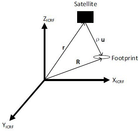
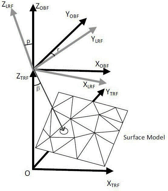
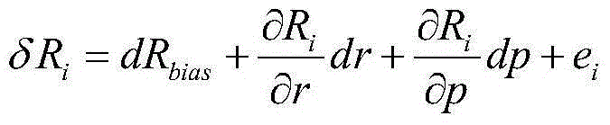
[0043] The invention provides an on-orbit calibration method for space-borne laser altimeter system errors based on the analysis of the residual error of the distance measurement on the surface of natural objects. The natural surface is used as the on-orbit calibration field. The distance residual analysis method is used to perform on-orbit calibration for the systematic errors of the altimetry system, such as assembly errors and ranging errors. During specific implementation, computer software technology can be used to realize the automatic operation process. The embodiment process includes the following steps:

[0044] Step 1. On the premise that the prior model of the surface is known, the ranging model of th...


PUM


Abstract

The invention provides a satellite-borne laser altimeter on-orbit calibration method and system. On the basis of an existing on-orbit calibration method, according to a known earth surface prior model, a distance measuring model of a satellite-borne laser altimeter is built; based on the distance measuring model, a relation between a system error and a distance measuring residual error is established; and an actual measurement distance value and the distance measuring model are utilized to calculate a distance value and generate a distance measuring residual error, and the distance measuring residual error is utilized to realize on-orbit calibration of an assembling error and a distance measuring error in system errors of a height measurement system. The technical scheme of the satellite-borne laser altimeter on-orbit calibration method can well calibrate system errors, thereby avoiding attitude maneuver.

Description

technical field [0001] The present invention relates to the technical field of on-orbit calibration of space-borne laser altimeters, in particular to a technical solution for on-orbit calibration of space-borne laser altimeters based on natural surface ranging residuals, which is used for on-orbit calibration of space-borne laser altimeter systems. track calibration. Background technique [0002] The space-borne laser altimeter is an active measuring device. The laser altimeter with waveform recording and analysis functions collects the original echo waveform of the laser altimeter and extracts the statistical parameters of the waveform. Combined with the altimeter system The parameters and position and attitude information can effectively obtain the height distribution and surface information of the measured target. [0003] The spaceborne laser altimeter is mainly composed of three parts, high-precision attitude determination system, high-precision positioning system and ...

Claims


Application Information

Patent Timeline
IPC IPC(8): G01S7/497
CPCG01S7/497
Inventor 李松易洪杨晋陵周辉郑国兴田昕高俊玲
Owner WUHAN UNIV
Why Eureka
Try Eureka