Geographic background image cutting method and system

A geographic background and image technology, applied in the field of geographic background image processing, can solve problems such as inability to crop, long cropping time, and failure to meet application requirements

Inactive Publication Date: 2016-12-07
BC P INC CHINA NAT PETROLEUM CORP +1
View PDF4 Cites 0 Cited by
  • Summary
  • Abstract
  • Description
  • Claims
  • Application Information

AI Technical Summary

Problems solved by technology

[0006] The existing geographic background map clipping method needs to first load the obtained clipping area pixel data into the memory, which has a great dependence on the memory of the computing device and takes a long time to clip; especially for large geographic background map files, the cropped The size of the background map f

Method used


Image

  • Geographic background image cutting method and system
  • Geographic background image cutting method and system
  • Geographic background image cutting method and system

Examples


Embodiment Construction

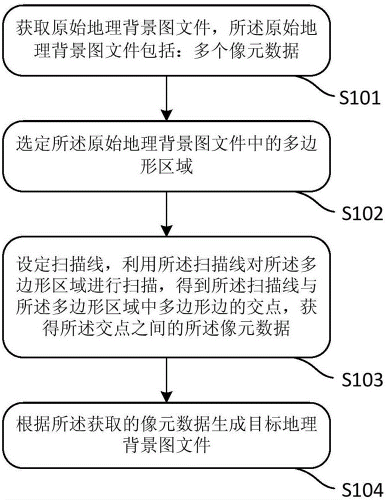
[0086] An embodiment of the present application provides a method for cropping a geographic background image.

[0087]In order to enable those skilled in the art to better understand the technical solutions in the present application, the technical solutions in the embodiments of the present application will be clearly and completely described below in conjunction with the drawings in the embodiments of the present application. Obviously, the described The embodiments are only some of the embodiments of the present application, but not all of them. Based on the embodiments in this application, all other embodiments obtained by persons of ordinary skill in the art without creative efforts shall fall within the scope of protection of this application.

[0088] figure 1 It is a flow chart of an embodiment of a cropping method of a geographic background image in this application. Such as figure 1 As shown, the cropping method of the geographic background image includes:

[008...


PUM


Abstract

The embodiment of the invention discloses a geographic background image cutting method and system. The method comprises the steps that an original geographic background image file is acquired, wherein the original geographic background image file includes multiple pixel element data; the polygonal area in the original geographic background image file is selected; a scanning line is set, and the polygonal area is scanned by using the scanning line so that the intersection points of the scanning line and the polygon edges of the polygonal area are obtained, and the pixel element data between the intersection points are acquired; and a target geographic background image file is generated according to the acquired pixel element data. According to the geographic background image cutting method and system, the cutting speed of the geographic background image can be enhanced.

Description

technical field [0001] The present application relates to the technical field of geographic background image processing in the design of a seismic exploration observation system, in particular to a method and system for cropping a geographic background image. Background technique [0002] 3D seismic exploration technology is a comprehensive application technology integrating physics, mathematics, and computer technology. It can display underground images more clearly and intuitively, and at the same time predict oil layer positions more scientifically. With the continuous increase in the application of 3D seismic prospecting technology, 3D seismic prospecting technology has become an important exploration technology for the exploration of modern oil, natural gas, coal and other underground minerals. In the process of underground mineral exploration using 3D seismic prospecting technology, the design of observation system suitable for 3D seismic prospecting is particularly im...

Claims


Application Information

Patent Timeline
IPC IPC(8): G06T7/00
CPCG06T2207/10032G06T2207/20132G06T2207/30181
Inventor 杜清波李逢春王汉钧郭敏潘英杰于敏杰
Owner BC P INC CHINA NAT PETROLEUM CORP
Why Eureka
Try Eureka