A Massive Spatial Object Storage Method Fused with Encoding and Multi-Version Data
A spatial object and fusion coding technology, which is applied in the field of distributed storage and access of spatial object data, can solve the problems of data redundancy, lack of effective access optimization technology for spatial object data, and no advantages, so as to achieve the effect of improving performance
- Summary
- Abstract
- Description
- Claims
- Application Information
AI Technical Summary
Problems solved by technology
Method used
Image
Examples
Embodiment Construction
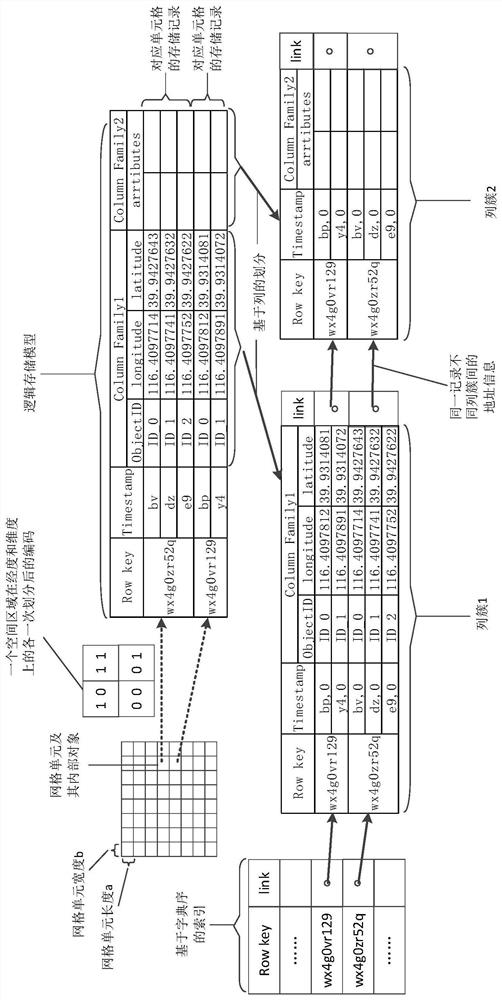
[0020] A massive spatial object storage method that combines encoding and multi-version data, see figure 1 , including the following steps:
[0021] Step 1. Divide the spatial region into grid units of equal size, design a unique code for each grid unit, and let each spatial object be located in and only in one grid unit.
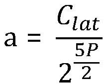
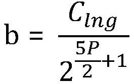
[0022] (1) Take the Base-32 character as the minimum coding unit, set a coding precision P, the size of the grid unit depends on the coding precision P, and the precision P can be adjusted according to the density of the spatial object. Taking the earth as an example, after unfolding it into a planar structure, if the encoding precision is P, the length and width of each grid unit can be expressed as:
[0023]
[0024]
[0025] Among them, C lat Indicates the circumference of the equator, C lng Indicates the polar perimeter.
[0026] (2) Divide the spatial region evenly based on the P value, and encode each region. For example, if the value of P ...
PUM
 Abstract
Description
Claims
Application Information
 - R&D
- Intellectual Property
- Life Sciences
- Materials
- Tech Scout
- Unparalleled Data Quality
- Higher Quality Content
- 60% Fewer Hallucinations
Browse by: Latest US Patents, China's latest patents, Technical Efficacy Thesaurus, Application Domain, Technology Topic, Popular Technical Reports.
© 2025 PatSnap. All rights reserved.Legal|Privacy policy|Modern Slavery Act Transparency Statement|Sitemap|About US| Contact US: help@patsnap.com


