
A method for predicting the fall route of an out-of-control tethered airship

A forecasting method and airship technology, applied in forecasting, measuring devices, radio wave measuring systems, etc., can solve the problems of equipment loss, damage, high price, etc., and achieve the effect of increasing the possibility

Active Publication Date: 2021-04-13
南京俊全科技有限公司
View PDF3 Cites 0 Cited by
  • Summary
  • Abstract
  • Description
  • Claims
  • Application Information

AI Technical Summary

Problems solved by technology

[0004] Since the tethered airship is equipped with a variety of detection equipment, which is expensive and has valuable detection data, once lost, it will cause a lot of losses. However, the existing tethered airship is affected by the weather, wind speed, etc. Unpredictable fall routes and locations, resulting in lost or damaged equipment

Method used


Image

  • A method for predicting the fall route of an out-of-control tethered airship
  • A method for predicting the fall route of an out-of-control tethered airship
  • A method for predicting the fall route of an out-of-control tethered airship

Examples


Embodiment Construction

[0054] Below in conjunction with accompanying drawing, technical scheme of the present invention is described in further detail:

[0055] A method for predicting the fall route of an out-of-control moored airship, comprising the steps of:

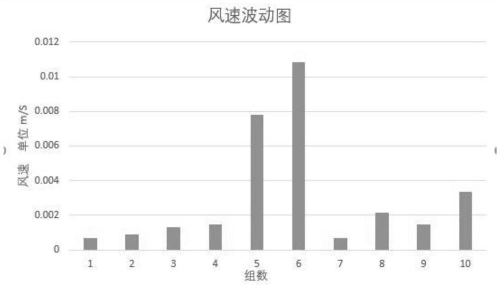
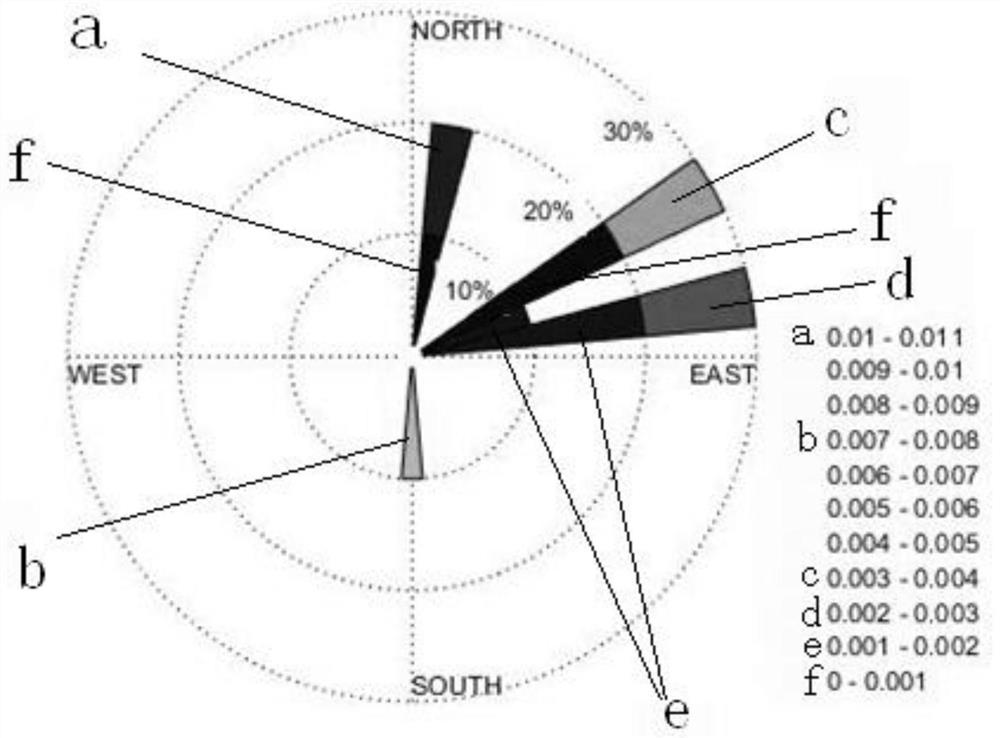
[0056] Step 1: Use the longitude and latitude information returned by the GPS carried on the moored airship out of control, select 11 sets of GPS data in the data set (as shown in Table 1), and calculate the moving distance, speed and moving distance of the moored airship in each time interval. Direction This method is based on the oblate spheroidal coordinates of the earth (wherein the velocity fluctuation of the tethered airship refers to the attached figure 1 ), according to the ellipse equation formed by the coordinates of two adjacent points, the geographical distance between the two points is calculated, and the direction of movement is given; if the direction is true north, it is 0°, and clockwise is positive. This method requires tha...


PUM


Abstract

A method for predicting the fall route of a tethered airship out of control according to the present invention, after the tethered airship is out of control, not only can return the geographical location information of GPS, but also can iteratively calculate and calculate the data according to the existing or real-time GPS data. Update the moving speed and direction of the airship in the air, send the potential flight trajectory of the tethered airship to the ground search personnel in real time, and finally give the probability distribution map of the landing position, which is helpful for the ground search personnel to grasp the dynamics of the position of the out-of-control airship Changes to avoid potential risks to ground personnel and property during landing, and significantly increase the possibility of airship recovery. In the algorithm for estimating the potential trajectory and landing position, this program fully considers the physical characteristics of the airship shape, forced landing deflation rate, and atmospheric boundary layer wind profile, and deeply screens and judges the returned data. Based on the method of probability and statistics, the most Excellent solution.

Description

technical field [0001] The invention relates to a tethered airship, in particular to a method for predicting the fall route of an out-of-control tethered airship. Background technique [0002] Tethered airship (also called tethered balloon) is a carrier used for low-altitude missions. Compared with ordinary hot air balloons and hydrogen balloons, it has a large carrying capacity, good safety, high lift-off height, and wind resistance. Strong and lightning protection capabilities. The general launch altitude is 2000-3500 meters, and it can stay in the air for 15-30 days for a long time. The balloon needs to provide sufficient buoyancy. According to the weight of the carrying equipment, lift-off height, wind resistance and attitude stability requirements, the required air buoyancy is about 1-10 tons. In order to ensure the safety of the equipment on the ball, the ball is filled with a certain pressure of helium. After inflation, the ball is in the shape of an airship, with a...

Claims


Application Information

Patent Timeline
Patent Type & Authority Patents(China)
IPC IPC(8): G06Q10/04G06Q50/26G06F17/18G01S19/42
CPCG01S19/42G06F17/18G06Q10/04G06Q50/26Y02A90/10
Inventor 陈明健李仕俊曹畅汤天然
Owner 南京俊全科技有限公司
Learn More