Regional meteorological radar network data fusion method and device

A weather radar and meteorological data technology, applied in image data processing, instruments, calculations, etc., can solve the problem of inaccurate weather radar mosaic results and achieve accurate mosaic results

Active Publication Date: 2018-06-19
QINGHAI UNIVERSITY +1
View PDF5 Cites 7 Cited by
  • Summary
  • Abstract
  • Description
  • Claims
  • Application Information

AI Technical Summary

Problems solved by technology

[0005] The purpose of the present invention is to provide a method and device for regional weather radar network data fusion, which solves the technical problem of inaccurate weather radar mosaic results obtained by the regional weather radar network data fusion method in the prior art

Method used


Image

  • Regional meteorological radar network data fusion method and device
  • Regional meteorological radar network data fusion method and device
  • Regional meteorological radar network data fusion method and device

Examples


Embodiment 1

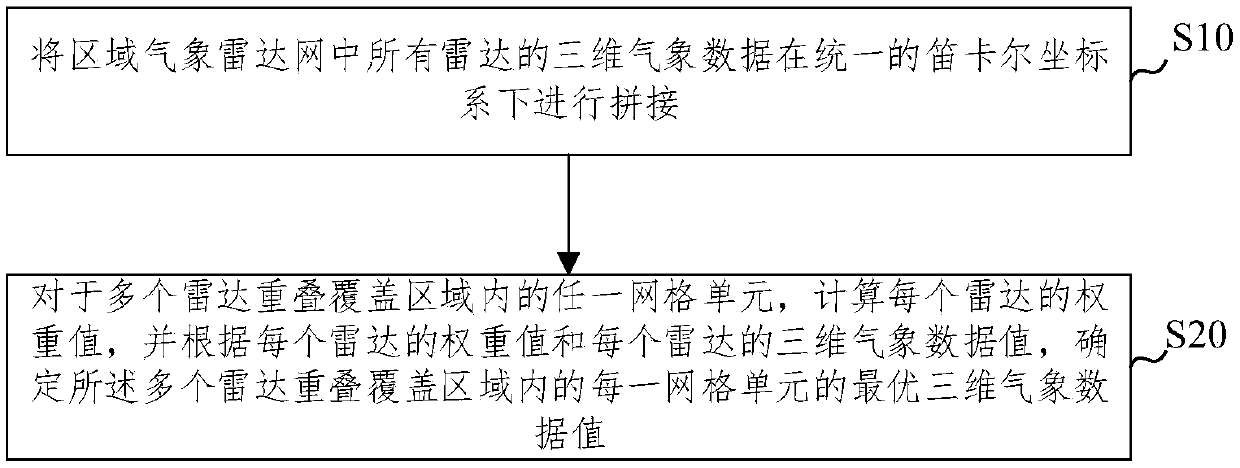
[0038] figure 1 It is a schematic diagram of a regional meteorological radar network data fusion method according to an embodiment of the present invention, such as figure 1 As shown, the embodiment of the present invention provides a kind of regional meteorological radar network data fusion method, comprising:

[0039] Step S10, splicing the three-dimensional meteorological data of all radars in the regional meteorological radar network under a unified Cartesian coordinate system;

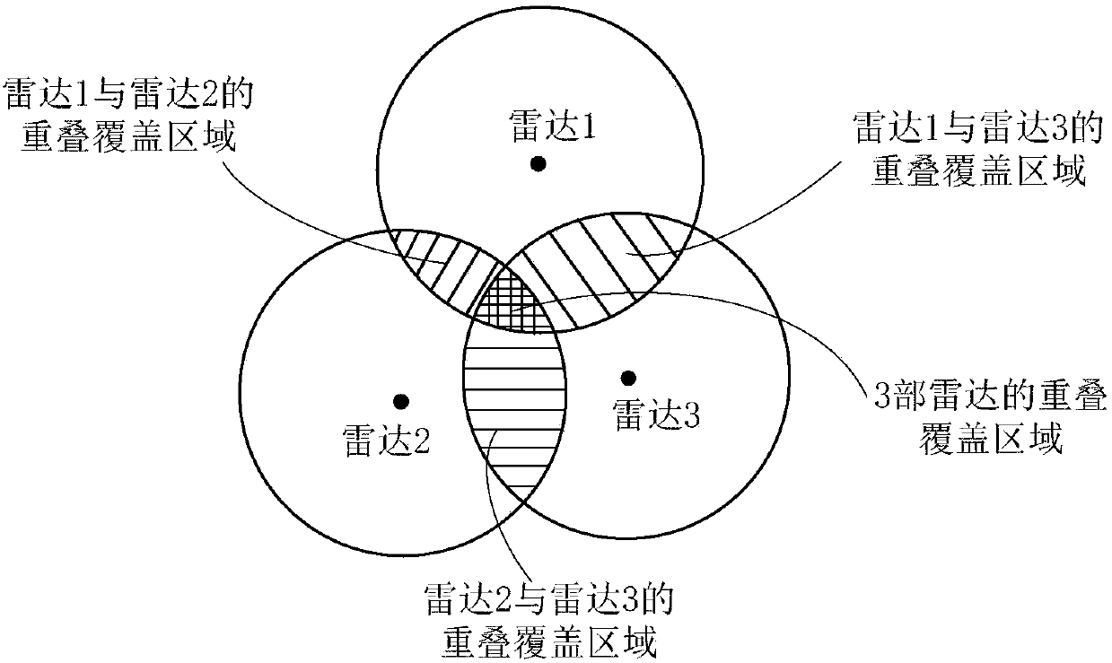
[0040] Step S20, for any grid cell within the overlapping coverage area of ​​multiple radars, calculate the weight value of each radar, and determine the multiple radars according to the weight value of each radar and the three-dimensional meteorological data value of each radar Optimal 3D weather data values ​​for each grid cell within the overlapping coverage area.

[0041] Further, it also includes:

[0042] The three-dimensional weather data of each radar is determined according to the orig...

Embodiment 2

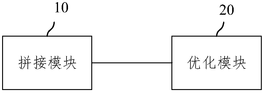
[0074] image 3 It is a schematic diagram of a regional meteorological radar network data fusion device according to an embodiment of the present invention, such as image 3 As shown, the embodiment of the present invention provides a regional meteorological radar network data fusion device, which is used to complete the method described in the above embodiment, specifically including a splicing module 10 and an optimization module 20, wherein,

[0075] The splicing module 10 is used for splicing the three-dimensional meteorological data of all radars in the regional meteorological radar network under a unified Cartesian coordinate system;

[0076] The optimization module 20 is used to calculate the weight value of each radar for any grid cell in the overlapping coverage area of ​​multiple radars, and determine the multiple The optimal 3D meteorological data value of each grid cell within the radar overlapping coverage area.

[0077] The embodiment of the present invention p...

Embodiment 3

[0080] Figure 4 A schematic structural diagram of an electronic device for data fusion of a regional meteorological radar network provided by an embodiment of the present invention, such as Figure 4 As shown, the device includes: a processor 801, a memory 802 and a bus 803;

[0081] Wherein, the processor 801 and the memory 802 complete mutual communication through the bus 803;

[0082] The processor 801 is used to call the program instructions in the memory 802 to execute the methods provided by the above method embodiments, including, for example:

[0083] The three-dimensional meteorological data of all radars in the regional meteorological radar network are stitched together in a unified Cartesian coordinate system;

[0084] For any grid cell in the overlapping coverage area of ​​multiple radars, calculate the weight value of each radar, and determine the overlapping coverage area of ​​the multiple radars according to the weight value of each radar and the three-dimens...


PUM


Abstract

The invention provides a regional meteorological radar network data fusion method and device. According to the method, three-dimensional meteorological data of all the radars in the regional meteorological radar network are spliced in a unified Cartesian coordinate system; for each grid cell in multiple radar overlapped coverage areas, a weight value of each radar is calculated, and the optimal three-dimensional meteorological data of each grid cell in the multiple radar overlapped coverage areas is determined according to the weight value of each radar and the three-dimensional meteorologicaldata of each radar. The method is advantaged in that the meteorological data of the overlapped grid cells are processed according to the radar weight values related to distance and resolution parameters, for the isomorphic radar network as well as the heterogeneous radar network, not only can fine-scale meteorological data characteristics be kept to the maximum degree, but also the continuous space radar mosaic result can be acquired, and the meteorological radar mosaic result is made to be more accurate.

Description

technical field [0001] The invention relates to the technical field of meteorological observation, in particular to a data fusion method and device for a regional meteorological radar network. Background technique [0002] The regional meteorological radar network is composed of multiple meteorological radars distributed in space. By combining, correlating and organizing the meteorological data collected by each radar in the regional meteorological radar network, the meteorological information in a region can be obtained. The meteorological data collected by the radar is in the unit of grid unit, and the coverage areas of different radars partially overlap to ensure the complete meteorological information in an area. Therefore, how to accurately calculate the meteorological data value of the overlapping grid unit, It will have an important impact on the accuracy of the obtained meteorological information. [0003] In the prior art, common methods for calculating meteorologi...

Claims


Application Information

Patent Timeline
Patent Type & Authority Applications(China)
IPC IPC(8): G06T3/40G06T3/60G06T5/50G06T19/20
CPCG06T3/4038G06T3/604G06T5/50G06T19/20
Inventor 黄跃飞魏加华翁燕章李铁键顾声龙谭维贤黄平平
Owner QINGHAI UNIVERSITY
Why Eureka
Try Eureka