River water surface elevation extraction method based on spaceborne interference imaging altimeter

A technology of interferometric imaging and extraction method, which is used in altitude/level measurement, reflection/re-radiation of radio waves, measurement devices, etc., and can solve the problems of sparse distribution of sub-satellite points, limited coverage of inland waters, and narrow swath. To achieve the effect of improving the extraction accuracy

Active Publication Date: 2018-12-11
NAT SPACE SCI CENT CAS
View PDF6 Cites 7 Cited by
  • Summary
  • Abstract
  • Description
  • Claims
  • Application Information

AI Technical Summary

Problems solved by technology

[0003] Due to the narrow swath of the traditional space-borne altimeter (incidence angle of 0°), the distribution of sub-satellite points is sparse, and the coverage of inland waters is limited; and the incidence angle of interferometric synthetic aperture radar (SAR) is generally 20°-60° , the research on river elevation extraction in inland waters is almost blank

Method used


Image

  • River water surface elevation extraction method based on spaceborne interference imaging altimeter
  • River water surface elevation extraction method based on spaceborne interference imaging altimeter
  • River water surface elevation extraction method based on spaceborne interference imaging altimeter

Examples


Embodiment Construction

[0045] The present invention will be described in detail below with reference to the drawings and specific embodiments.

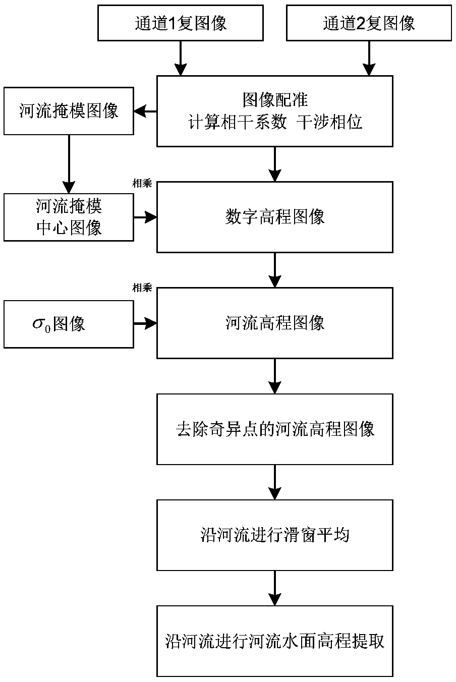
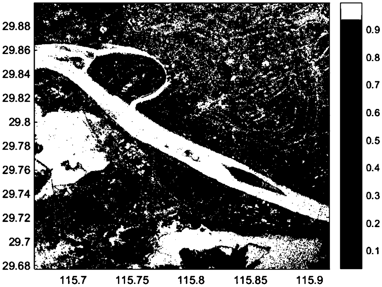
[0046] The invention provides a method for extracting river water surface elevation based on observation data of a small incident angle and short baseline spaceborne interferometric imaging altimeter. The data in this example is the dual-channel data of the Tiangong-2 interferometric imaging altimeter. The date of acquisition is December 2017. The data includes a part of the Yangtze River in Jiangxi Province (East longitude 115.68°-115.90°E and North latitude 29.68°-29.88°N) . The Yangtze River is the longest river in China and the third longest river in the world. It originated from the Tanggula Mountains in Qinghai Province in western China. It flows from west to east through 11 provinces and cities, and finally merges into the East China Sea (Shanghai). Please see the research area figure 1 . The implementation steps are further elaborated below in conjunc...


PUM


Abstract

The invention discloses a river surface elevation extraction method based on a spaceborne interference imaging altimeter. The method comprises the following steps: 1) extracting a binary image of a river mask based on a two-channel coherence coefficient image; 2) extracting the central area of the binary image of the river mask along the river to obtain the center image of the river mask; step 3)processing the interference phase of a two-channel complex image, inverting to obtain a digital elevation model image, and multiplying by the center image of the river mask to obtain a river elevationimage; 4) eliminating the singular points in a river height observation value of the river elevation image, and then performing sliding window averaging of the river height observation value along the river to obtain a smoothed river elevation image; 5) extracting an elevation value of a river water surface from the smoothed river elevation image. The method disclosed by the invention has the advantages of improving the extraction precision of the river elevation, and facilitating realization, and is beneficial to the promotion and application of river water level monitoring.

Description

Technical field [0001] The invention relates to the field of interference information extraction technology and image processing technology, in particular to a small incident angle and short baseline spaceborne interference imaging altimeter, which can realize the extraction of river water surface elevation of this type of altimeter data product, and specifically relates to a spaceborne interference imaging based Extraction method of river water surface elevation based on altimeter. Background technique [0002] In the scientific research of global change, the dynamic monitoring of the water level of inland waters is an indispensable part of understanding the global water cycle. Human beings live by water, rivers are an important freshwater resource and one of the key points of ecology and environmental protection. In hydrological research, river water level is one of the most basic and key observations. Traditionally, on-site measurement equipment (such as water level gauges) ...

Claims


Application Information

Patent Timeline
IPC IPC(8): G01C5/00G01S13/90
CPCG01C5/00G01S13/9023G01S13/882
Inventor 康雪艳张云华董晓翟文帅
Owner NAT SPACE SCI CENT CAS
Why Eureka
Try Eureka