Ecological risk evaluation method combining landscape pattern and regional ecological risk factor

A technology for ecological risk, landscape pattern

CN110188986AInactive Publication Date: 2019-08-30INST OF REMOTE SENSING & DIGITAL EARTH CHINESE ACADEMY OF SCI
0 Cites 5 Cited by

Patent Information

Authority / Receiving Office
CN · China
Current Assignee / Owner
Publication Date
2019-08-30
Estimated Expiration
Not applicable · inactive patent

Smart Images

  • Figure 1
    Figure 1
  • Figure 2
    Figure 2
  • Figure 3
    Figure 3
Patent Text Reader

Abstract

The invention discloses an ecological risk evaluation method combining a landscape pattern and a regional ecological risk factors. The method comprises the following steps: 1) dividing a to-be-evaluated region into risk evaluation units; 2) determining a risk receptor and an ecological endpoint, analyzing a risk source, and reflecting the hazard degree of the risk source to the receptor accordingto the probability and the intensity to obtain the hazard degree (P) of the risk source; 3) researching the contact exposure relation between the risk source and the receptor in the drainage basin, measuring the vulnerability of the ecosystem, representing the external disturbance degrees of different types of ecosystems by landscape disturbance degree indexes, and reflecting the structural vulnerability in the ecosystem by the vulnerability degree indexes to obtain the vulnerability (D) of the ecosystem; 4) representing the potential loss degree of the risk receptor by adopting ecological assets to obtain the loss degree (L) of the risk receptor, and 5) constructing an ecological risk evaluation model, and regarding the ecological risk (ER) as a continuous function of the risk degree (P)of the risk source, the vulnerability (D) of the ecosystem and the loss degree (L) of the risk receptor.
Need to check novelty before this filing date? Find Prior Art

Description

technical field

[0001] The invention relates to the technical fields of GIS technology, remote sensing technology and landscape ecology, in particular to an ecological risk assessment method based on GIS technology and remote sensing technology. Background technique

[0002] Ecological risk is the risk borne by the ecosystem and its components. It mainly focuses on the possible adverse effects of accidents or disasters with uncertainty on the ecosystem and its components in a certain area. It is uncertain, harmful, and objective. nature, complexity, and dynamism. Ecological risk assessment is the process of evaluating the possibility of adverse ecological impacts and predicting unknown consequences based on limited known data. At present, the regional integration method of geography and ecological process for ecological risk assessment and the idea of ​​coupling landscape and ecological process are the key research contents in the field of ecological risk assessment. Theref...

Examples

Embodiment Construction

[0042] The technical solutions in the embodiments of the present invention will be clearly and completely described below. All other embodiments obtained by persons of ordinary skill in the art based on the embodiments of the present invention belong to the protection scope of the present invention. A kind of ecological risk assessment method combining landscape pattern and regional ecological risk factors proposed by the present invention, the technical scheme is realized in this way:

[0043] An ecological risk assessment method combining landscape pattern and regional ecological risk factors, comprising the following steps:

[0044] Step S1, dividing the area to be evaluated into evaluation units as risk evaluation units;

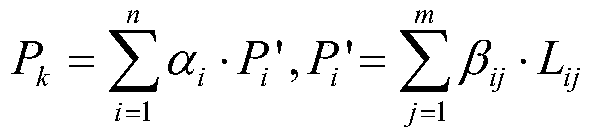
[0045] Step S2, describe and analyze the risk source, reflect the degree of harm of the risk source to the receptor by its probability and intensity, and obtain the risk degree (P) of the risk source;

[0046] Step S3, select risk receptors and determi...