Detection system and detection method of soil temperature-humidity three-dimension map based on unmanned aerial vehicle and acoustic surface wave sensor nodes

A technology of sensor nodes and surface acoustic wave devices, which is applied in the direction of physical/chemical change thermometers, thermometers, and analysis of solids using sound waves/ultrasonic waves/infrasonic waves to achieve low prices, fast response speeds, and small measurement errors.

Active Publication Date: 2019-09-06
NANJING UNIV OF AERONAUTICS & ASTRONAUTICS +2
View PDF4 Cites 2 Cited by
  • Summary
  • Abstract
  • Description
  • Claims
  • Application Information

AI Technical Summary

Problems solved by technology

[0009] The present invention aims at the actual situation that it is difficult to obtain mesoscale field soil temperature and humidity measurement data based on aerial photography plots and the problems existing in existing soil temperature and humidity detection methods, and proposes a soil based on UAV and surface acoustic wave sensor nodes. The temperature and humidity three-dimensional map detection system and detection method, the purpose of which is to obtain the three-dimensional temperature and humidity map of mesoscale soil and its change over time through unmanned aerial vehicles, to provide theoretical basis and practical decision-making for precision irrigation

Method used


Image

  • Detection system and detection method of soil temperature-humidity three-dimension map based on unmanned aerial vehicle and acoustic surface wave sensor nodes
  • Detection system and detection method of soil temperature-humidity three-dimension map based on unmanned aerial vehicle and acoustic surface wave sensor nodes
  • Detection system and detection method of soil temperature-humidity three-dimension map based on unmanned aerial vehicle and acoustic surface wave sensor nodes

Examples


Embodiment Construction

[0043] The present invention will be further described below in conjunction with the accompanying drawings.

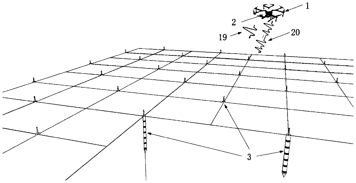
[0044] Please refer to figure 1 As shown, the soil temperature and humidity three-dimensional map detection system based on UAV and surface acoustic wave sensor nodes in the present invention is composed of UAV 1, reader 2 and several surface acoustic wave sensor nodes 3; wherein, reader 2 is carried on On the drone 1, several surface acoustic wave sensor nodes 3 are distributed in the field soil to be detected.

[0045] The reader 2 includes a reader transceiver circuit and a reader antenna; the reader antenna is a miniaturized microstrip antenna fixed on the bottom of the UAV 1 .

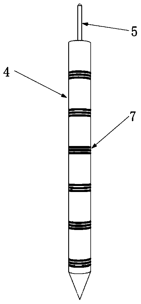
[0046] According to the spatial heterogeneity characteristics of field soil temperature and humidity and the scale requirements of temperature and humidity detection data, several surface acoustic wave sensor nodes 3 are arranged in the field soil to be detected according to certain topol...


PUM


Abstract

The invention discloses a detection system and a detection method of a soil temperature-humidity three-dimension map based on an unmanned aerial vehicle and acoustic surface wave sensor nodes. The detection system is mainly characterized in that the advantage of rapid routing inspection of the unmanned aerial vehicle on farmland is exerted, a reader is carried on the unmanned aerial vehicle, a plurality of acoustic surface wave sensor nodes are distributed in farmland soil to be detected according to a certain topological rule, the unmanned aerial vehicle is used for obtaining the temperature-humidity three-dimension map of medium-sized soil and a change rule along the time, and theoretical basis and practical decision are provided for precise irrigation. According to the detection systemand the detection method of the soil temperature-humidity three-dimension map based on the unmanned aerial vehicle and acoustic surface wave sensor nodes, each acoustic surface wave sensor node is formed by connecting a plurality of single-end delay line type acoustic surface wave devices in parallel; each device comprises four reflecting gratings; and the structure is capable of completing the function of sensing temperature and humidity of the soil in parallel and is also capable of simultaneously detecting temperature and humidity values of different depth layer grades in the same surface position.

Description

[0001] Technical field: [0002] The invention relates to a soil temperature and humidity three-dimensional map detection system and detection method based on unmanned aerial vehicles and surface acoustic wave sensor nodes, belonging to the fields of soil detection and wireless sensing. [0003] Background technique: [0004] In modern agricultural operations, in order to achieve precise irrigation, it is necessary to monitor soil moisture (water content) and temperature through sensors, and use the actually obtained soil temperature and humidity information as the basis for decision-making to implement targeted irrigation. Due to the combined effects of topography, microclimate, vegetation type, soil physical and chemical properties, and human activities, even in the same area, soil temperature and humidity show a high degree of heterogeneity in time and three-dimensional space (including the direction of soil depth). sex. Therefore, it is necessary to study the spatiotempora...

Claims


Application Information

Patent Timeline
Patent Type & Authority Applications(China)
IPC IPC(8): G01N29/04G01N29/24G01N29/44
CPCG01N29/04G01N29/2437G01N29/44G01K11/265G01N2291/02441G01N2291/02845G01N2291/0423G01N2291/106G01N2291/02881
Inventor 陈智军贾浩张国维刘志鹏黄鸿伟代重阳熊志强徐辅庆
Owner NANJING UNIV OF AERONAUTICS & ASTRONAUTICS
Why Eureka
Try Eureka