Geographic grid division method, business district determination method and equipment

A technology for geographic grids and business districts, applied in business, data processing applications, instruments, etc., can solve problems such as low mining accuracy, inability to support multi-level business district mining, and inability to meet business scenarios, and achieve accurate score calculation results Effect

Pending Publication Date: 2019-10-18
TENCENT TECH (SHENZHEN) CO LTD
View PDF0 Cites 6 Cited by
  • Summary
  • Abstract
  • Description
  • Claims
  • Application Information

AI Technical Summary

Problems solved by technology

Existing automatic algorithm mining solutions have problems such as low mining accuracy, inability t...

Method used


Image

  • Geographic grid division method, business district determination method and equipment
  • Geographic grid division method, business district determination method and equipment
  • Geographic grid division method, business district determination method and equipment

Examples


Embodiment Construction

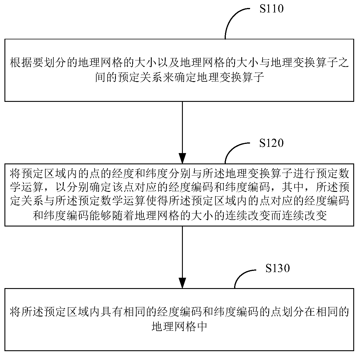
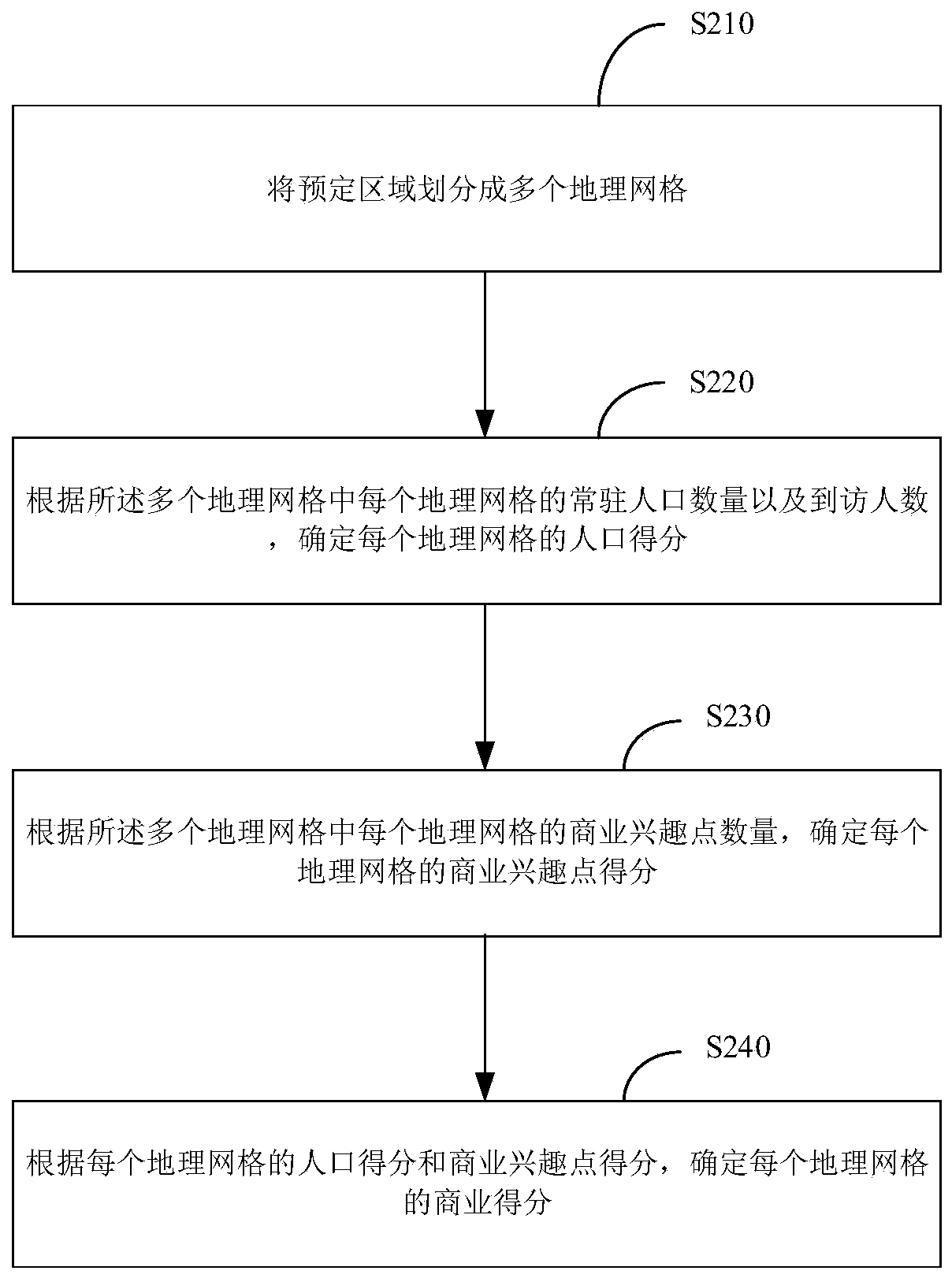
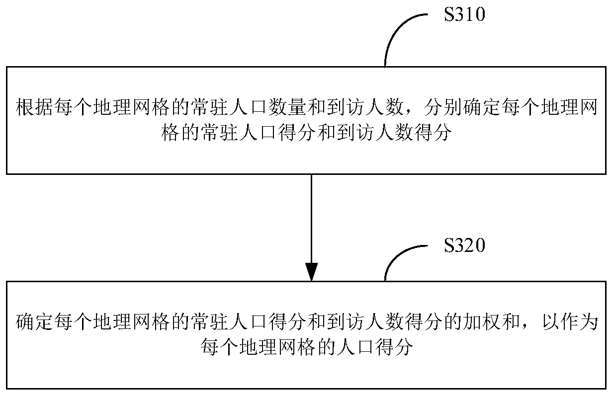
[0121] Example embodiments will now be described more fully with reference to the accompanying drawings. However, example embodiments may be embodied in many forms and should not be construed as limited to the examples set forth herein; rather, these example embodiments are provided so that the description of the embodiments of this application will be thorough and complete, and will The concepts of are fully conveyed to those skilled in the art. The drawings are merely schematic illustrations of embodiments of the present application and are not necessarily drawn to scale. The same reference numerals in the drawings denote the same or similar parts, and thus repeated descriptions thereof will be omitted.

[0122] Furthermore, the described features, structures, or characteristics may be combined in any suitable manner in one or more example embodiments. In the following description, numerous specific details are provided in order to give a thorough understanding of example ...


PUM


Abstract

The invention provides a geographic grid division method, a business district determination method and equipment. The geographic grid division method comprises the following steps: determining a geographic transformation operator according to the size of the geographic grids to be divided and a predetermined relationship between the size of the geographic grids and the geographic transformation operator; respectively carrying out predetermined mathematical operation on the longitude and latitude of the point in the predetermined area and the geographical transformation operator, wherein the predetermined relationship and the predetermined mathematical operation enable the longitude codes and the latitude codes corresponding to the points in the predetermined region to be continuously changed along with the continuous change of the size of the geographic grid; and dividing the points with the same longitude codes and latitude codes in the predetermined area into the same geographic grid. According to the embodiment of the invention, the geographic grid division method can achieve the continuous adjustment of the geographical range precision of the business district.

Description

technical field [0001] The embodiment of the present application relates to the field of computer and communication technology, and specifically relates to a method for dividing a geographical grid, a method for determining a business district, a device, and a computer-readable storage medium. Background technique [0002] The geographical scope of business circles has very important commercial value and is the basic geographic data required for offline business operations. The determination of the geographic scope of business districts is mainly divided into two types: manual mapping and automatic algorithm mining. Manual drawing requires manual drawing of the geographical range of business districts on the map based on one’s own understanding, which needs to be drawn one by one, which is inefficient and consumes a lot of manpower and material resources. Algorithm-based mining is based on the collected geographic data, and an algorithm program is designed to automatically ...

Claims


Application Information

Patent Timeline
IPC IPC(8): G06Q30/02
CPCG06Q30/0205
Inventor 张长旺张纪红黄新营
Owner TENCENT TECH (SHENZHEN) CO LTD
Why Eureka
Try Eureka