Forest fire spreading data assimilation method and device based on unmanned aerial vehicle video

A forest fire spread and data technology, applied in the field of forest fire spread data assimilation, can solve the problems of high spatial resolution, insufficient flexibility, and inability to achieve full-time and full-region coverage of remote sensing images

Pending Publication Date: 2021-03-09
TSINGHUA UNIV +1
View PDF0 Cites 7 Cited by
  • Summary
  • Abstract
  • Description
  • Claims
  • Application Information

AI Technical Summary

Problems solved by technology

Geostationary satellites have a high orbital altitude, wide coverage, and high frequency of observation, but the spatial resolution is relatively low. Geostationary satellites generally detect fires with a size of kilometers, and it is difficult to effectively monitor small fires.
Compared with geostationary satellites, the spatial resolution of remote sensing images collected by polar orbiting satellites is higher, and the observation frequency is lower. Even if multiple series of various types of polar orbiting satellites are used to observe the earth at the same time, it can only achieve an observation frequency of about 10 times a day at any location. , unable to achieve full-time, full-area coverage
When the fire area is blocked by terrain, the satellite remote sensing sensor cannot monitor the blocked area, and the satellite remote sensing has poor mobility and insufficient flexibility
Remote sensing technology cannot fully meet the requirements of real-time fire monitoring in terms of resolution, timeliness and flexibility

Method used


Image

  • Forest fire spreading data assimilation method and device based on unmanned aerial vehicle video
  • Forest fire spreading data assimilation method and device based on unmanned aerial vehicle video
  • Forest fire spreading data assimilation method and device based on unmanned aerial vehicle video

Examples


Embodiment Construction

[0040] Embodiments of the present application are described in detail below, examples of which are shown in the drawings, wherein the same or similar reference numerals denote the same or similar elements or elements having the same or similar functions throughout. The embodiments described below by referring to the figures are exemplary, and are intended to explain the present application, and should not be construed as limiting the present application.

[0041] The method, device, electronic equipment, and storage medium for data assimilation of forest fire spread based on drone video according to the embodiments of the present application are described below with reference to the accompanying drawings.

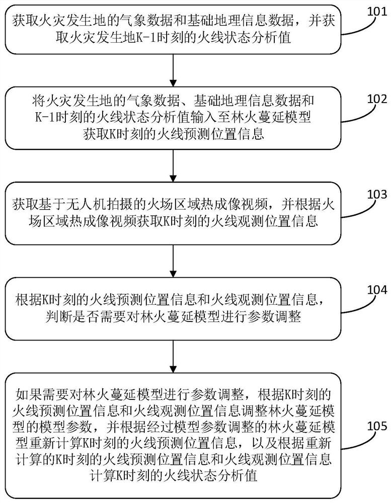
[0042] figure 1 It is a flow chart of a method for assimilating forest fire spread data based on drone video according to an embodiment of the present application. It should be noted that the forest fire spread data assimilation method of the embodiment of the present appl...


PUM


Abstract

The invention discloses a forest fire spreading data assimilation method and device based on an unmanned aerial vehicle video, electronic equipment and a computer readable storage medium. The method comprises the following steps: acquiring meteorological data and basic geographic information data of a fire place and a live wire state analysis value at the moment K1; inputting the above informationinto a forest fire spreading model, and obtaining live wire prediction position information at the moment K; acquiring a fire scene area thermal imaging video shot based on the unmanned aerial vehicle, and acquiring live wire observation position information at the moment K; judging whether parameter adjustment needs to be carried out on the model or not according to the live wire prediction position and the observation position at the moment K; and if adjustment is needed, adjusting model parameters according to the live wire prediction position and the observation position at the K moment,and recalculating the live wire prediction position at the K moment to obtain a live wire state analysis value at the K moment. The method is low in cost, the forest fire spreading model can be dynamically iterated, the accurate live wire prediction position is obtained, and precious time is bought for forest fire rescue.

Description

technical field [0001] The application relates to the field of data processing, in particular to a method, device, electronic equipment and storage medium for data assimilation of forest fire spread based on drone video, belonging to the field of data assimilation applications. Background technique [0002] Forest fire disasters cannot be controlled, and forest fires will destroy forest ecosystems, cause environmental pollution, and threaten the safety of human life and property. When a fire occurs, emergency management workers urgently need to obtain front-line fire information and accurate forest fire spread prediction information in a short period of time, so as to gain valuable time for emergency rescue and fire fighting. [0003] However, the existing fire line position acquisition is mostly based on satellite remote sensing data. Due to the limitation of satellite orbit, the time resolution and spatial resolution of satellite remote sensing forest fire monitoring are m...

Claims


Application Information

Patent Timeline
Patent Type & Authority Applications(China)
IPC IPC(8): G06K9/00G08B17/12G06F16/29
CPCG08B17/125G06F16/29G06V20/188G06V20/40Y02A40/28
Inventor 陈涛黄丽达孙占辉袁宏永刘春慧王晓萌白硕张立凡王镜闲
Owner TSINGHUA UNIV
Why Eureka
Try Eureka