Land software tool

a software tool and land technology, applied in the field of land software tools, can solve the problems of not having extensive functionality for locating the entire set of tools that work together in a synergistic fashion

Inactive Publication Date: 2006-06-15
LANDNET CORP
View PDF54 Cites 67 Cited by
  • Summary
  • Abstract
  • Description
  • Claims
  • Application Information

AI Technical Summary

Benefits of technology

[0010] An embodiment of the present invention may further comprise a method of locating a boundary on a plurality of digital maps and images comprising: obtaining a first digital map with the boundary overlaid on the first digital map, wherein the boundary is comprised of a plurality of boundary points delineating screen coordinates of the boundary on the first digital map; analyzing the screen coordinates of the plurality of boundary points; generating geographic coordinates for the plurality of boundary points in response to analysis of the screen coordinates; generating lines between the geographic coordinates of the plurality of boundary points to produce boundary lines of the boundary; displaying the boundary lines; displaying the plurality of boundary points and the boundary lines at corresponding geographic locations on additional digital maps and images; toggling between the additional digital maps and images to view the location of the plurality of boundary points and the boundary lines on the additional digital maps and images; and adjusting the location of the plurality of boundary points, as needed, to accurately locate the plurality of boundary points on the first digital map and the additional digital maps and images.
[0011] An embodiment of the present invention may further comprise a method of locating a boundary point on a plurality of digital maps and images comprising: obtaining a first digital map with said boundary point overlaid on said first digital map, wherein said boundary point has screen coordinates on said first digital map; analyzing said screen coordinates of said boundary point; generating geographic coordinates for said boundary point in response to analysis of said screen coordinates; displaying said boundary point at a corresponding geographic location on additional digital maps and images; toggling between said additional digital maps and images to view the location of said boundary point on said additional digital maps and images; and adjusting said location of said boundary point, as needed, to accurately locate said boundary point on said first digital map and said additional digital maps and images.

Problems solved by technology

However, a comprehensive set of tools that work together in a synergistic fashion have not been provided with extensive functionality for locating, identifying, measuring, viewing and communicating such data in a simple and easy to use tool that operates over the Internet, intranets, wireless connections or any desired network (otherwise referred to as a “network”) using standard browsers and e-mail tools.

Method used


Image

  • Land software tool
  • Land software tool
  • Land software tool

Examples


Embodiment Construction

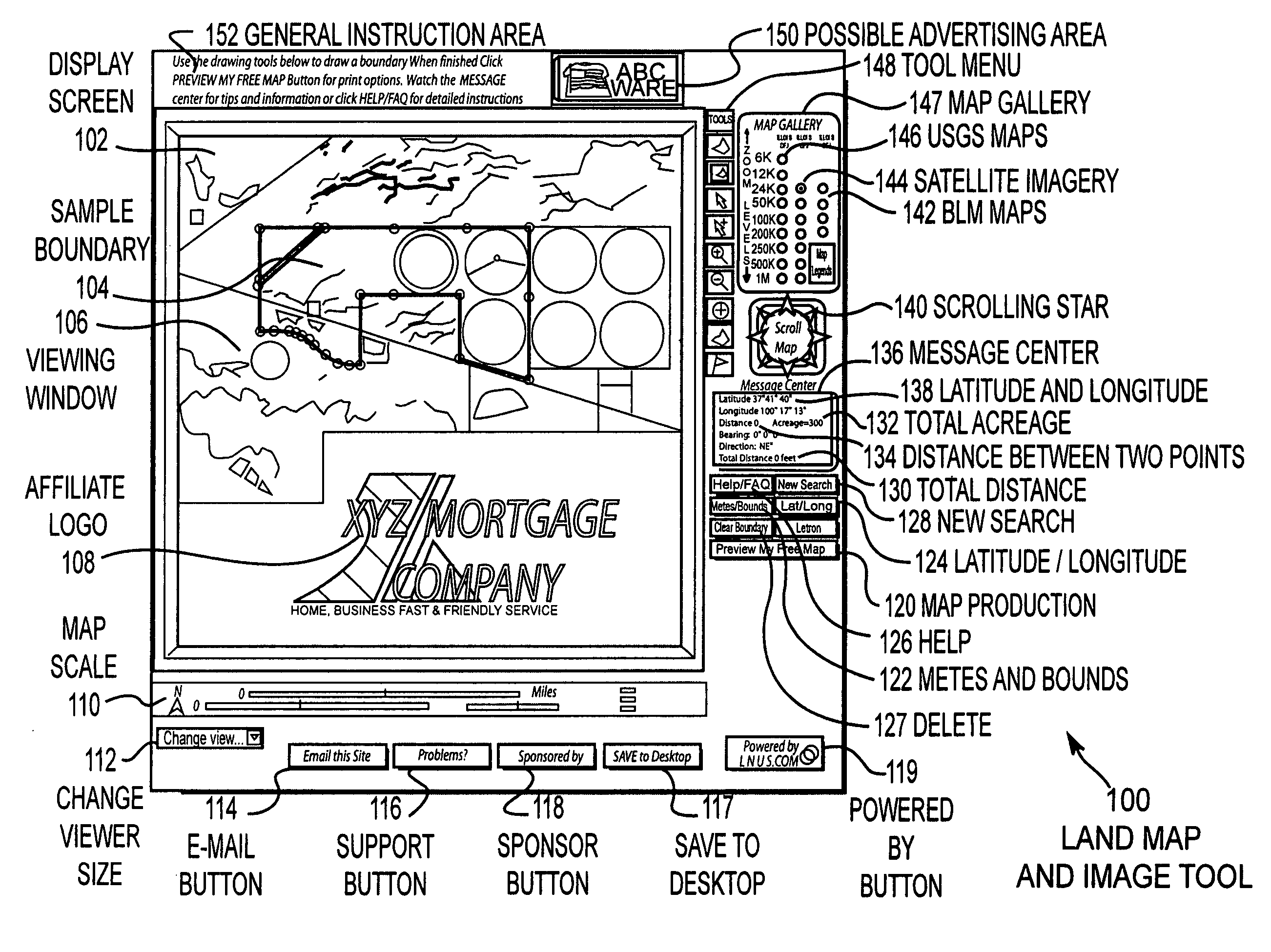
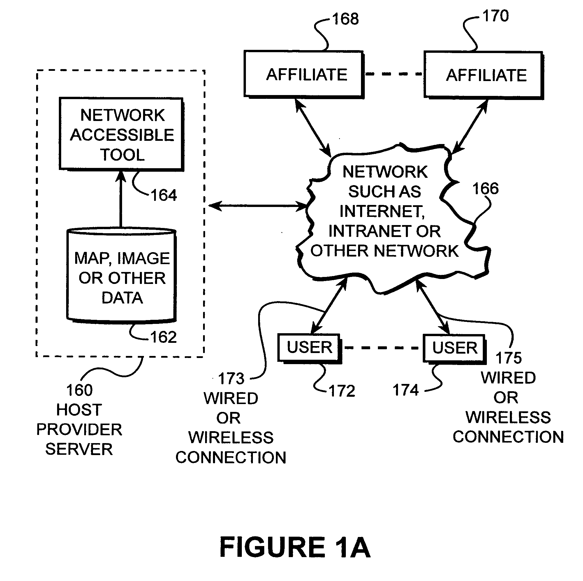
[0033]FIG. 1a discloses the manner in which the network accessible tool 164 is employed in accordance with the present invention. As shown in FIG. 1a, a host provider server 160 is established that includes the network accessible tool 164 and map, image and other data 162. The host provider server 160 is connected to a network 166 such as the Internet, WAN, LAN or other network via wired or wireless connections 173, 175 to allow any number of users 172, 174 that are connected to the network 166 to have access to the host provider server 160. In addition, a number of affiliates 168, 170 may also be connected to the network 166. Users 172, 174 may select a link when logged onto an affiliate website, which links the user into the host provider server 160. This link may be provided by a button on the affiliate's website, as disclosed above, such as “Print a Free Map of Your Land” or other promotional item. For example, for affiliates involved in land finance, appraisal and transactions,...


PUM


Abstract

Disclosed is a network accessible tool that is capable of providing map and satellite image data, as well as other photographic image data to locate, identify, measure, view, and communicate information about land over the Internet-to-Internet users. The network accessible tool includes a location tool that allows the user to locate areas on a map using geographic names, township, range and section descriptions, county names, latitude and longitude coordinates or zip codes. Network accessible tool also includes a metes and bounds tool that draws boundaries on the map and image data in response to metes and bounds descriptions that have been entered by the Internet user. The network accessible tool also includes a lat / long drawing tool that draws boundaries on the map and image data based upon latitude and longitude coordinate pairs that have been entered by the Internet user. A cursor drawing tool allows the Internet user to draw and edit boundaries on the map and image data by simply clicking the cursor on the corner points of the boundary. An acreage calculation tool is also provided that calculates the acreage of an enclosed boundary. A distance measurement tool is also provided. The cursor information tool provides information relating to the name and creation date of the map and image data in accordance with the location of the cursor on the screen. The information can be communicated by printing, downloading, or e-mailing.

Description

CROSS REFERENCE TO RELATED APPLICATIONS [0001] This application is a continuation of U.S. patent application Ser. No. 10 / 365,718, entitled “Land Software Tool,” filed on Feb. 11, 2003 by Craig D. Harrison and James J. Graham, which was based upon and claims the benefit of U.S. Provisional Patent Application Ser. No. 60 / 356,405 by Craig D. Harrison entitled “An Internet Delivered and Accessible Set of Maps, Images, and Tools for Locating, Identifying, Measuring, Viewing, and Communicating Information about Land and Areas of Land” filed Feb. 11, 2002, the entire contents of which is hereby specifically incorporated by reference for all it discloses and teaches.BACKGROUND OF THE INVENTION [0002] Map and image data, including satellite data and aerial photographic data, which is hereinafter referred to as maps, map information, map data and includes any type of image data, have been provided through various databases and mass storage devices such as CD / ROMs. However, a comprehensive set...

Claims


Application Information

Patent Timeline
Patent Type & Authority Applications(United States)
IPC IPC(8): G06T11/20G06Q10/10G06Q40/00
CPCG06F17/30241G06F17/30997G06Q10/10G06Q40/00G06Q40/08G06F16/907G06F16/29
Inventor HARRISON, CRAIG D.GRAHAM, JAMES J.
Owner LANDNET CORP
Why Eureka
Try Eureka