Global Satellite Positioning System Gunfire Detection System

Inactive Publication Date: 2010-05-13
CHU CHARLES
View PDF6 Cites 14 Cited by
  • Summary
  • Abstract
  • Description
  • Claims
  • Application Information

AI Technical Summary

Benefits of technology

[0008]One objective of the present invention is to provide a GPS gunfire detection system able to transmit circumstances regarding an object being hit by bullets and gunshot information to a remote server to enable location of the gunfire to be calculated, and notify relevant authorities, and thereby speed up emergency aid to personnel and rescue of casualties.
[0009]According to the aforementioned objective, the GPS gunfire detection system of the present invention comprises a plurality of detectors disposed on an object (such as: a bus, an army vehicle, a police vehicle, bulletproof clothing, and so on), and each of the detectors is provided with several microphones. A GPS tracker is located close to a position on the object, and the GPS tracker is provided with a GPS receiving circuit, a microprocessor and a signal receiving / transmission circuit. Accordingly, the detectors can detect circumstances regarding the object being hit by bullets and collect gunshot sounds, and the detected information and gunshot sounds are transmitted to the microprocessor of the GPS tracker. The GPS receiving circuit of the GPS tracker receives geographic positioning satellite coordinate signals, after which the geographic positioning satellite coordinate signals are matched with an internal prestored geographic data base to obtain the position of the object, whereupon the position is transmitted to the microprocessor. When in use, the microprocessor transmits information on the position of the object, circumstances regarding being hit by bullets and gunshot information to a remote server using the signal transmission circuit to enable recording the gunshot sounds in order to calculate the location of the gunfire and notify relevant authorities, thereby enabling speeding up emergency aid to personnel and rescue of casualties.

Problems solved by technology

However, satellite navigators of the prior art are only able to indicate current position, route direction and neighboring buildings, and are not used to record circumstances of an object (such as: a bus, an army vehicle, a police vehicle, bulletproof clothing, and so on) being hit by bullets and calculate location of the gunfire, resulting in the inability to effectively speed up the rescue of personnel, and thus limiting use range thereof.

Method used


Image

  • Global Satellite Positioning System Gunfire Detection System
  • Global Satellite Positioning System Gunfire Detection System
  • Global Satellite Positioning System Gunfire Detection System

Examples


Embodiment Construction

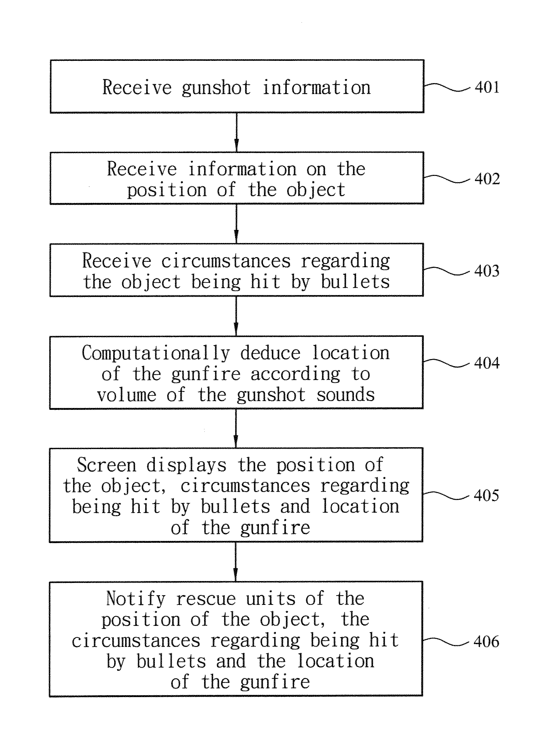
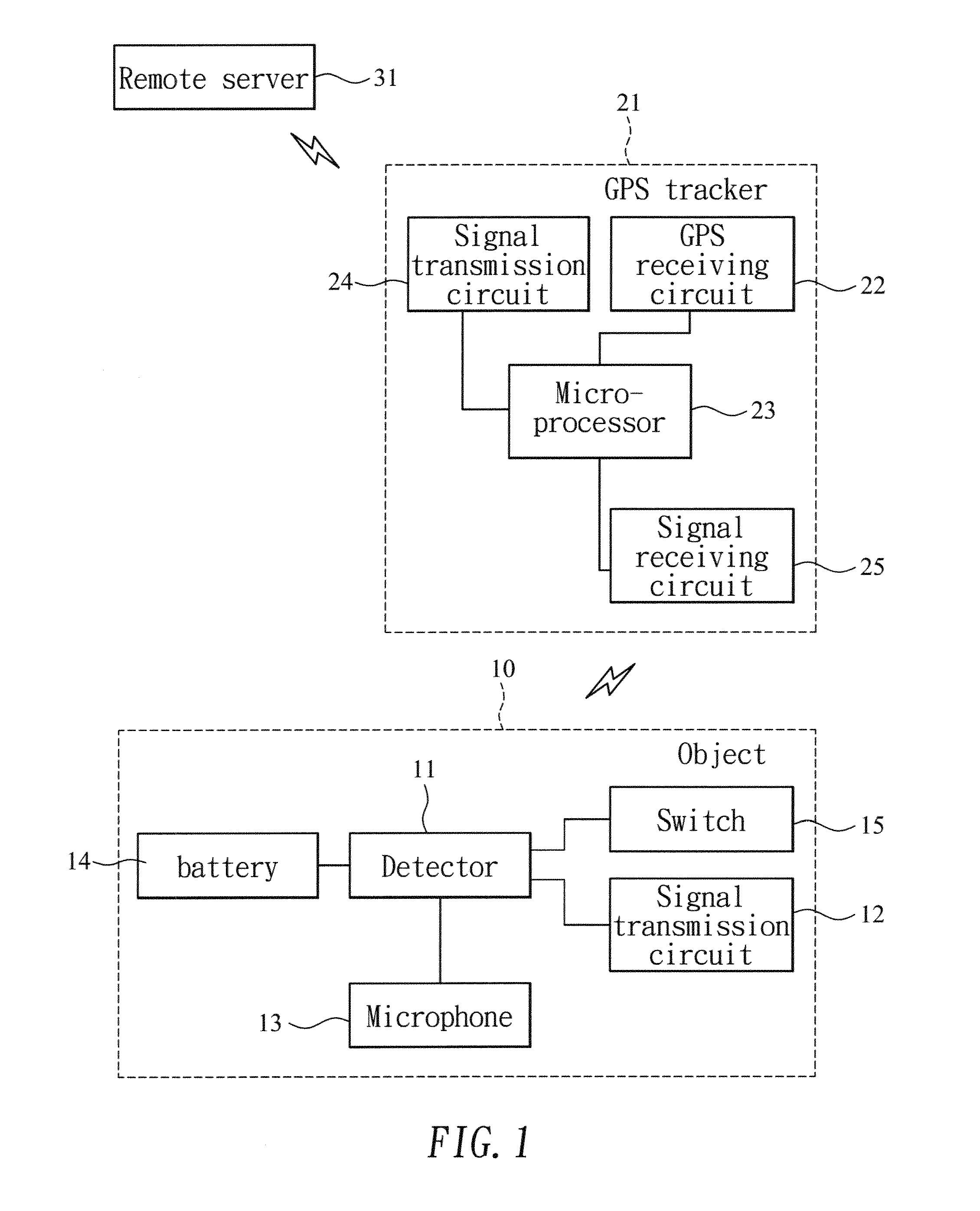
[0015]The present invention relates to a GPS gunfire detection system. Referring to FIGS. 1 and 2, which show a GPS (Global Satellite Positioning System) gunfire detection system of the present invention, wherein a plurality of detectors 11 and signal transmission circuits 12 are disposed on selected areas of an object 10 (such as: a bus, an army vehicle, a police vehicle, bulletproof clothing, and so on), and each of the detectors 11 is provided with a number of microphones 13 to enable the collection of gunfire sounds. A GPS tracker 21 is located close to a position on the object 10, and the GPS tracker 21 is provided with a GPS receiving circuit 22, a microprocessor 23, a signal transmission circuit 24 and a signal receiving circuit 25. The detectors 11 on the object 10 are connected to the signal transmission circuits 12, the detectors 11 enable detecting circumstances regarding the object 10 being hit by bullets, and the microphones 13 are used to collect gunshot sounds. Moreov...


PUM


Abstract

A GPS gunfire detection system, which includes a plurality of detectors, each of which is provided with several microphones, disposed on an object, and a GPS tracker is located close to the object. The detectors detect circumstances regarding the object being hit by bullets and collect gunshot sounds, the detected information and gunshot sounds being transmitted to the GPS tracker. A GPS receiving circuit of the GPS tracker receives geographic positioning satellite coordinate signals, which are matched with an internal prestored geographic data base to obtain the object position, which is then transmitted to a microprocessor of the GPS tracker, from where information on the object position, circumstances surrounding the gunfire and gunshot sounds are transmitted to a remote server using a signal transmission circuit to enable calculating the location of the gunfire and notifying relevant authorities, thereby enabling speeding up emergency aid to personnel and rescue of casualties.

Description

BACKGROUND OF THE INVENTION[0001](a) Field of the Invention[0002]The present invention relates to a GPS (Global Satellite Positioning System) gunfire detection system, and more particularly to a GPS tracker device able to transmit circumstances regarding an object being hit by bullets and gunshot information to a remote server to enable location of the gunfire to be calculated, and notify rescue units.[0003](b) Description of the Prior Art[0004]Since development of the global satellite positioning system (GPS) by the American Military, and after the government made the GPS open to public use, there has been continuous advancement in related technology and technical products, including application in various industries and at various levels, greatly increasing the standard of living of people and improving convenience in daily life, even accelerating notification of emergencies and the speed of medical rescue.[0005]The global satellite positioning system consists of several space sat...

Claims


Application Information

Patent Timeline
IPC IPC(8): G01S1/00
CPCG01S5/18G01S5/0036
Inventor CHU, CHARLES
Owner CHU CHARLES
Why Eureka
Try Eureka