Method and system for geo-demographic classification of a geographical region

a geodemographic and geographical region technology, applied in the field of geographical region classification, can solve the problems of large investment in manpower and money, long turn-around time of clustering solutions, and limited scope of prior art literature, so as to achieve the effect of being convenient to use, convenient to use, and fast and easy to us

Inactive Publication Date: 2016-10-13
TATA CONSULTANCY SERVICES LTD
View PDF0 Cites 7 Cited by
  • Summary
  • Abstract
  • Description
  • Claims
  • Application Information

AI Technical Summary

Benefits of technology

[0014]The present application provides an inexpensive and faster and method and system for geo-demographic classification of a geographical region.
[0015]The present application provides a computer implemented unsupervised method for geo-demographic classification of at least one geographical region. The method includes pre-processing of a satellite image of said geographical region; dividing pre-processed satellite image of said geographical region into a plurality of blocks; and dividing each block into a plurality of patches for visual characterization of said geographical region; extracting visual features of said plurality of patches; clustering and labeling said plurality of patches using a combination of said extracted visual features; clustering said plurality of blocks based on the distribution of said labeled plurality of patches; removing post clustering noise of satellite image of said geographical region; pre-processing of multimodal sensory data originated from said geographical region; clustering and labeling of pre-processed multimodal sensory data; aligning pre-processed multimodal sensory data with the clustered and labeled satellite image of said geographical region; extracting corresponding labels of aligned multimodal sensory data and the clustered and labeled satellite image of said geographical region; clustering integrated multimodal sensory data with the clustered and labeled satellite image of said geographical region for obtaining geo-demographic classification of said geographical region; and neighborhood labeling the obtained geo-demographic clusters of said geographical region.

Problems solved by technology

Such manual demographic clustering solution(s) exhibit practical constraints of long turn-around time, investment of significant manpower and money.
However, the scope of said prior art is confined to distinguishing between slums or no slums.
However, the prior art literature has never explored application of satellite imagery in conjugation with multimodal sensory data in geo-demographic analysis or clustering.
However, use of unsupervised learning methods for analyzing big multimedia and multimodal data including satellite imagery and multimodal sensory data in fusion for geo-demographic clustering is still considered as one of the biggest challenges of the technical domain.

Method used


Image

  • Method and system for geo-demographic classification of a geographical region
  • Method and system for geo-demographic classification of a geographical region
  • Method and system for geo-demographic classification of a geographical region

Examples


Embodiment Construction

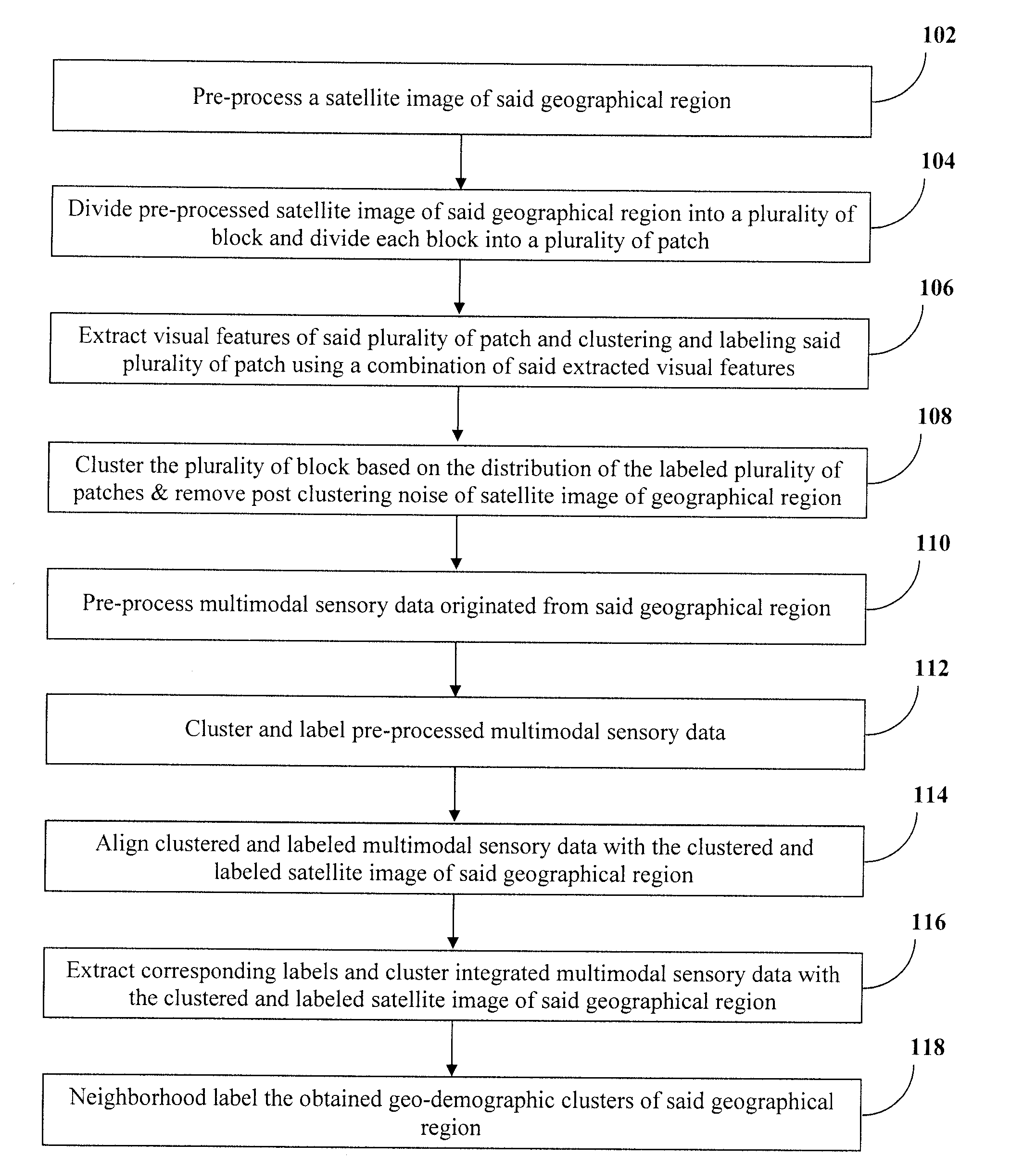
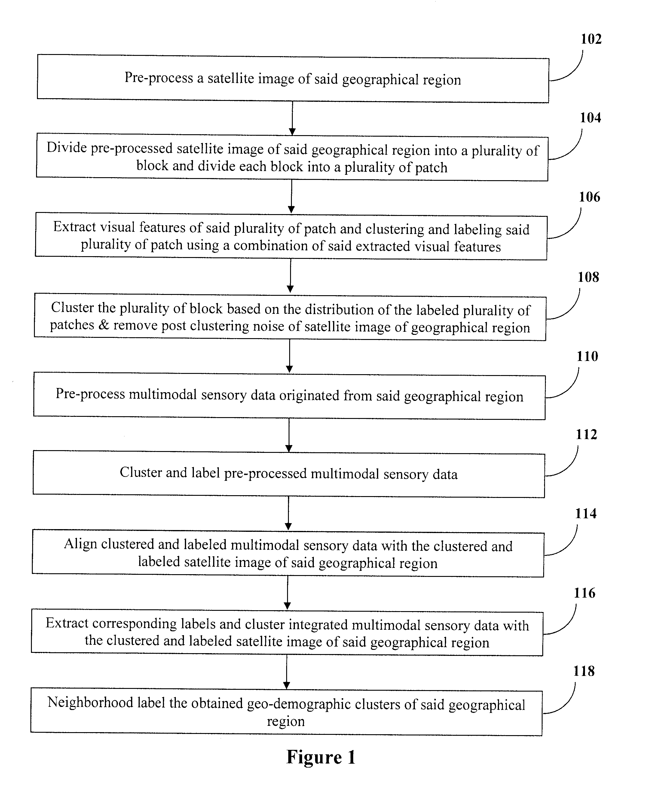
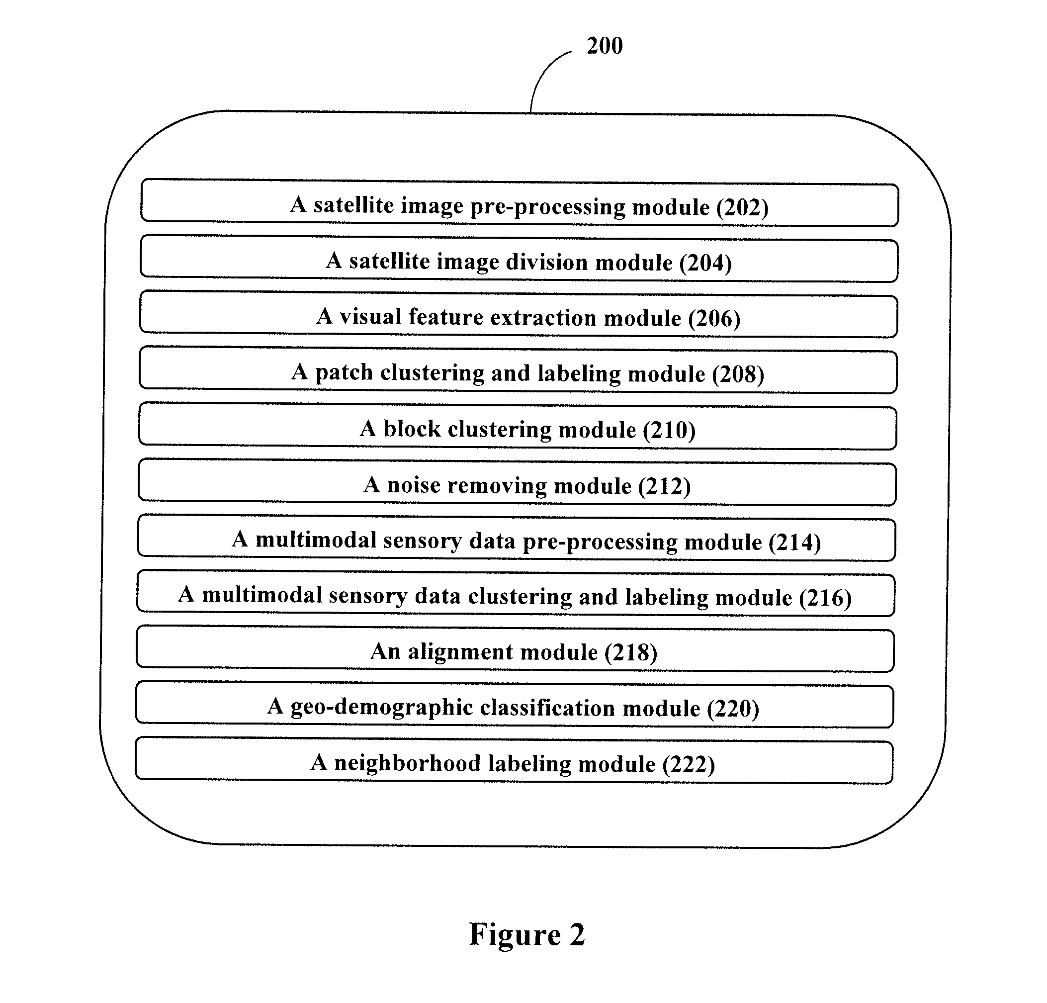
[0020]The present invention will now be described more fully hereinafter with reference to the accompanying drawings and diagrams in which exemplary embodiments of the invention are shown. However, the invention may be embodied in many different forms and should not be construed as limited to the representative embodiments set forth herein. The exemplary embodiments are provided so that this disclosure will be both thorough and complete, and will fully convey the scope of the invention and enable one of ordinary skill in the art to make, use and practice the invention. Like reference numbers refer to like elements throughout the various drawings.

[0021]The words “comprising,”“having,”“containing,” and “including,” and other forms thereof, are intended to be equivalent in meaning and be open ended in that an item or items following any one of these words is not meant to be an exhaustive listing of such item or items, or meant to be limited to only the listed item or items.

[0022]It mus...


PUM


Abstract

A method and system is provided for geo-demographic classification of a geographical region. The present application discloses an unsupervised learning method and system for analyzing satellite imagery and multimodal sensory data in fusion for geo-demographic clustering. The present application also discloses an inexpensive and faster method and system for geo-demographic classification of a geographical region.

Description

CROSS-REFERENCE TO RELATED APPLICATIONS AND PRIORITY[0001]The present application claims priority from Indian Patent Application No. 1515 / MUM / 2015, filed on Apr. 10, 2015, the entirety of which is hereby incorporated by reference.TECHNICAL FIELD[0002]The present application generally relates to the classification of a geographical region. Particularly, the application provides a method and system for geo-demographic classification of a geographical region. More particularly, the application provides a method and system for geo-demographic classification of a geographical region using big multimedia and multimodal data consisting of satellite imagery and other sensory data.BACKGROUND[0003]A typical populated geographical region such as a city may be divided into numerous quarters. Different quarters of the geographical region may have people of different socio-economic backgrounds living therein, and the basic assumption is that neighborhoods in any given geographical region generall...

Claims


Application Information

Patent Timeline
Patent Type & Authority Applications(United States)
IPC IPC(8): G06K9/00G06K9/46G06T7/60G06T7/40G06K9/52G06K9/62G06T7/00G06V20/13
CPCG06K9/00476G06K9/6267G06K9/4652G06K9/6218G06T7/0028G06T2207/30181G06K9/52G06T7/60G06K2009/4666G06T2207/20032G06T7/408G06T11/00G06T7/33G06T7/90G06V20/13G06V10/811G06F18/256G06V30/422G06F18/23G06F18/24
Inventor SHARMA, MONIKAGHOSH, HIRANMAYFRANCIS, KIRAN
Owner TATA CONSULTANCY SERVICES LTD
Why Eureka
Try Eureka