Ellipse expanding and imaging method and device for seismic data processing under true earth surface condition

An ellipse expansion, seismic data technology, applied in seismic signal processing and other directions, can solve complex problems, achieve objective and real processing results, and satisfy complex surface and complex structure imaging effects

Active Publication Date: 2010-12-01
恒泰艾普集团股份有限公司
View PDF5 Cites 14 Cited by
  • Summary
  • Abstract
  • Description
  • Claims
  • Application Information

AI Technical Summary

Problems solved by technology

[0006] In order to solve the problem of complex surface and complex structure imaging, the embodiment of the present ...

Method used


Image

  • Ellipse expanding and imaging method and device for seismic data processing under true earth surface condition
  • Ellipse expanding and imaging method and device for seismic data processing under true earth surface condition
  • Ellipse expanding and imaging method and device for seismic data processing under true earth surface condition

Examples


Embodiment 1

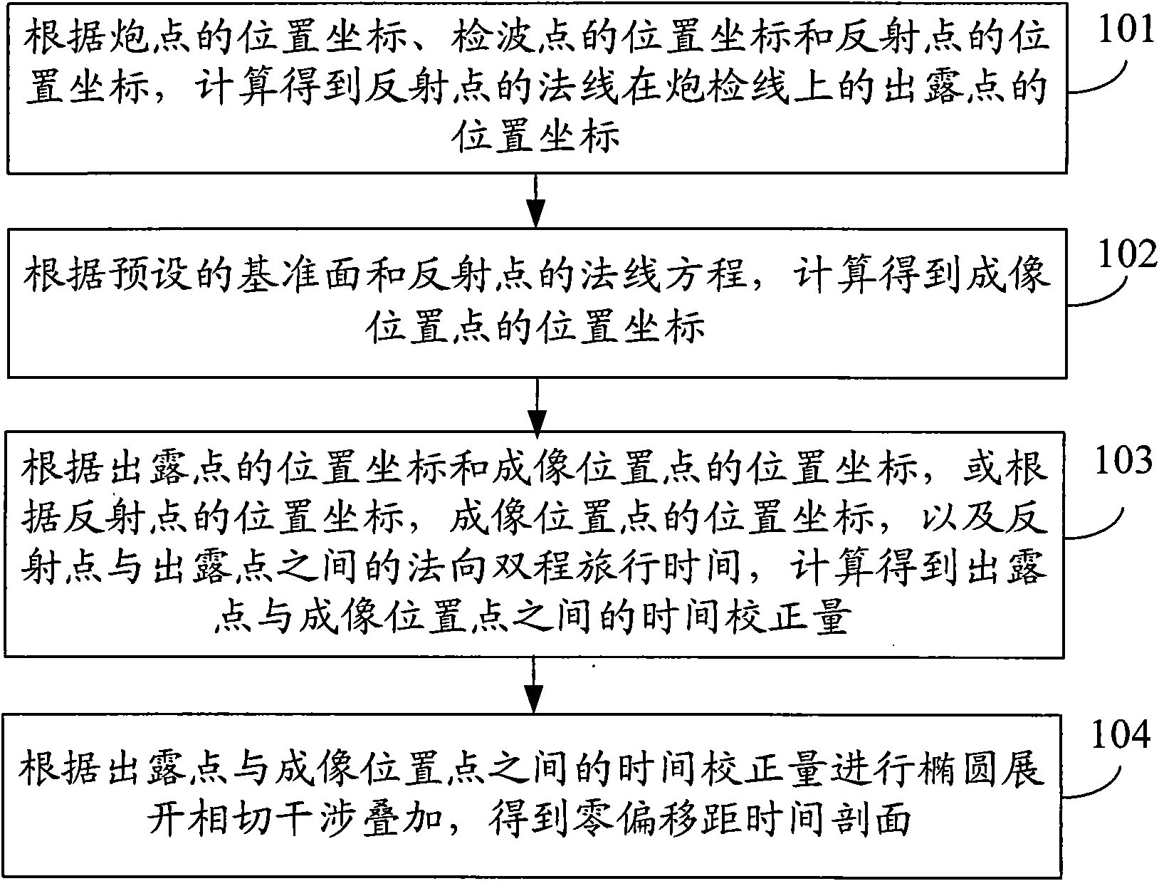
[0034] see figure 1 , the embodiment of the present invention provides an ellipse expansion imaging method under the real surface condition of seismic data processing, the method considers the surface undulation, but does not consider the non-uniformity of the near-surface velocity, the method includes:

[0035] 101: According to the position coordinates of the shot point, the position coordinates of the receiver point and the position coordinates of the reflection point, calculate and obtain the position coordinates of the dew point where the normal of the reflection point is on the shot detection line.

[0036] 102: Calculate and obtain the position coordinates of the imaging position point according to the preset datum plane and the normal equation of the reflection point.

[0037] 103: According to the position coordinates of the dew point and the position coordinates of the imaging position point, or according to the position coordinates of the reflection point, the posit...

Embodiment 2

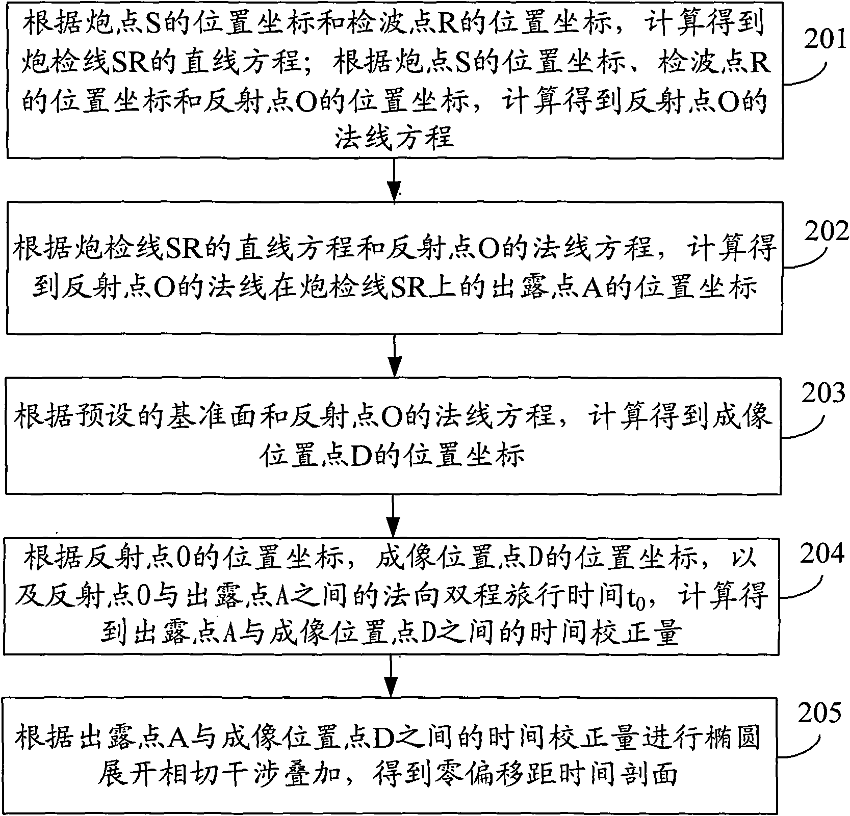
[0049] see figure 2 and image 3 , the embodiment of the present invention provides an ellipse expansion imaging method under the real surface condition of seismic data processing, the method considers the surface undulation, but does not consider the non-uniformity of the near-surface velocity, the method includes:

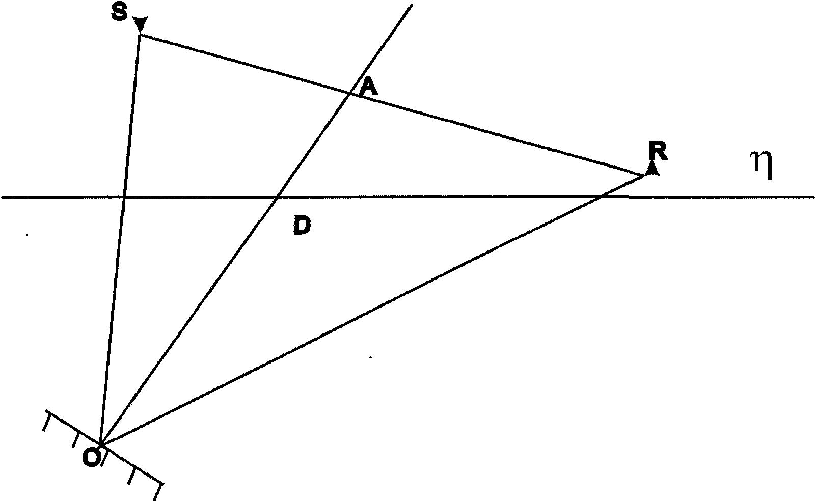
[0050] 201: Assuming that the position coordinates of the shot point S, the position coordinates of the receiver point R and the position coordinates of the reflection point O are known, calculate the straight line equation of the shot detection line SR according to the position coordinates of the shot point S and the position coordinates of the receiver point R ; Calculate the normal equation of the reflection point O according to the position coordinates of the shot point S, the position coordinates of the receiver point R and the position coordinates of the reflection point O.

[0051] The shot point S and the receiver point R are located on the undulating sur...

Embodiment 3

[0071] see Figure 4 , an embodiment of the present invention provides an ellipse expansion imaging method under real surface conditions for seismic data processing, the method comprising:

[0072] 301: Calculate and obtain the position coordinates of the virtual image point according to the position coordinates of the shot point and the position coordinates of the receiver point.

[0073] 302: According to the position coordinates of the shot point, the position coordinates of the receiver point, the position coordinates of the virtual image point, and the position coordinates of the preset imaging position point, calculate the position coordinates of the reflection point and the normal line of the reflection point on the shot detection line The location coordinates of the dew point of .

[0074] 303: Calculate and obtain the corrected position coordinates of the shot point and the corrected position coordinates of the receiver point according to the preset datum plane, the ...


PUM


Abstract

The invention discloses ellipse expanding and imaging method and device for seismic data processing under a true earth surface condition, belonging to the technical field of reflected seismic data processing in seismic prospecting. The method comprises the following steps of: calculating to obtain the position coordinates of an exposed point of the normal of the reflection point on a shot detection line according to the position coordinates of a shot point, the position coordinates of a wave detection point and the position coordinates of a reflection point; calculating to obtain the position coordinates of an imaging position point according to a preset datum plane and the normal equation of the reflection point; calculating to obtain a time correcting value between the exposed point and the imaging position point according to the position coordinates of the exposed point and the position coordinates of the imaging position point, or the position coordinates of the reflection point, the position coordinates of the imaging position point and the normal two-way travel time between the reflection point and the exposed point; and carrying out ellipse expanding and tangential interference superposition to obtain a time section with a zero offset distance according to the time correcting value between the exposed point and the imaging position point. The invention solves the problem of imaging with complicated earth surfaces and complicated structures.

Description

technical field [0001] The invention relates to the technical field of reflection seismic data processing in seismic exploration, in particular to an ellipse expansion imaging method and device for seismic data processing under real surface conditions. Background technique [0002] With the continuous development of seismic exploration, imaging technology in seismic data processing is becoming more and more advanced. Among them, the ellipse expansion imaging method has been widely used because it can obtain the zero-offset time section of any curved interface under the condition of uniform medium, and can obtain the superimposed velocity field of CRP (Common Reflection Point) with practical geological significance. Applications. [0003] The existing ellipse expansion imaging method assumes that the surface is a horizontal surface, under a certain velocity distribution, the signals of seismic records are "spread" along the elliptical trajectory to the isochrone, and the tan...

Claims


Application Information

Patent Timeline
IPC IPC(8): G01V1/28
Inventor 谢桂生康德拉什科夫孙庚文林依华周青春
Owner 恒泰艾普集团股份有限公司
Why Eureka
Try Eureka