Initial matching method for use in gravimetric map matching in gravity-aided inertial navigation system

An inertial navigation system and initial matching technology, applied in the initial matching field of gravity map matching algorithm in gravity-assisted inertial navigation, to achieve the effect of overcoming failure and eliminating failure

Inactive Publication Date: 2011-07-20
BEIHANG UNIV
View PDF3 Cites 27 Cited by
  • Summary
  • Abstract
  • Description
  • Claims
  • Application Information

AI Technical Summary

Problems solved by technology

[0004] The ICP algorithm is a research on global convergence. In theory, it can work in any initial position error situation, but in practical applications, due to the influence of factors such as objective function, corresponding relationship selection, transformation type and initial position selection, Almost all existing methods based on ICP can only obtain local optimal matching. The key to achieving global optimal matching lies in the selection of initial matching parameters.

Method used


Image

  • Initial matching method for use in gravimetric map matching in gravity-aided inertial navigation system
  • Initial matching method for use in gravimetric map matching in gravity-aided inertial navigation system
  • Initial matching method for use in gravimetric map matching in gravity-aided inertial navigation system

Examples


Embodiment Construction

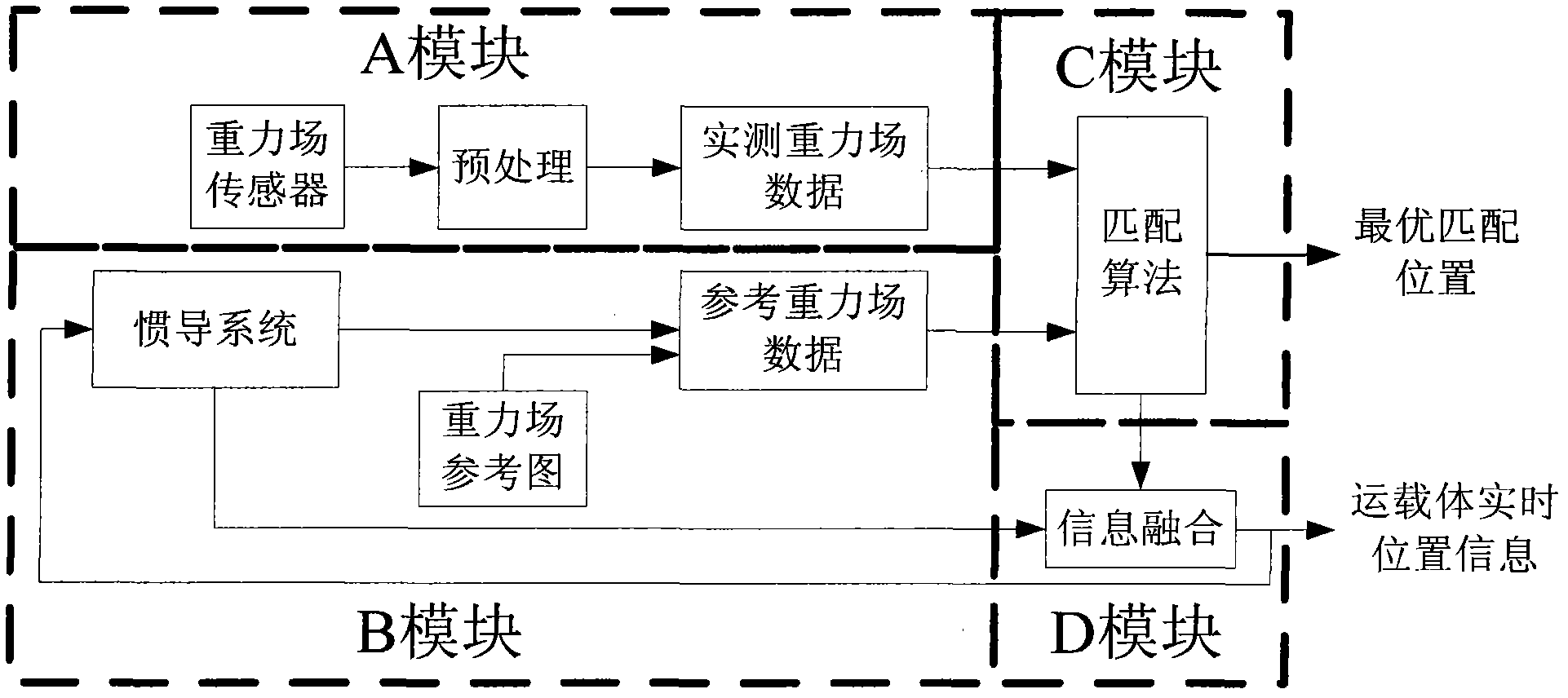
[0030] Such as figure 1 As shown, the traditional gravity-assisted inertial navigation system is generally divided into four modules: A, B, C and D. The main purpose of module A is to use the gravity field sensor carried on the carrier to measure the actual gravity field data on the carrier’s trajectory in real time; the main purpose of module B is to use the real-time data provided by the inertial navigation system on the carrier The purpose of module C is to use the matching algorithm to finally obtain the optimal position information of the carrier; the purpose of module D is to use the optimal matching position information and use information fusion technology to correct inertial data in real time. Systematic error within the guidance system.

[0031] The invention is mainly aimed at the initial alignment method of the matching algorithm in the C module, so as to improve the reliability and real-time performance of the gravity-assisted inertial navigation system.

[0032...


PUM


Abstract

The invention discloses an initial matching method for use in gravimetric map matching in a gravity-aided inertial navigation system, which comprises: according to the characteristic of high short-term measurement precision of the inertial navigation system, building a geometric constraint model by using three parameters, namely running distance information L1 and L2, which are acquired by the inertial navigation system at adjacent moments t1 and t2 and t2 and t2, of a carrier body and relative steering angle theta at the moment t2 of the carrier body; and obtaining the initial value of the gravimetric map matching by according to isolines C1, C2 and C3 corresponding to the gravity values measured by a gravity sensor at the moments t1, t2 and t3 and according to a geometric constraint isoline matching algorithm. The method is an automatic initial matching method and has the characteristics of high precision and high robustness. The method can be used for initial matching in a passive navigation system such as landform / geomagnetism / gravity-aided inertial navigation systems.

Description

technical field [0001] The invention relates to an initial matching method of a gravity map matching in a gravity-assisted inertial navigation system, and mainly aims at the initial matching method of a gravity map matching algorithm in a gravity-assisted inertial navigation system. Background technique [0002] As far as the passive navigation technology of geophysical field-assisted inertial navigation is concerned, it is not a new topic. The earliest research was on land-based terrain-assisted inertial navigation, and achieved remarkable results in the late 1970s and early 1980s. In recent years, with the help of geodetic technical achievements, the theory and method of inertial / gravity and inertial / geomagnetic passive integrated navigation have also attracted the attention of research institutions and scholars at home and abroad, and researches on gravity matching navigation and geomagnetic matching navigation have been carried out successively. . At present, the method...

Claims


Application Information

Patent Timeline
Patent Type & Authority Applications(China)
IPC IPC(8): G01C21/20G01C21/16
Inventor 朱庄生房建成
Owner BEIHANG UNIV
Why Eureka
Try Eureka