Isoline matching method for passive navigation based on triangular constraint model

A technology of constraining models and matching methods, applied in ground navigation, navigation calculation tools, etc., can solve problems such as mismatching and unavailability

Inactive Publication Date: 2011-08-31
BEIHANG UNIV
View PDF4 Cites 10 Cited by
  • Summary
  • Abstract
  • Description
  • Claims
  • Application Information

AI Technical Summary

Problems solved by technology

However, the assumption that the position error of the carrier is linearly related to the variation of the abnormal value of the geophysical field is only valid when the real position is not far from the position indicated by the inertial navigation...

Method used


Image

  • Isoline matching method for passive navigation based on triangular constraint model
  • Isoline matching method for passive navigation based on triangular constraint model
  • Isoline matching method for passive navigation based on triangular constraint model

Examples


Embodiment Construction

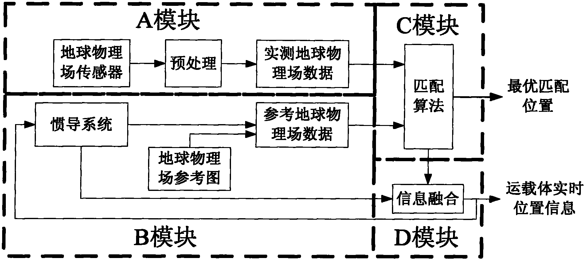
[0034] Such as figure 1 As shown, the traditional geophysical field-assisted inertial navigation system is generally divided into four modules: A, B, C and D. The main purpose of module A is to use the geophysical field sensors carried on the carrier to measure the actual geophysical field data on the carrier’s trajectory in real time; the main purpose of module B is to use the real-time data provided by the inertial navigation system carried on the carrier The position information of the carrier is combined with the reference map of the geophysical field to finally obtain the reference geophysical field data; the purpose of the C module is to use the matching algorithm to finally obtain the optimal position information of the carrier; the purpose of the D module is to use the optimal matching position information to adopt the information The fusion technology corrects the system error inside the inertial navigation system in real time.

[0035] The present invention is mainl...


PUM


Abstract

The invention provides an isoline matching method for passive navigation based on a triangular constraint model. Aiming at a passive navigation (topographical/geomagnetic/gravity auxiliary inertial navigation) system, the invention provides the method, for the purpose of quickly acquiring a high-precision initial matching value under the condition that the error of the carrier position information supplied by an inertial navigation system is large when a carrier just enters into a geophysical field adapting area. The method is characterized in that the known high precision triangular constraint model is utilized for performing the isoline matching. The method provided by the invention is an autonomous matching method, has the characteristics of high precision and excellent robustness, meets the demand of the passive navigation system geophysical field matching technique on the precision of the carrier initial position and the real-time demand of the carrier on the passive navigation system, and can be applied to initially matching in the passive navigation systems, such as topographical/geomagnetic/gravity auxiliary inertial navigation system.

Description

technical field [0001] The invention relates to geophysical field (topography / geomagnetism / gravity) assisted inertial navigation, and is mainly aimed at the initial matching method of the matching algorithm in the auxiliary navigation system. Background technique [0002] The geophysical field (terrain / magnetism / gravity) assisted navigation method is a very effective method for readjusting and correcting the errors of the inertial navigation system. It belongs to the true passive navigation, so it has received more and more attention. . For passive navigation systems, usually when entering the geophysical field navigation map adaptation area, the navigation position and heading angle output by the pure inertial navigation of the carrier after a long voyage have accumulated a large error, so , using the geophysical field information to correct the large position error of the inertial navigation system is the first problem to be solved in the geophysical field assisted inerti...

Claims


Application Information

Patent Timeline
IPC IPC(8): G01C21/20G01C21/08
Inventor 朱庄生房建成
Owner BEIHANG UNIV
Why Eureka
Try Eureka