Medium-resolution remote sensing image discrete point DEM (Digital Elevation Model) construction method based on medium value filtering

A remote sensing image and construction method technology, applied in 3D modeling, image data processing, instruments, etc., can solve the problems of difficult data source acquisition, high cost, and low measurement accuracy, so as to reduce time complexity, improve efficiency, The effect of improving the height accuracy

Inactive Publication Date: 2014-04-30
NANJING UNIV
View PDF5 Cites 0 Cited by
  • Summary
  • Abstract
  • Description
  • Claims
  • Application Information

AI Technical Summary

Problems solved by technology

[0003] At present, large-scale surface elevation information can be obtained through aviation and space remote sensing, and many surface elevation inversion methods have been formed: ①Wehr A, Axelsson P, Du Guoqing and others respectively in "Airborne laser scanning: An introduction and overview.ISPRS Journal of Photogrammetry and Remote Sensing", "Airborne laser scanning: An introduction and overview.ISPRS Journal of Photogrammetry and Remote Sensing" and "Application of LIDAR Technology in Jiangsu Coastal Beach Surveying and Mapping" articles use LiDAR (Light Detection And Ranging, airborne laser detection and ranging system) to retrieve elevation information in different areas, but since the measurement accuracy of LiDAR data in shallow water areas is not high, it needs to be corrected later; ②Akira H, Stemphen G, Rabus B, Jin Yaqiu et al. ASTER stereo image data: DEM validation and accuracy assessment", "Extraction of topography from side-looking satellite systems: A case study with SPOT simulation data", "The shuttle radar topography mission-a new class of digital elevation models acquired by spaceborne radar " and "Ground Digital Elevation (DEM) Inversion Using Synthetic Aperture Radar (SAR) Single-Flight Full-Polarization Image Data" and other articles, using stereo image pairs to invert space remote sensing image elevation information, but the data source is difficult to obtain ③ Zhang Ying et al. put forward an idea of ​​inversion of elevation information based on tidal flat water content in the article "Remote Sensing Measurement of Soil Moisture Content in Coastal Tidal Flats", and established tidal flat elevation and beach surface sediment The correlation relationship between the water content and the inversion of the water content of the beach surface sediments can approximate the tidal flat elevation. Since this method requires the actual measurement of satellite-synchronized ground tidal flat soil information, it is not easy to achieve operational operation; Research on Depth Retrieval Method of Shallow Sea Based on Satellite Data”, Tian Qingjiu in “Jiangsu Coastal Water Depth Remote Sensing Research” from the theoretical equation of radiative transfer, semi-theoretical and semi-empirical water depth remote sensing model, measured water depth The underwater terrain is retrieved from the same angle as the model related to the pixel radiation value. Due to the complex satellite imaging mechanism, the retrieval accuracy is not high

Method used


Image

  • Medium-resolution remote sensing image discrete point DEM (Digital Elevation Model) construction method based on medium value filtering
  • Medium-resolution remote sensing image discrete point DEM (Digital Elevation Model) construction method based on medium value filtering
  • Medium-resolution remote sensing image discrete point DEM (Digital Elevation Model) construction method based on medium value filtering

Examples


Embodiment 1

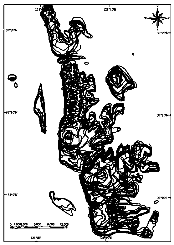
[0036] This embodiment takes the radiation sandbank in the central part of Jiangsu Province as an example. Because most of the coastal areas in the central part of Jiangsu belong to regular semi-diurnal tides, that is, there are two low tides and two high tides in one lunar day (24 hours and 25 minutes). Therefore, the daily high and low tide hours and tide height observation data of the Chenjiawu tide gauge station can be collected.

[0037] Attached figure 1 The waterline data of the remote sensing images shown are used as reference data for constructing DEM. There are 34 waterline vector files, which were acquired in 2006. All waterline data are obtained from Landsat TM, SPOT HRV, CBERS-2CCD, IRS-P6 , AWiFS / LISS, Beijing-1CCD and ERS-2SAR sensors obtained from remote sensing images. The five steps of this method are implemented under Visual Studio 2008 platform by using C# programming language, and the read and write operations of vector data are realized by the open sourc...


PUM


Abstract

The invention belongs to the field of a medium-resolution remote sensing image discrete point DEM (Digital Elevation Model) construction method, which discloses a medium-resolution remote sensing image discrete point DEM construction method based on medium value filtering. The medium-resolution remote sensing image discrete point DEM construction method comprises the following steps of: 1. calculating tidal height information at a satellite imaging moment; 2. dispersing a vector waterline extracted at the satellite imaging moment; 3. combining equidistant tidal level points dispersed in the above steps, building the reference grid of the median filtering according to a remote sensing image resolution ratio, labeling all dispersed equidistant tidal level points, and marking the ID (Identity) of the grid to which the equidistant tidal level points belong; 4. traversing all grids; and 5. on the basis of a median filtering result, building a final DEM result by linear interpolation. In the method disclosed by the invention, the method of median filtering effectively utilizes the elevation information of all discrete points falling in the grids to improve the elevation precision of the discrete point.

Description

technical field [0001] The invention relates to a method for constructing a discrete point DEM of a medium-resolution remote sensing image, more specifically, to a method for constructing a discrete point DEM of a medium-resolution remote sensing image based on a median filter. Background technique [0002] Surface elevation information is one of the basic data in geoscience research. Rapid acquisition and inversion of regional elevation information has always been a hot spot in remote sensing information inversion. On the one hand, for regions with rapid changes in surface morphology, analyzing the geomorphological elevation information in different time periods can obtain the evolution characteristics and laws of regional geomorphology, which can provide scientific decision-making basis for the coordinated development of economic society and natural environment; On the other hand, due to the muddy beach surface, dense tidal trenches, variable tidal flat erosion and silting...

Claims


Application Information

Patent Timeline
Patent Type & Authority Patents(China)
IPC IPC(8): G06T17/05
Inventor 刘永学李满春程亮蔡文婷陈焱明胡炜童礼华李真杨康张雯
Owner NANJING UNIV
Why Eureka
Try Eureka