Multi-level mixed three-dimensional space index method

A three-dimensional, multi-level technology, applied in special data processing applications, instruments, electrical and digital data processing, etc., can solve the problems of different sizes, different target shapes, complex indoor semantic topological relationships, etc., and achieve fast filtering and indexing. Effect

Active Publication Date: 2013-05-08
SHENZHEN INST OF ADVANCED TECH
View PDF2 Cites 15 Cited by
  • Summary
  • Abstract
  • Description
  • Claims
  • Application Information

AI Technical Summary

Problems solved by technology

[0002] In 3D GIS, tens of thousands of 3D space objects such as buildings, pipelines, and geological bodies above and below ground are distributed unevenly in 3D space. How to efficiently query 3D space objects that meet specified spatial conditions from 3D space is a traditional The two-dimensional spatial index technology is difficult to handle, and the effective support of the three-dimensional spatial index is urgently needed
Therefore, in response to the demand for integrated retrieval of various 3D spatial entities above and below the ground in large-scale 3D spatial databases, various thematic models such as architectural models, geological body models, and pipeline models have different functions in geometric shape and texture cha

Method used


Image

  • Multi-level mixed three-dimensional space index method
  • Multi-level mixed three-dimensional space index method

Examples


Embodiment Construction

[0024] The present invention will be further described in detail below in conjunction with the accompanying drawings and specific embodiments.

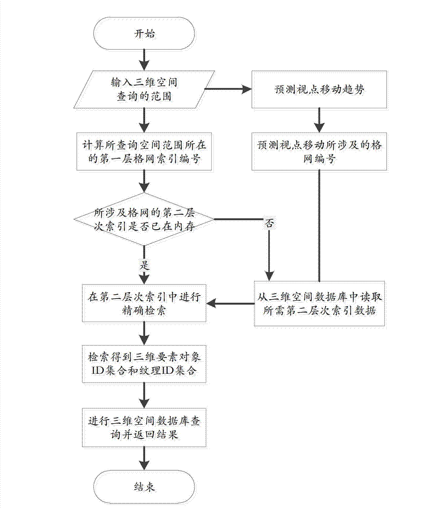
[0025] Such as figure 1 As shown, it is a flowchart of an embodiment of the multi-level mixed three-dimensional space indexing method of the present invention. The multi-level mixed three-dimensional space indexing method of the present invention includes the following steps,

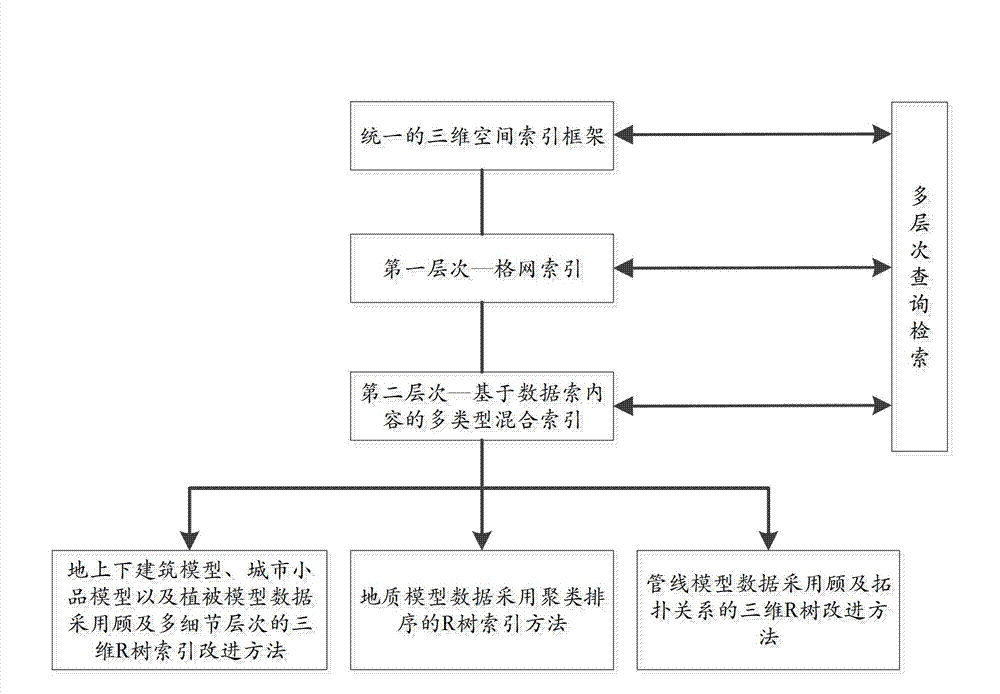
[0026] Step 1, establishing a unified three-dimensional spatial index framework;

[0027] Step 2, divide the large-scale urban space into several small areas, and establish the first-level grid index;

[0028] Step 3, in the first-level grid area, establish a second-level multi-type mixed index for different types of three-dimensional spatial data;

[0029] In step 3, the three-dimensional element data includes discretely distributed above-ground and underground building models, urban sketch models, and vegetation model data, and the above-ground and undergro...


PUM


Abstract

The invention relates to a multi-level mixed three-dimensional space index method which comprises the following steps: 1, building a united three-dimensional space index framework; 2, dividing a large-scale city space into a plurality of small regions, and building a first level grid index; 3, in the first level grid index region, building a second level multi-type mixing index for three-dimensional space data with different types; and 4, based on the multi-level mixed three-dimensional space index, carrying out multi-level query search on a three-dimensional space database. The three-dimensional space index method improves the searching efficiency of the large-scale three-dimensional space database through multi-level filter and search.

Description

technical field [0001] The invention relates to the technical field of geographic space systems, in particular to a multi-level mixed three-dimensional space indexing method. Background technique [0002] In 3D GIS, tens of thousands of 3D space objects such as buildings, pipelines, and geological bodies above and below ground are distributed unevenly in 3D space. How to efficiently query 3D space objects that meet specified spatial conditions from 3D space is a traditional The two-dimensional spatial index technology is difficult to deal with, and the effective support of the three-dimensional spatial index is urgently needed. Since the R tree spatial index method proposed by Guttma in 1984, R tree and its variants have been widely studied and applied, such as R+ tree, R* tree and HilbertR tree, and combined index methods such as QR* and LOD-OR. The current three-dimensional spatial indexing methods mainly include: object segmentation method, which is mainly realized by hi...

Claims


Application Information

Patent Timeline
IPC IPC(8): G06F17/30
Inventor 李晓明朱庆龚俊梁守真周东波彭大为
Owner SHENZHEN INST OF ADVANCED TECH
Why Eureka
Try Eureka