Simultaneous localization and mapping method and device

A technology for map construction and acquisition devices, which is applied in directions such as navigation through speed/acceleration measurement, can solve problems such as high equipment cost, high technical difficulty, interference, etc., and achieve cost saving, novel cost, real-time positioning and map construction Effect

Active Publication Date: 2013-09-25
LENOVO (BEIJING) CO LTD
4 Cites 26 Cited by

AI-Extracted Technical Summary

Problems solved by technology

However, these existing real-time positioning and mapping (SLAM) methods usually need to rely on a combination of multiple navi...

Abstract

The invention discloses a simultaneous localization and mapping method based on an inertial navigation device, and a simultaneous localization and mapping device using the simultaneous localization and mapping method. The simultaneous localization and mapping method based on the inertial navigation device comprises: recording initial characteristic point information of an initial point for placing a characteristic point information obtaining device, wherein the characteristic point information obtaining device is a moveable electronic device, and the movable electronic device comprises the inertial navigation device and a crash sensor component; moving the moveable electronic device, when the crash sensor component of the movable electronic device senses crash, determining the place generating crash to be the characteristic point, and recording the characteristic point information about the characteristic point, obtained by the inertial navigation device; based on a predetermined crash strategy, continuously moving the movable electronic device in order to obtain other characteristic point information; and mapping based on the obtained predetermined information of numbers of characteristic points.

Application Domain

Navigation by speed/acceleration measurements

Technology Topic

Mobile electronicsCharacteristic point +4

Image

  • Simultaneous localization and mapping method and device
  • Simultaneous localization and mapping method and device

Examples

  • Experimental program(1)

Example Embodiment

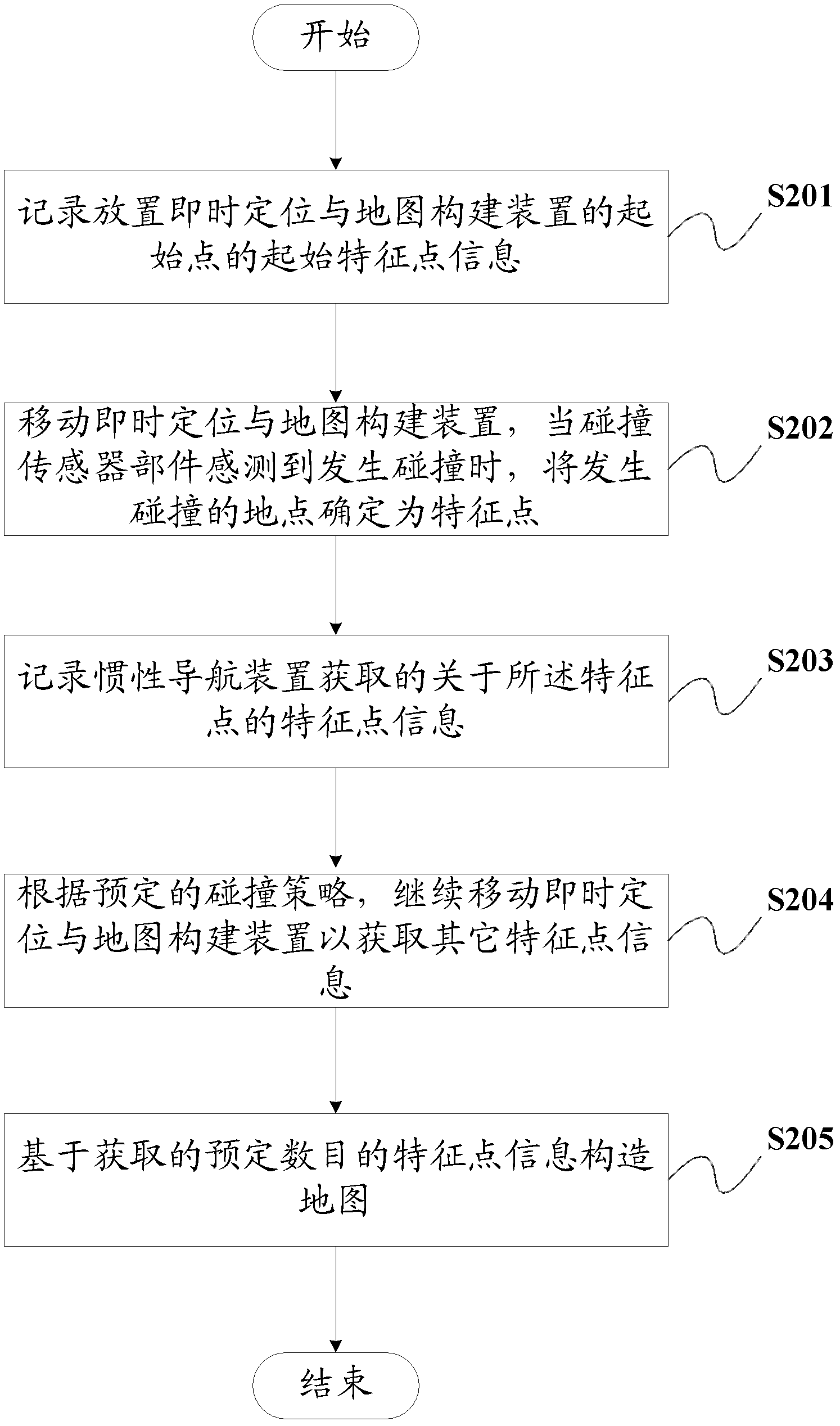
[0017] Hereinafter, preferred embodiments of the present invention will be described in detail with reference to the accompanying drawings.
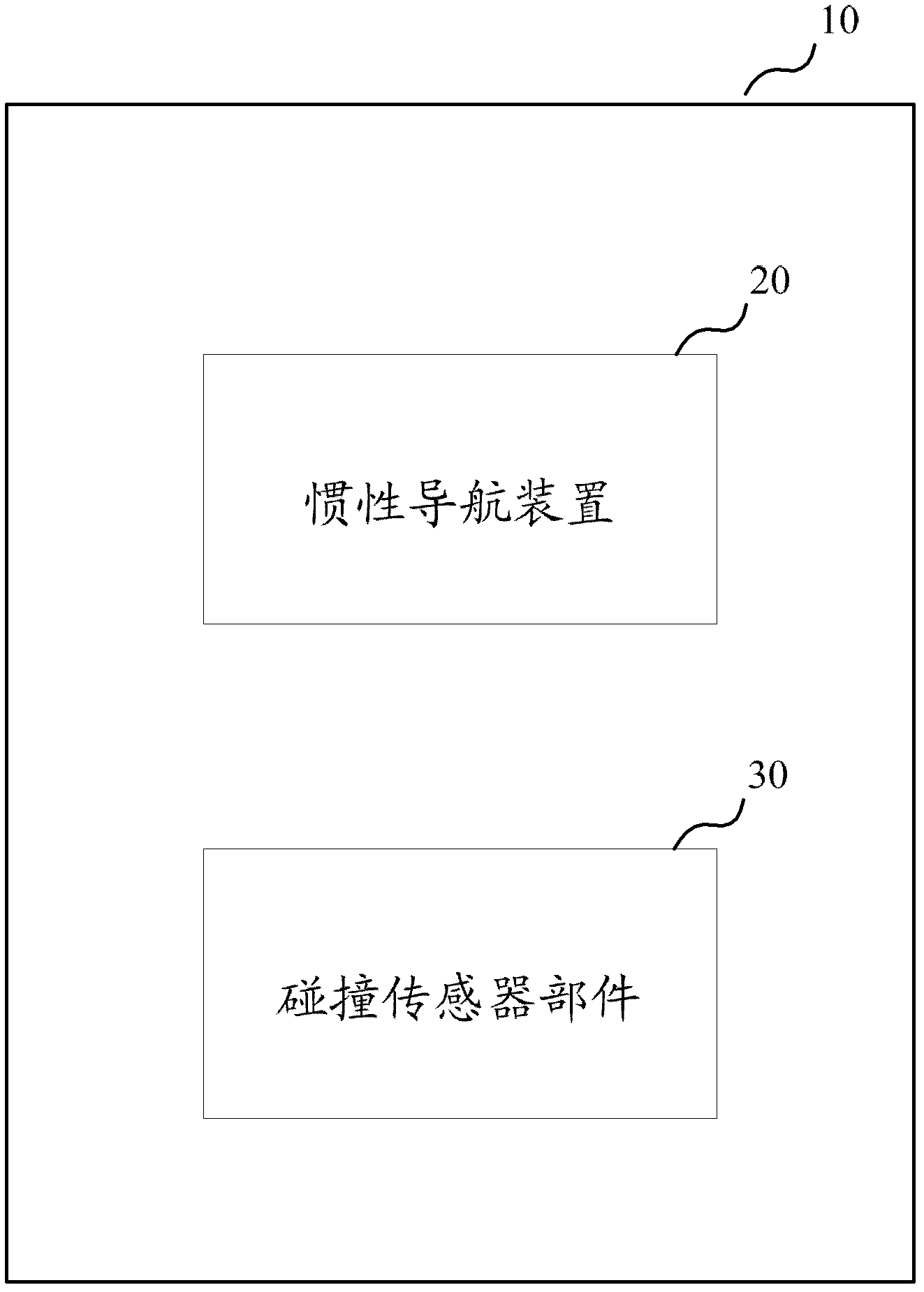
[0018] First, refer to figure 1 A real-time positioning and map building apparatus according to an embodiment of the present invention is described. The instant positioning and mapping means is preferably, for example, a mobile electronic device such as a robot.
[0019] like figure 1 As shown, the instant positioning and map construction apparatus 10 according to the embodiment of the present invention includes an inertial navigation apparatus 20 and a collision sensor component 30 .
[0020] Specifically, the inertial navigation device 20 includes a gyroscope, an accelerometer, and the like, which are used to obtain information such as movement position, attitude, and speed of the instant positioning and map construction device 10 . The inertial navigation device 20 uses a reckoning navigation method, that is, from the position of a known point, the position of the next point is calculated based on the continuously measured movement angle and velocity of the device. For example, a gyroscope is used to form a navigation coordinate system in which the measurement axis of an accelerometer is stabilized and gives heading and attitude angles. The accelerometer is used to measure the acceleration of the moving body through an integration of time to obtain the speed, and the speed can be obtained by an integration of time to obtain the distance. Wherein, the gyroscope includes, but is not limited to, a wound gyroscope, an electrostatic gyroscope, a laser gyroscope, a fiber optic gyroscope, a micromachined gyroscope, and the like. The inertial navigation device 20 used in the embodiment of the present invention has the following advantages compared to other navigation devices used in real-time localization and map building (SLAM) in the prior art: (1) Because it does not depend on any external information It is an autonomous system that does not radiate energy to the outside, so it has good concealment and is not affected by external electromagnetic interference; (2) It can provide position, speed, heading and attitude angle data, and the generated navigation information has good continuity and Low noise; (3) High data update rate, good short-term accuracy and stability; (4) Low manufacturing cost, simple data acquisition and control methods.
[0021] The collision sensor component 30 is used to sense the collision event between the instant positioning and map building apparatus 10 and the external environment. The crash sensor component 30 includes, but is not limited to, an eccentric weight sensor, a rolling ball crash sensor, a roller expansion sensor, a mercury switch crash sensor, a piezoresistive effect crash sensor, a piezoelectric effect crash sensor, and the like.
[0022] In the instant positioning and map construction apparatus 10 of the present invention, each time the collision sensor component 30 senses that the instant positioning and map construction apparatus 10 collides with the external environment, that is, the collision occurrence location is determined to be used for map construction At this time, the navigation information collected by the inertial navigation device 20 is the feature point information of the map feature point. By constructing a large number of feature points and collecting corresponding feature point information, a 2D map can be formed, so that the instant positioning and map constructing apparatus 10 (eg, a robot) can navigate according to the formed map.
[0023] Refer to the above figure 1 The instant positioning and map building apparatus 10 according to the embodiment of the present invention is described. Hereinafter, the real-time positioning and map construction method performed by the real-time positioning and map construction apparatus 10 according to the embodiment of the present invention will be further described in detail.
[0024] figure 2 It is a flow chart illustrating a method for instant positioning and map construction according to an embodiment of the present invention.
[0025] like figure 2 As shown, the real-time positioning and map construction method according to the embodiment of the present invention includes:
[0026] In step S201, the starting feature point information of the starting point where the instant positioning and map building apparatus 10 is placed is recorded. Thereafter, the real-time positioning and map building method proceeds to step S202.
[0027] In step S202, the real-time positioning and map construction apparatus 10 is moved, and when the collision sensor component 30 of the real-time positioning and map construction apparatus 10 senses a collision, the location of the collision is determined as a feature point. Thereafter, the real-time positioning and map building method proceeds to step S203.
[0028] In step S203, the feature point information about the feature points acquired by the inertial navigation device 20 is recorded. Thereafter, the real-time positioning and map building method proceeds to step S204.
[0029]In step S204, according to a predetermined collision strategy, continue to move the real-time positioning and map building apparatus 10 to obtain other feature point information. In a preferred embodiment of the present invention, the predetermined collision strategy includes: when the collision sensor component 30 of the instant positioning and map building apparatus 10 senses a collision, the instant positioning and map building apparatus 10 will Perform intelligent analysis to determine further movement patterns. For example, the real-time positioning and map building apparatus 10 may choose to retreat more than 0 and less than 20 centimeters and rotate to the right or left by 1-10° according to the specific environment pattern in which it is located. When the instant positioning and map building apparatus 10 is in a narrow space, the instant positioning and map building apparatus 10 may choose to retreat more than 0 and less than 2 cm. Further, when the re-collision points after three consecutive rotations of 1° are all on the same plane, the instant positioning and map building apparatus 10 selects a larger rotation angle, for example, a rotation angle of 2° or even 10°. In addition, if the instant positioning and map building apparatus 10 cannot move forward according to the strategy or collide back and forth between 3 faces of a small space for a certain period of time (eg, 20 seconds and more), the instant positioning is performed. A strategy for returning the nearest valid point (eg, to the nearest feature point of the three faces) with the map construction device 10 . That is to say, the instant positioning and map building apparatus 10 will proceed according to the reverse strategy (ie, adopting the strategy of rotating in the opposite direction from the previous time at this effective feature point). Specifically, in a preferred embodiment of the present invention, the predetermined collision strategy includes that when a collision occurs, the instant positioning and map construction device 10 moves backward by 5 cm and rotates 1° to the right to continue forward. In another preferred embodiment of the present invention, the predetermined collision strategy further includes that when the instant positioning and map building device 10 cannot continue to move, the instant positioning and map building device 10 returns to the starting point. Thereafter, the real-time positioning and map building method proceeds to step S205.
[0030] In step S205, a map is constructed based on the acquired predetermined number of feature point information. In a preferred embodiment of the present invention, the predetermined number of feature points may be 1000 feature points, but the present invention is of course not limited thereto.
[0031] Refer to the above figure 1 and figure 2 A real-time positioning and map construction method based on an inertial navigation device and a real-time positioning and map construction device using the real-time positioning and map construction method according to embodiments of the present invention are described, which realize novel and cost-saving real-time positioning and map construction.
[0032] It should be noted that, in this specification, the terms "comprising", "comprising" or any other variation thereof are intended to encompass non-exclusive inclusion, such that a process, method, article or device comprising a series of elements includes not only those elements , but also other elements not expressly listed or inherent to such a process, method, article or apparatus. Without further limitation, an element qualified by the phrase "comprising a..." does not preclude the presence of additional identical elements in a process, method, article or apparatus that includes the element.
[0033] Finally, it should also be noted that the above series of processing includes not only processing performed in time series in the order described here, but also processing performed in parallel or separately, rather than in time series.
[0034] From the description of the above embodiments, those skilled in the art can clearly understand that the present invention can be implemented by means of software plus a necessary hardware platform, and certainly can also be implemented entirely by hardware. Based on this understanding, all or part of the technical solutions of the present invention can be embodied in the form of software products, and the computer software products can be stored in storage media, such as ROM/RAM, magnetic disks, optical disks, etc. , including several instructions for causing a computer device (which may be a personal computer, a server, or a network device, etc.) to perform the methods described in various embodiments or some parts of the embodiments of the present invention.
[0035] The present invention has been introduced in detail above, and the principles and implementations of the present invention are described in this paper by using specific examples. The description of the above embodiments is only used to help understand the method and the core idea of ​​the present invention; According to the idea of ​​the present invention, a person of ordinary skill in the art will have changes in the specific embodiments and application scope. In conclusion, the content of this specification should not be construed as a limitation of the present invention.

PUM

no PUM

Description & Claims & Application Information

We can also present the details of the Description, Claims and Application information to help users get a comprehensive understanding of the technical details of the patent, such as background art, summary of invention, brief description of drawings, description of embodiments, and other original content. On the other hand, users can also determine the specific scope of protection of the technology through the list of claims; as well as understand the changes in the life cycle of the technology with the presentation of the patent timeline. Login to view more.

Similar technology patents

Material including graphene and an inorganic material and method of manufacturing the material

ActiveUS20110129675A1reduce defectlow cost
Owner:SAMSUNG ELECTRONICS CO LTD +1

Haptic trackball device

InactiveUS7710399B2simple actuatorlow cost
Owner:IMMERSION CORPORATION

Mobile authentication for network access

ActiveUS20060069916A1low cost
Owner:ALCATEL LUCENT SAS
Why Eureka
Try Eureka