Ancient lake depth measuring method

A technology of lake water and lakes, which is applied in the field of measuring the water depth of ancient lakes, can solve the problems of random parameter selection, inconvenience, and complicated depth of ancient lakes, etc., and achieve the effects of avoiding random parameter selection, simple calculation, and solving difficult calculations

Inactive Publication Date: 2013-10-09
CHINA UNIV OF GEOSCIENCES (BEIJING)
View PDF4 Cites 28 Cited by
  • Summary
  • Abstract
  • Description
  • Claims
  • Application Information

AI Technical Summary

Problems solved by technology

[0028] It can be seen from the above steps that it is very difficult to calculate the water depth of ancient lakes by using the corrugation empirical method, and the selection of parameters is very random. In addition, it is very inconvenient to transport sediments for measurement.

Method used


Image

  • Ancient lake depth measuring method
  • Ancient lake depth measuring method
  • Ancient lake depth measuring method

Examples


Embodiment Construction

[0041] The present invention will be described in further detail below through specific implementation examples and in conjunction with the accompanying drawings.

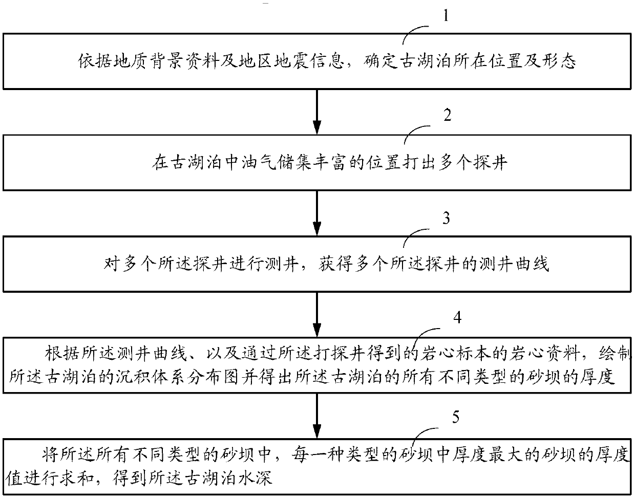
[0042] The embodiment of the present invention provides a method for measuring the water depth of ancient lakes, as shown in the figure, the method includes the following steps:

[0043] A method for determining the water depth of a paleolake, comprising:

[0044] Step 1: Determine the location and shape of the ancient lake based on geological background data and regional earthquake information;

[0045] Step 2: Drill multiple exploratory wells at positions rich in oil and gas reserves in ancient lakes;

[0046] Step 3: Logging multiple exploratory wells to obtain logging curves of multiple exploratory wells;

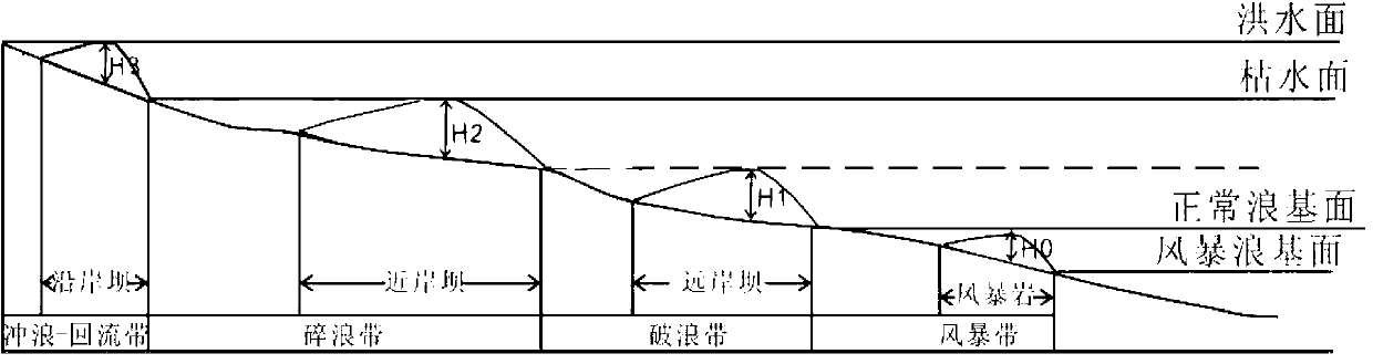
[0047] Step 4 draws the distribution map of the sedimentary system of the ancient lake according to the well logging curve and the core data of the core samples obtained through the drilling well and obtai...


PUM


Abstract

The invention relates to the field of mining, in particular to an ancient lake depth measuring method. The method includes the steps of (1) confirming the position and the shape of an ancient lake according to geological background information and regional earthquake information, (2) drilling a plurality of exploratory wells in the position where oil reservoir is rich in the ancient lake, (3) detecting the exploratory wells, and obtaining well logging curves of the exploratory wells, (4) drawing a sedimentary system distribution map of the ancient lake according to the well logging curves and rock core information of rock core specimens obtained from the drilled exploratory wells, and obtaining the thicknesses of sandbanks of different types in the ancient lake, and (5) summing the thickness values of the sandbanks with the maximum thickness in all types of the sandbanks, and obtaining the depth of the ancient lake. According to the method, in measuring of the depth of the ancient lake, the number of transported sediments does not need to be calculated, procedures are few, calculation is simple, the problem that the calculation is complex by means of a ripple mark empirical formula method is solved, and the problem that randomness of parameter selection in the ripple mark empirical formula method is large is avoided.

Description

technical field [0001] The invention relates to the field of mining, in particular to a method for measuring the water depth of ancient lakes. Background technique [0002] Petroleum is produced in the sediments of ancient lakes or oceans, commonly known as "paleowaters", where oil fields are also formed. Modern oil formation theory holds that 97% of today's oil and gas reservoirs are formed in sedimentary basins where ancient lakes are located, and the age of sedimentary basins is about 20 to 500 million years. In other words, most of the oil and gas were buried in watery environments from 500 million to 20 million years ago. These watery environments are ancient lakes or ancient oceans. Ancient lakes are the main oil and gas resources in my country. Therefore, the study of the water depth of ancient lakes It is an important condition for judging the accumulation of oil and gas resources, and it has important practical significance for the prediction, evaluation, exploratio...

Claims


Application Information

Patent Timeline
Patent Type & Authority Applications(China)
IPC IPC(8): G01V9/00
Inventor 姜在兴张元福张海英王俊辉
Owner CHINA UNIV OF GEOSCIENCES (BEIJING)
Why Eureka
Try Eureka