
Analysis method and device for mine space

A mine and space technology, applied in the field of spatial data organization, can solve problems such as the actual situation that cannot be well satisfied with spatial analysis, and achieve the effect of reliability, data form, and convenient data form.

Active Publication Date: 2017-04-05
CHINA TOPRS TECH
View PDF6 Cites 0 Cited by
  • Summary
  • Abstract
  • Description
  • Claims
  • Application Information

AI Technical Summary

Problems solved by technology

[0010] The purpose of the embodiments of the present invention is to provide a mine space analysis method and device to solve the problem that the above-mentioned three-dimensional space data model organization method cannot better meet the actual situation of the space analysis of the large scene range of the entire mine

Method used


Image

  • Analysis method and device for mine space
  • Analysis method and device for mine space
  • Analysis method and device for mine space

Examples


Embodiment Construction

[0025] Hereinafter, the present invention will be described in detail with reference to the drawings and examples. It should be noted that, in the case of no conflict, the embodiments in the present application and the features in the embodiments can be combined with each other.

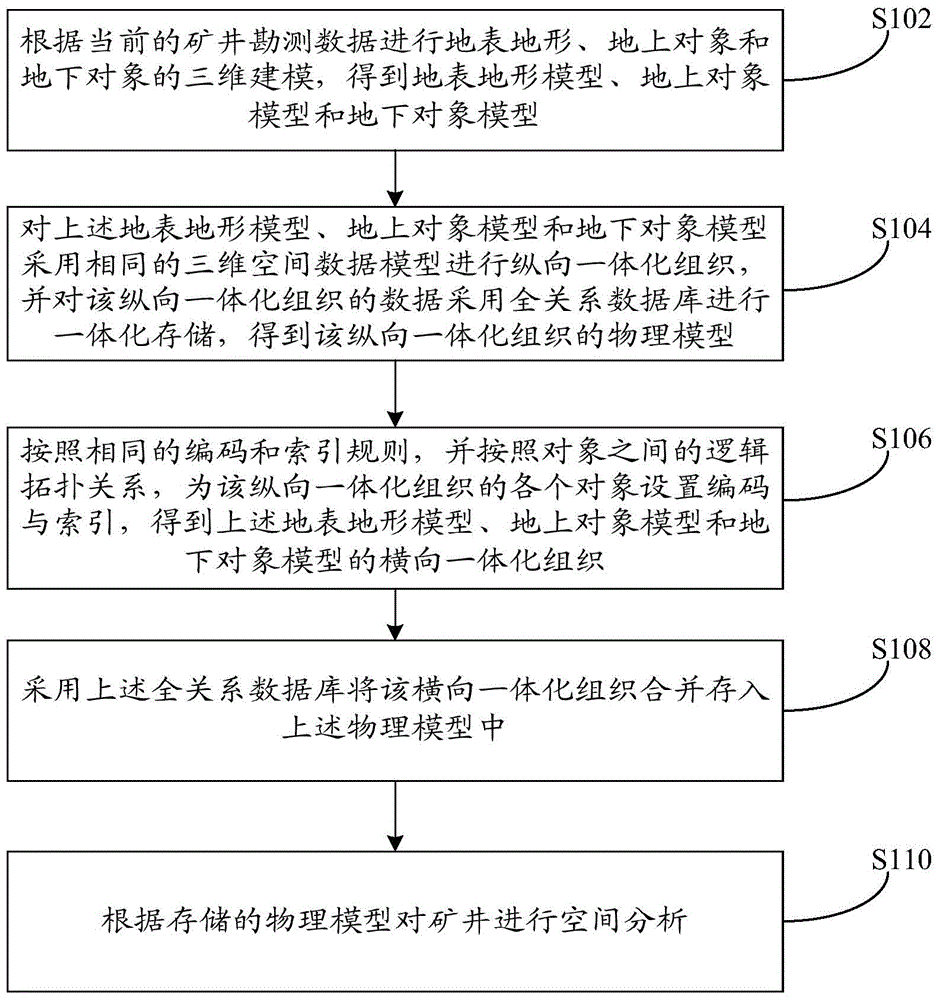
[0026] Such as figure 1 The flow chart of the analysis method of the mine space shown, the method includes the following steps:

[0027] Step S102, performing three-dimensional modeling of surface terrain, aboveground objects, and underground objects according to the current mine survey data, to obtain a surface terrain model, an aboveground object model, and an underground object model;

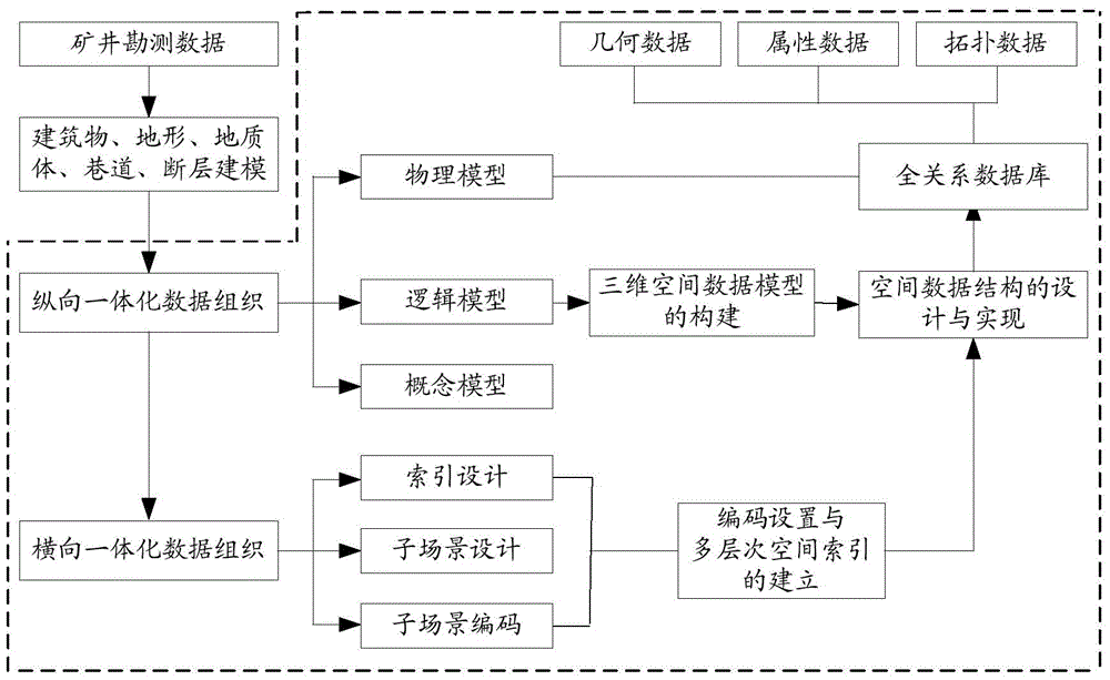
[0028] Step S104, use the same three-dimensional spatial data model for the above-mentioned surface terrain model, above-ground object model and underground object model to carry out vertical integration organization, and use the full relational database for integrated storage of the data of the vertical integrati...


PUM


Abstract

The invention discloses a method and a device for analyzing a space of a mine. The method comprises the following steps: according to current mine survey data, carrying out three-dimensional modeling to obtain a surface topography model, a ground object model and an underground object model; carrying out longitudinal integrated organization operation on the surface topography model, the ground object model and the underground object model by adopting the same three-dimensional space data model and carrying out integrated storage on data of a longitudinal integrated organization by adopting a universal relation database to obtain a physical model; according to the same encoding and indexing rules and a logic topological relation between objects and setting a code and an index for each object of the longitudinal integrated organization to obtain transverse integrated organizations; merging and storing the transverse integrated organizations into the physical model by adopting the universal relation database; and according to the stored physical model, carrying out space analysis on the mine. The invention solves the problem that an existing three-dimensional space data model organization method cannot well meet the requirement on space analysis on the whole mine in a large-scene range.

Description

technical field [0001] The invention relates to the field of spatial data organization methods, in particular to a mine space analysis method and device. Background technique [0002] Before the mine is mined, geological prospecting methods are usually used to obtain geological condition data of the mining area. These data mainly include surface and underground exploration data, such as geological topographic maps, well-up and down contrast maps, geological profile maps, drilling maps, etc. However, these data are usually two-dimensional data, and there are the following problems: 1) From the perspective of expression: it is impossible to completely and intuitively reflect the distribution of three-dimensional space objects on the ground, surface and underground of the mine, as well as the spatial relationship between the upper and lower layers and each other; 2) From the perspective of analysis: it cannot meet the three-dimensional space analysis of mine emergency rescue (s...

Claims


Application Information

Patent Timeline
Patent Type & Authority Patents(China)
IPC IPC(8): G06F17/50G06Q50/02
Inventor 李英成任丽艳王恩泉胡特彧刘洪岐
Owner CHINA TOPRS TECH
Learn More