Remote positioning method for automatically compensating magnetic declination angle

A technology of remote positioning and magnetic declination, which is applied in the directions of measuring devices, surveying and navigation, instruments, etc., and can solve problems such as inability to realize remote positioning

Active Publication Date: 2014-04-02
11TH RES INST OF CHINA ELECTRONICS TECH GROUP CORP
View PDF6 Cites 13 Cited by
  • Summary
  • Abstract
  • Description
  • Claims
  • Application Information

AI Technical Summary

Problems solved by technology

[0003] In view of the above analysis, the present invention aims to provide a remote positioning method that automatically compensates the magnetic declination to solve the problem that the handheld reconnaissance equipment in the prior art cannot achieve remote positioning

Method used


Image

  • Remote positioning method for automatically compensating magnetic declination angle
  • Remote positioning method for automatically compensating magnetic declination angle

Examples


Embodiment Construction

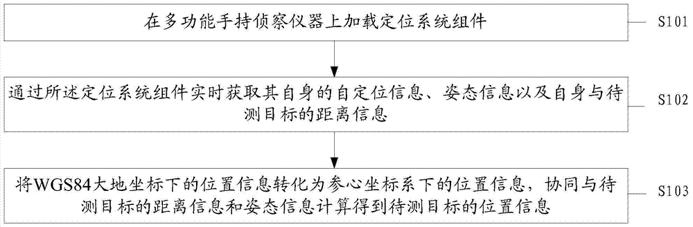
[0022] Preferred embodiments of the present invention will be specifically described below in conjunction with the accompanying drawings, wherein the accompanying drawings constitute a part of the application and are used together with the embodiments of the present invention to explain the principle of the present invention. For the sake of clarity and simplicity, detailed descriptions of known functions and constructions in the devices described herein will be omitted when it may obscure the subject matter of the present invention.

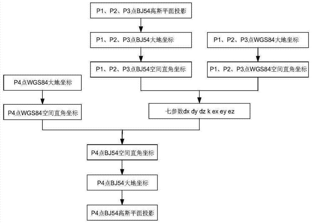
[0023] The main purpose of the embodiments of the present invention is to provide a remote positioning method that automatically compensates for magnetic declination. The positioning system component is loaded on the multi-functional handheld reconnaissance instrument, and its own self-positioning information and attitude information are obtained in real time through the positioning system component. And the distance information between itself an...


PUM


Abstract

The invention discloses a remote positioning method for automatically compensating a magnetic declination angle. The remote positioning method comprises the following steps: loading a positioning system assembly on a multifunctional hand-held reconnaissance device; obtaining self-positioning information of the multifunctional hand-held reconnaissance device, gesture information of the multifunctional hand-held reconnaissance device and distance information between the multifunctional hand-held reconnaissance device and a to-be-measured object by the positioning system assembly in real time, wherein the self-positioning information comprises one or two of position information and time information under WGS (Wide-Band Satellite) 84 geodetic coordinates; and converting the position information under the WGS84 geodetic coordinates into position information under a reference coordinate system, and cooperating distance information and gesture information of the to-be-measured object, and calculating so as to obtain position information of the to-be-measured object. The method disclosed by the invention can conveniently and simply realize the remote positioning of the hand-held reconnaissance device.

Description

technical field [0001] The invention relates to the technical field of infrared testing, in particular to a remote positioning method for automatically compensating magnetic declination. Background technique [0002] At present, the development and use of multifunctional thermal imagers at home and abroad are still in their infancy. This type of instrument belongs to the combination of traditional photoelectric products and navigation and positioning technology, and this technology is a key technology in this field. This technical solution is currently mainly used in the vehicle-mounted and airborne remote positioning methods. The embedded software and hardware environment is used as the platform. The handheld device has the advantages of low power consumption, miniaturization and light weight. Therefore, how to realize the remote positioning of the handheld device The method to meet the remote positioning function requirements in the battlefield environment has become an ur...

Claims


Application Information

Patent Timeline
Patent Type & Authority Applications(China)
IPC IPC(8): G01C21/06
CPCG01C21/00G01C21/06G01C21/08
Inventor 陈盈安成斌叶怀胜殷金坚
Owner 11TH RES INST OF CHINA ELECTRONICS TECH GROUP CORP
Why Eureka
Try Eureka