
Adaptive Filtering Method and Filter for Airborne Inertial/Satellite Integrated Navigation System

A technology of integrated navigation system and inertial navigation system, which is applied in the field of navigation, can solve the problem of self-adaptive estimation of system state noise, etc., and achieve the effect of improving the accuracy of error compensation

Active Publication Date: 2017-05-24
ELECTRIC POWER RES INST OF GUANGDONG POWER GRID +1
View PDF2 Cites 1 Cited by
  • Summary
  • Abstract
  • Description
  • Claims
  • Application Information

AI Technical Summary

Problems solved by technology

However, it can be seen that these methods do not adaptively estimate the system state noise

Method used


Image

  • Adaptive Filtering Method and Filter for Airborne Inertial/Satellite Integrated Navigation System
  • Adaptive Filtering Method and Filter for Airborne Inertial/Satellite Integrated Navigation System
  • Adaptive Filtering Method and Filter for Airborne Inertial/Satellite Integrated Navigation System

Examples


Embodiment Construction

[0029] In order to make the purpose, technical solution and advantages of the present invention more clear, the present invention will be further described in detail below in conjunction with the accompanying drawings and embodiments. It should be understood that the specific embodiments described here are only used to explain the present invention, and do not limit the protection scope of the present invention.

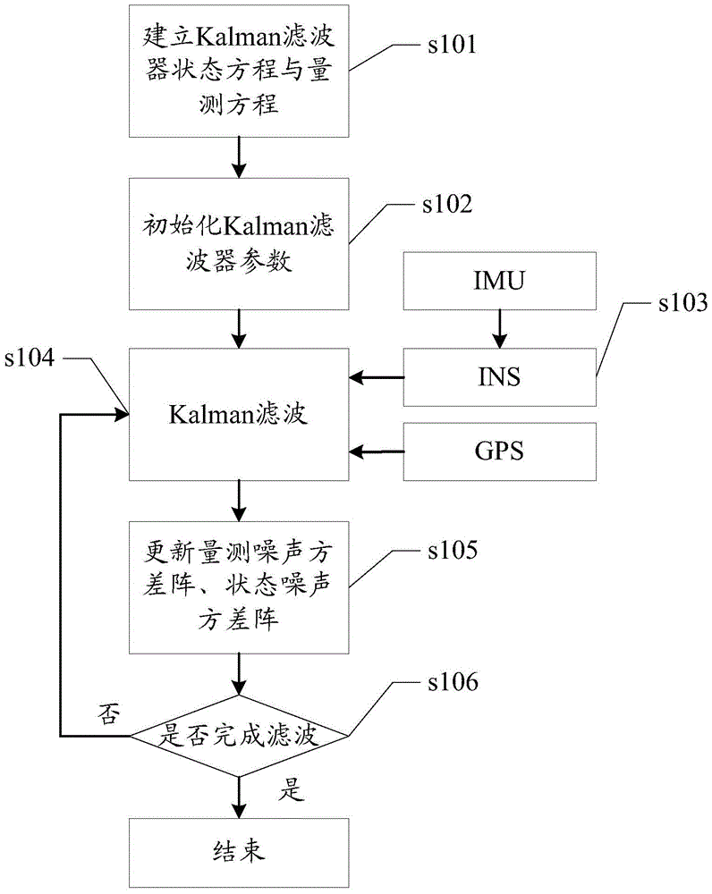
[0030] Such as figure 1 Shown, the specific steps of the adaptive filtering method of the airborne inertial / satellite integrated navigation system of the present invention are as follows:

[0031] Step s101: Establish the error model of the inertial navigation system (INS), as the state equation of the Kalman filter of the INS / GPS combined system, take the position difference and speed difference between the INS and GPS as the measurement, and establish the measurement equation of the filter, respectively as follows

[0032]

[0033] where the state vector is X ...


PUM


Abstract

The invention discloses an adaptive Kalman filtering method of an onboard inertia / satellite integrated navigation system and a filter. A state noise variance array and a measurement noise variance array are updated in real time through a state estimation error and a measurement error in the filtering process, and therefore the adaptive change of internal state information and external measurement information of the system is achieved. The method has the advantages of being moderate in calculation amount, high in estimation accuracy and the like so that adaptive adjustment of Kalman filter parameters can be achieved, and therefore the navigation and measurement accuracy of the system is improved.

Description

technical field [0001] The invention relates to the technical field of navigation, in particular to an adaptive filtering method and a filter of an airborne inertial / satellite integrated navigation system. Background technique [0002] INS / GPS (Inertial Navigation System / Global Positioning System, Inertial / Satellite Integrated Navigation System) is an accurate carrier navigation and motion parameter measurement system, which has the advantages of good reliability, high precision, and many types of output parameters. It is used in the aviation field Has been widely used. The commonly used INS and GPS data fusion algorithm is the Kalman (Kalman) filter, which can realize the optimal estimation of the system state under the condition of known system noise statistical characteristics. [0003] However, a large number of engineering practices have shown that in the airborne environment, the inertial sensors in the INS are susceptible to the influence of temperature, electromagne...

Claims


Application Information

Patent Timeline
Patent Type & Authority Patents(China)
IPC IPC(8): G01S19/49G06F19/00
CPCG01C21/165G01C21/20G01S19/49
Inventor 麦晓明郭佳王柯朱庄生饶章权彭向阳
Owner ELECTRIC POWER RES INST OF GUANGDONG POWER GRID
Learn More