A method for detecting ship targets on the sea surface

A target detection and ship technology, applied in the detection field, can solve the problems of low positioning accuracy, poor positioning accuracy, and slow speed of sea and land boundaries, and achieve the effect of avoiding invalid pixels and good separation of sea surface targets

Active Publication Date: 2017-01-11
UNIVERSITY OF CHINESE ACADEMY OF SCIENCES
View PDF4 Cites 2 Cited by
  • Summary
  • Abstract
  • Description
  • Claims
  • Application Information

AI Technical Summary

Problems solved by technology

When dealing with high-definition, complex background, and rich-detail remote sensing images, the automatic segmentation method of sea and land templates based on threshold segmentation has problems such as low positioning accuracy of sea and land boundaries, and holes are prone to appear in sea and land areas; while the automatic segmentation of sea and land templates based on texture segmentation The speed of texture feature extraction is very slow, and there are also problems of poor positioning accuracy, and holes are prone to appear in sea and land areas.
Therefore, for high-definition remote sensing images with complex sea and land backgrounds and rich details, the existing sea and land template segmentation methods based on threshold segmentation and texture segmentation often cannot obtain ideal results, and the existing detection methods cannot be quickly and accurately realized. Detection of ship targets on the sea surface in high-definition remote sensing images under complex sea and land backgrounds

Method used


Image

  • A method for detecting ship targets on the sea surface
  • A method for detecting ship targets on the sea surface
  • A method for detecting ship targets on the sea surface

Examples


Embodiment Construction

[0017] The present invention will be described in detail below in conjunction with the accompanying drawings and embodiments.

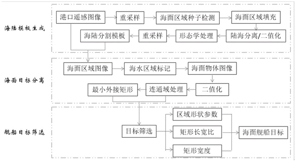
[0018] Such as figure 1 Shown, sea surface warship target detection method of the present invention comprises the following steps (as figure 1 shown):

[0019] 1) Using the sea-land template automatic segmentation method based on scan line detection to generate a sea-land segmentation template of the same size as the original remote sensing image, which includes:

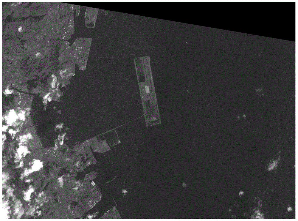
[0020] ① Input the high-resolution visible light port remote sensing image to be detected (such as figure 2 Shown), carry out resampling processing according to the resampling processing method related to the pixel area in the prior art;

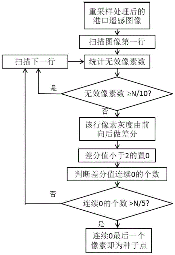
[0021] ②Aiming at the port remote sensing image after resampling processing, the sea surface area seed point detection method based on the scan line is used to detect the sea surface area seed point, and the process is as follows (such as image 3 sh...


PUM


Abstract

The invention relates to a sea surface vessel target detection method which comprises the following steps that (1) a sea-land template automatic partitioning method based on scanning line detecting is used, and a sea-land partitioning template with the same size as an original remote sensing image is generated; (2) the sea-land partitioning template is used for being matched with an original port remote sensing image, and a minimum enclosing rectangle of each communication zone is obtained; and (3) the minimum enclosing rectangles of the communication zones obtained from the step (2) are subjected to screening, and a sea surface vessel target is determined. According to the sea surface vessel target detection method, the obtained sea-land partitioning template is matched with the original remote sensing image, sea surface target separation can be well carried out, sea surface vessel target detection is achieved quickly and accurately, the method is suitable for quick extraction of high-definition remote sensing images under a complex sea-land background, and the problem of invalid pixels caused by image correction in the prior art is avoided. The sea surface vessel target detection method can be widely used in a sea surface vessel target detection process in high-definition port remote sensing images in various civil and military fields.

Description

technical field [0001] The invention relates to a detection method, in particular to a sea surface ship target detection method based on an automatic sea and land template segmentation method of scanning line detection. Background technique [0002] Ship target detection using remote sensing data has great practical significance in both civil and military fields. With the continuous enhancement of data acquisition ability and resolution of remote sensing images, the utilization and development of remote sensing image interpretation technology is imminent. Based on the researches that have been carried out at home and abroad, the ship detection process based on optical remote sensing images mainly includes three main steps: preprocessing (sea and land segmentation, cloud and fog removal, etc.), target candidate area extraction, and false alarm target removal. Among them, the segmentation of sea and land templates is an important preprocessing method, that is, the automatic s...

Claims


Application Information

Patent Timeline
Patent Type & Authority Patents(China)
IPC IPC(8): G06T7/00
Inventor 吕科张毅飞潘卫国董继阳代双凤翟锐
Owner UNIVERSITY OF CHINESE ACADEMY OF SCIENCES
Why Eureka
Try Eureka