Satellite laser altimeter directional angle system error calibration method based on directional angle residual error

A laser altimeter, system error technology, applied to radio wave measurement systems, instruments, etc., can solve the problems of correcting laser pointing angle systems, not giving, errors, etc.

Active Publication Date: 2016-11-16
WUHAN UNIV
View PDF4 Cites 23 Cited by
  • Summary
  • Abstract
  • Description
  • Claims
  • Application Information

AI Technical Summary

Problems solved by technology

However, for the inspection method of the laser pointing angle accuracy of the ground detection laser spot, the existing literature only introduces the method of detecting the laser spot, and evaluates the accuracy of the laser pointing angle through...

Method used


Image

  • Satellite laser altimeter directional angle system error calibration method based on directional angle residual error
  • Satellite laser altimeter directional angle system error calibration method based on directional angle residual error
  • Satellite laser altimeter directional angle system error calibration method based on directional angle residual error

Examples


Embodiment Construction

[0041] In order to make the object, technical solution and advantages of the present invention clearer, the present invention will be further described in detail below in combination with specific implementation cases and with reference to the accompanying drawings.

[0042] The invention provides a method for calibrating the pointing angle system error of a spaceborne laser altimeter based on the pointing angle residual. The pointing angle residual is generated by using ground light spot detection, and the pointing angle of the altimeter system is corrected using a pointing angle error calibration model. System errors are checked on-track. During specific implementation, computer software technology can be used to realize the automatic operation process. The embodiment process includes the following steps:

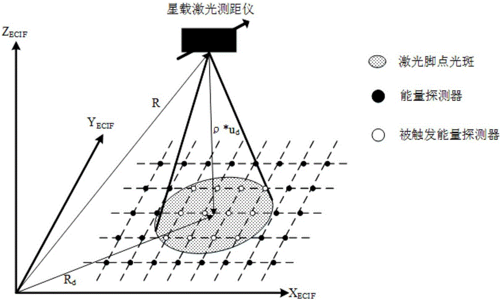
[0043] Step 1. On the premise that the laser spot is detected on the ground, establish the pointing angle residual of the spaceborne laser altimeter.

[0044] The essence...


PUM


Abstract

The invention provides a satellite laser altimeter directional angle system error calibration method based on a directional angle residual error. On the basis of ground detecting a laser spot, the directional angle residual error of a satellite laser altimeter is established according to the position of a located laser spot; based on the directional angle residual error, the relation between a directional angle system error and the directional angle residual error is established; and the directional angle residual error is formed by using the directional angle measured by a satellite system and a laser directional angle calculated by ground spot detection, and the directional angle residual error is used to achieve on-orbit calibration of a satellite laser altimeter directional angle system error. The invention can well calibrate the directional angle system error.

Description

technical field [0001] The present invention relates to the technical field of on-orbit calibration of spaceborne laser altimeters, in particular to a technical scheme for calibrating pointing angle system errors of spaceborne laser altimeters based on pointing angle residuals, which is used for pointing angle systems of spaceborne laser altimeters On-orbit calibration of errors. Background technique [0002] Space-borne laser altimeter is a new type of remote sensing system that uses laser as the measurement load. It has the advantages of high ranging accuracy, wide coverage, outstanding ability to distinguish targets, and less environmental impact. The space-borne laser altimeter records the laser emission pulse emission time and the laser echo pulse reception time through the laser ranging system to obtain the time of flight (Timeof Flight, TOF) of the laser pulse, so as to obtain the laser ranging value, combined with the laser altimeter The position information of the ...

Claims


Application Information

Patent Timeline
IPC IPC(8): G01S7/497
CPCG01S7/497
Inventor 李松易洪马跃周辉郑国兴杨晋陵田昕高俊玲
Owner WUHAN UNIV
Why Eureka
Try Eureka