Automatic inversion method for single-dip faults

A fault and tendency technology, applied in the application field of geographic information technology, can solve problems such as large investment and poor efficiency

Active Publication Date: 2019-04-23
NANJING NORMAL UNIVERSITY
View PDF6 Cites 0 Cited by
  • Summary
  • Abstract
  • Description
  • Claims
  • Application Information

AI Technical Summary

Problems solved by technology

At present, on the one hand, related applications are involved, but the related work is mainly done manually by geological experts, which requires a large investment and poor efficiency, and it is urgent to carry out research on automatic fault inversion methods; on the other hand, due to the wide range of sources and With the characteristics of wide coverage and less use restrictions, it is feasible and practical to conduct fault inversion research starting from geological maps

Method used


Image

  • Automatic inversion method for single-dip faults
  • Automatic inversion method for single-dip faults
  • Automatic inversion method for single-dip faults

Examples


Embodiment Construction

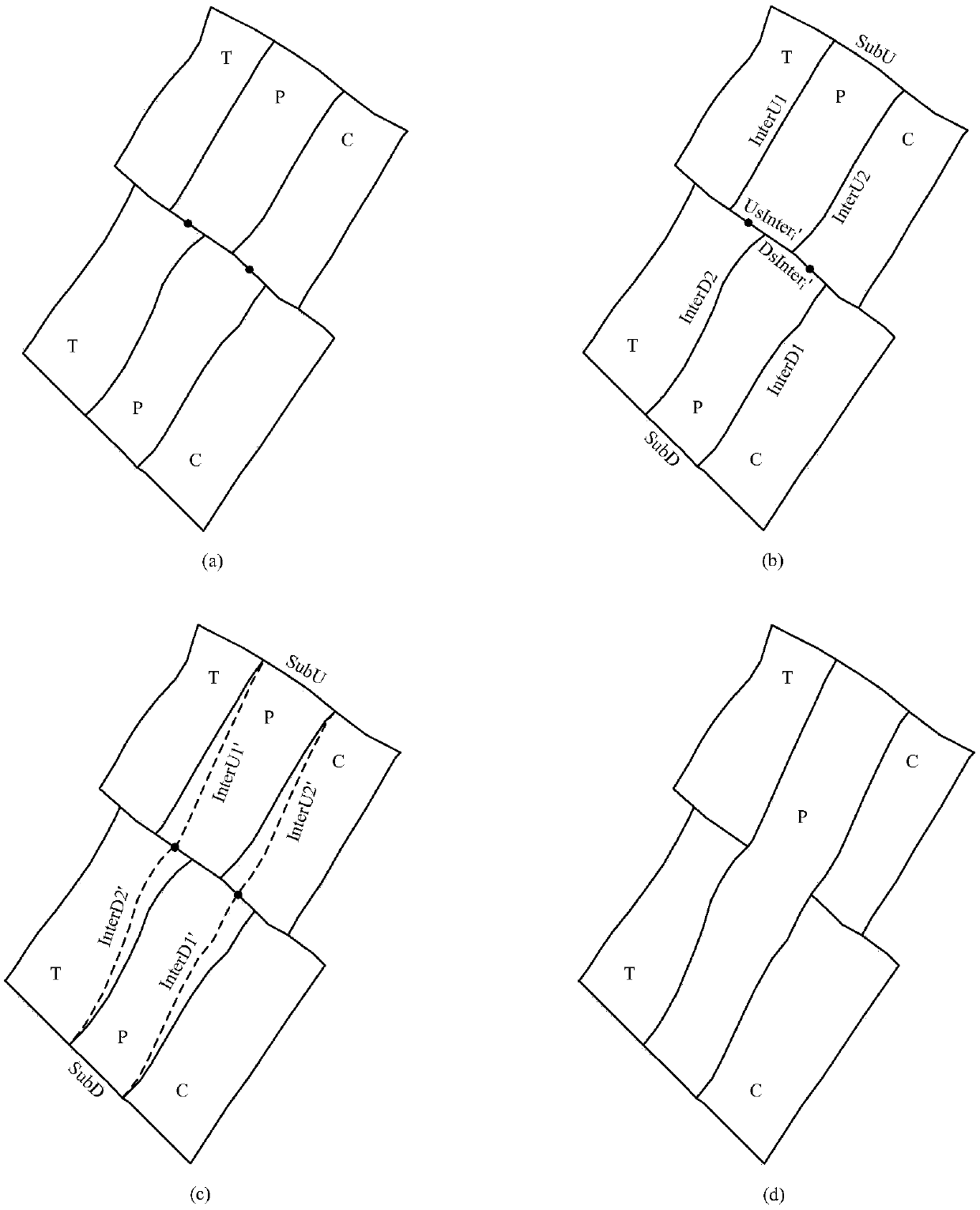
[0071] The present invention will be described in further detail below in conjunction with the embodiments and accompanying drawings.

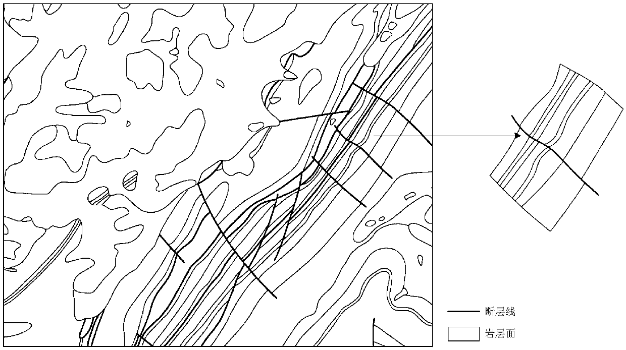
[0072] The embodiment selects 1:100000 certain regional geological map ( image 3 ) contains data for complete dipping faults. Below combined with the accompanying drawings, based on the rock layer and fault line layer in shp format ( Figure 4 ), describe an example of automatic inversion of a single-dip fault, to further illustrate the effect of the present invention.

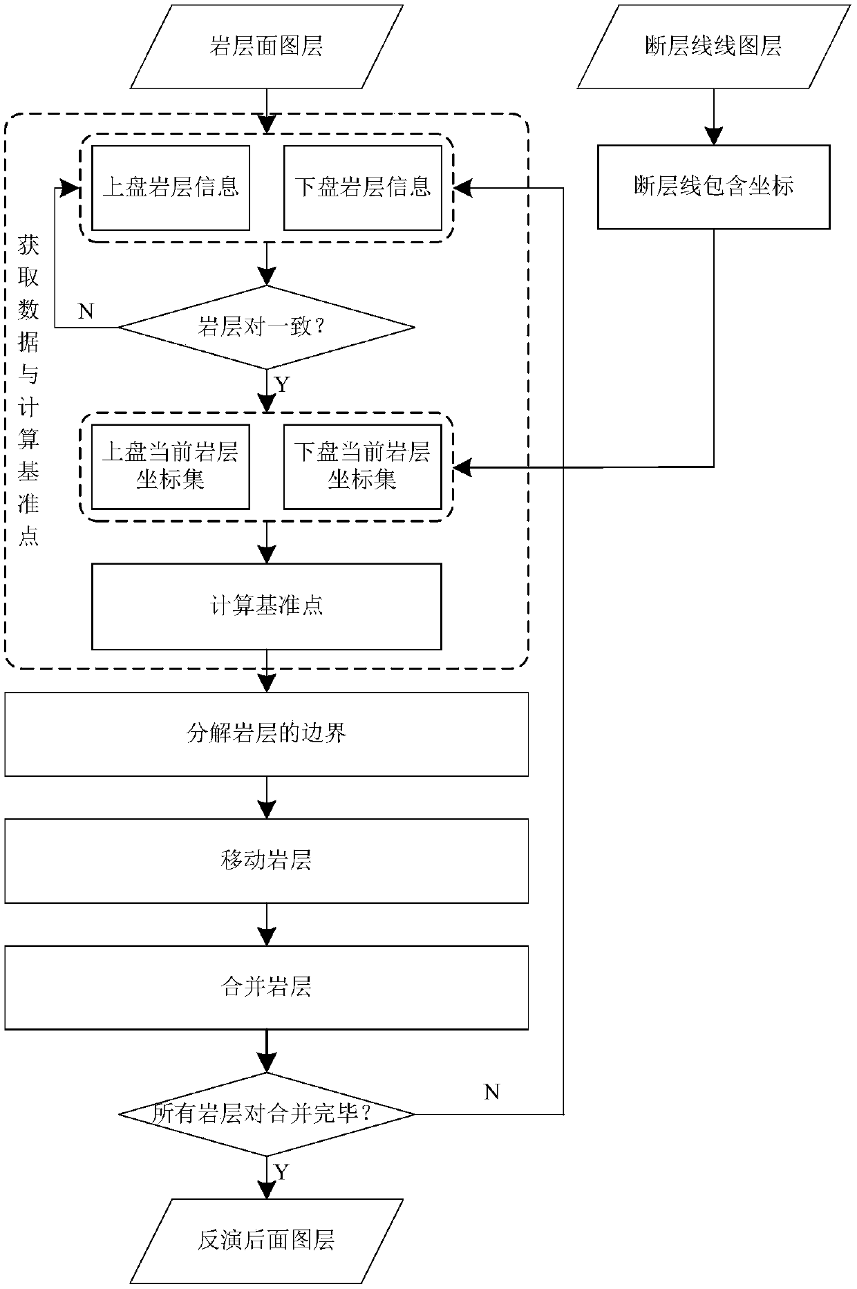
[0073] (1) Obtaining data and calculating benchmark points

[0074] Step 1.1: Load the rock layer and fault line layer data in vector format to obtain the set of rock layer elements in the hanging wall UpStra={us i |i=1,2,...,7} and the footwall contains rock bedding element set DownStra={ds i |i=1,2,…,7} and the point coordinate set FLine={(147692.772656289,145470.055976739),(147664.719420046,145498.197935516),…,(146785.737324302,1460204.849 points)(total)

[0075] Step...


PUM


Abstract

The invention discloses an automatic inversion method of single dip fault. The automatic inversion is performed on the single dip fault based on a geologic map. The method mainly comprises the following steps: 1) respectively computing the interaction of a stratum and a fault line, wherein each of the stratum and the fault line is corresponding to a hanging side and a heading side, thereby computing a datum point based on the interaction; 2) decomposing a stratum coordinate set corresponding to each of the hanging side and the heading side; 3) determining the datum point offset so as to move the decomposed coordinate set; and 4) combining the moved hanging side corresponding coordinate set and the moved heading side corresponding coordinate set. Through the adoption of the method disclosed by the invention, the automatic inversion of the single dip fault based on the geographic map is realized, the algorithm is clear, and the practicability is strong.

Description

technical field [0001] The invention belongs to the application field of geographic information technology, and in particular relates to an automatic inversion method of a single-dip fault based on a geological map. Background technique [0002] The inversion of geological structure refers to the process of inferring the original shape of the rock formation based on the type of structural geomorphology plus other conditions as constraints. As one of the most important structures in the earth's crust, faults are formed by the obvious displacement of rock layers or rock masses along the fracture surface, often forming rifts and cliffs. Inversion of the fault evolution process, simulating and restoring the original shape of the rock formation without faults, has certain research significance and application value for geological disaster prediction, geological resource development, and geological environmental protection. [0003] The application of fault inversion is mainly re...

Claims


Application Information

Patent Timeline
Patent Type & Authority Patents(China)
IPC IPC(8): G06F17/50
CPCG16Z99/00
Inventor 李安波李梦圆陈楹王凯亮
Owner NANJING NORMAL UNIVERSITY
Why Eureka
Try Eureka