Plan method for rapid coverage track search coordinated by multiple UAVs (Unmanned Aerial Vehicles)

A track planning and multi-UAV technology, applied in three-dimensional position/course control, non-electric variable control, instruments, etc.

Active Publication Date: 2017-02-15
BEIJING INSTITUTE OF TECHNOLOGYGY
View PDF4 Cites 72 Cited by
  • Summary
  • Abstract
  • Description
  • Claims
  • Application Information

AI Technical Summary

Problems solved by technology

[0005] At present, no scholars at home and abroad have studied the coverage search track planning method of the gray area with point, line and area key targets

Method used


Image

  • Plan method for rapid coverage track search coordinated by multiple UAVs (Unmanned Aerial Vehicles)
  • Plan method for rapid coverage track search coordinated by multiple UAVs (Unmanned Aerial Vehicles)
  • Plan method for rapid coverage track search coordinated by multiple UAVs (Unmanned Aerial Vehicles)

Examples


Embodiment 1

[0114] Four different scenarios are used to illustrate the feasibility and the effectiveness of the algorithm of a multi-UAV cooperative fast coverage search track planning method disclosed in this embodiment. The types and numbers of targets in Scenario 1 to Scenario 4 gradually increase, and the specific types and numbers are shown in Table 2.

[0115] Table 2 Description of the four scenarios

[0116]

[0117] Step 1, the covering search track of the point-line-plane special target.

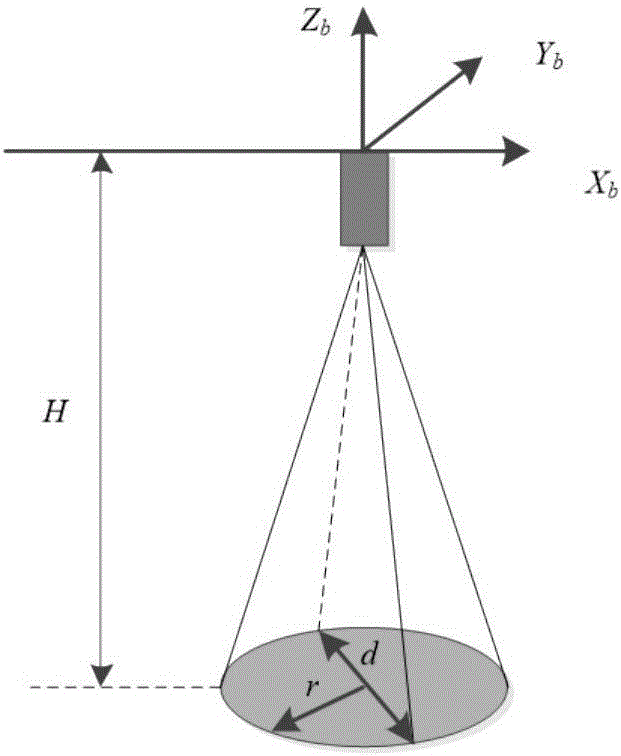
[0118] The ground field of view of the UAV seeker is affected by its flight altitude, attitude angle, and installation angle of the seeker. The UAV is regarded as a particle, and the ground field of view of the seeker is assumed to be circular and located at the front of the UAV. Below, the drone flies at a fixed altitude and its field of view on the ground is not affected by attitude angles and terrain undulations. Based on this, the UAV field of view model is established as figure 1 s...


PUM


Abstract

The invention discloses a plan method for rapid coverage track search coordinated by multiple UAVs, and belongs to the field of UAV track planning. Key searching objects, namely points, lines and surfaces, are extracted from a gray area according to prior information of a battlefield environment and geometric characteristics of an object existing area; the access sequence of the key searching objects is determined via an integer-dual-coded genetic algorithm; according to the key searching objects and the distribution sequence of the UAVs, a local shortest connection track from the end point of a present object coverage search track to the start point of a next object coverage search track is obtained via a Dubins path and a greedy strategy, the coverage search track of the next search object is obtained, and the UAV coordinated coverage search track is obtained. The coordinated rapid coverage search track of multiple UAVs in the special gray area can be planned, the coverage time is short, the robustness of the algorithm is high, and a regional full-coverage search track can be replaced effectively.

Description

technical field [0001] The present invention relates to a multi-UAV collaborative fast coverage search track planning method, in particular to a multi-UAV cooperative fast coverage search track planning method for special gray areas with point-line-surface targets, belonging to the UAV navigation area of ​​planning. Background technique [0002] UAV (Unmanned Aerial Vehicle, UAV) has become the best choice for boring, harsh and dangerous tasks due to its small size, strong mobility, low price, flexible take-off, no casualties, and simple air crew support. It is used in fields such as battlefield reconnaissance, ground attack, terrain surveying and mapping, and maritime search and rescue, and has played a major role. Since target search and intelligence reconnaissance in the combat area have become an important means of obtaining battlefield information, and the precise strike on the target in the informationized battlefield depends largely on the reconnaissance before the s...

Claims


Application Information

Patent Timeline
Patent Type & Authority Applications(China)
IPC IPC(8): G05D1/10
CPCG05D1/104
Inventor 刘莉龙腾温永禄王祝
Owner BEIJING INSTITUTE OF TECHNOLOGYGY
Why Eureka
Try Eureka