
POS data correction method suitable for weak gnss signal conditions

A POS data and signal technology, applied in the field of position and attitude measurement system data processing, can solve the problems of accuracy impact, GNSS signal occlusion, failure to provide positioning information, etc., and achieve the effect of improving accuracy

Active Publication Date: 2018-07-27
LEADOR SPATIAL INFORMATION TECH CORP
View PDF3 Cites 0 Cited by
  • Summary
  • Abstract
  • Description
  • Claims
  • Application Information

AI Technical Summary

Problems solved by technology

[0003] However, there are many high-rise buildings in the city, and the GNSS signal is severely blocked, so it cannot provide stable positioning information, and the integrated navigation solution cannot provide high-precision attitude, position, and speed. The accuracy of the information will also be affected.

Method used


Image

  • POS data correction method suitable for weak gnss signal conditions
  • POS data correction method suitable for weak gnss signal conditions

Examples


Embodiment Construction

[0029] The technical solution of the present invention will be specifically described below in conjunction with the accompanying drawings and embodiments.

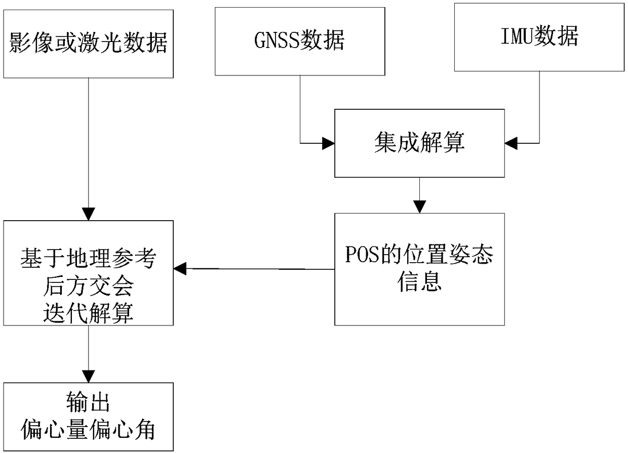
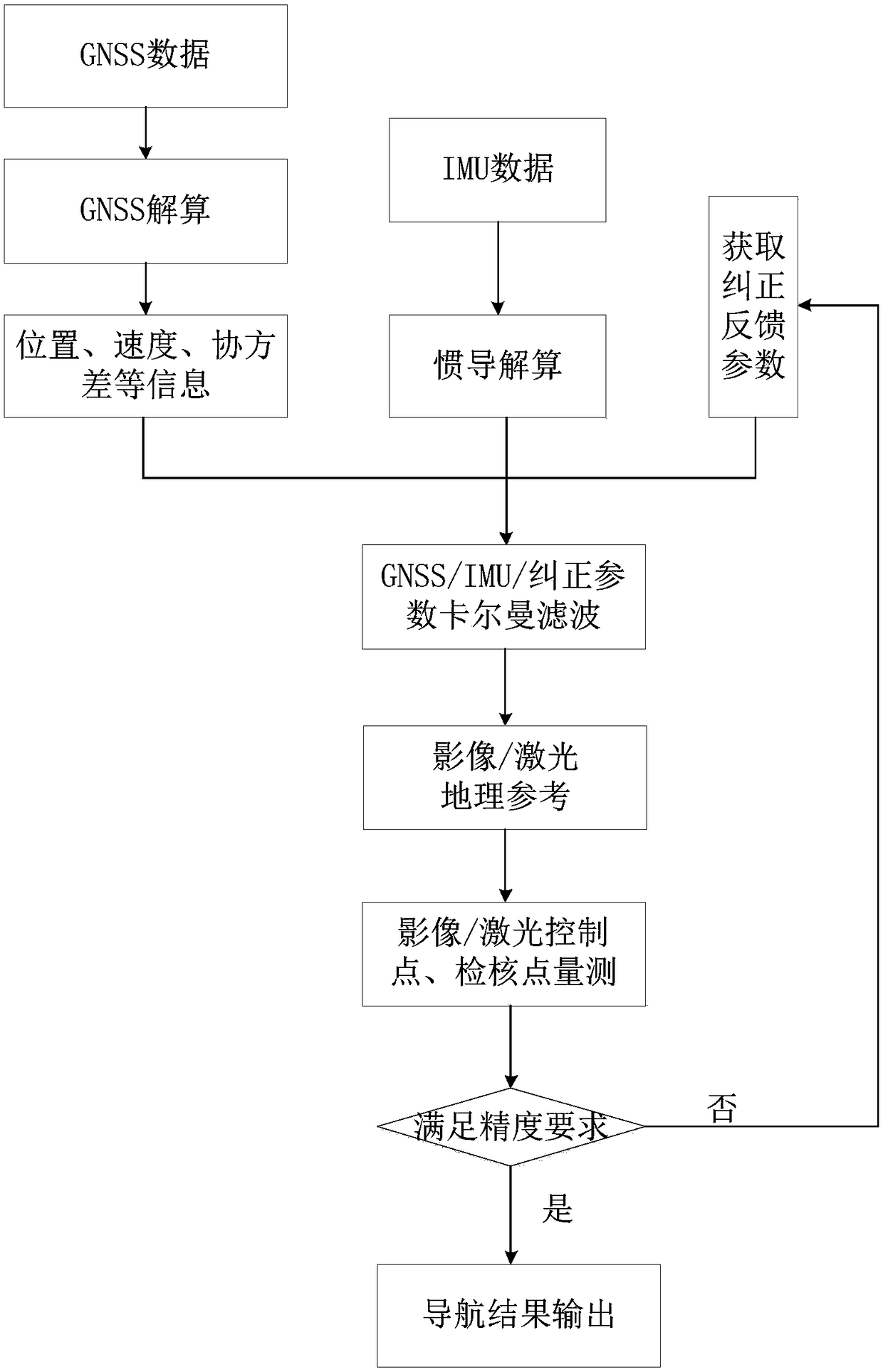
[0030] Under the condition of weak GNSS signal, the third-party (such as: CCD image, laser, etc.) measurement information is introduced to correct the error of the POS data processing result, thereby reducing the impact of the large long-term positioning error of GNSS on the accuracy of the integrated navigation result and achieving high precision Output of information such as attitude, position and velocity.

[0031] The main components of the POS system are GNSS receiver and IMU equipment. Among them, the GNSS receiver receives the positioning data, and the IMU provides the instantaneous speed, acceleration and direction information of the device, and then realizes data fusion by using Kalman filter technology. The POS system gives full play to the respective advantages of GNSS and INS, and can be used to obtain the spa...


PUM


Abstract

The invention provides a POS data rectification method suitable for a weak GNSS signal condition. Third party measurement information is introduced, the error correction of a POS data processing result is carried out, and a process of obtaining external correction information and a process of applying the external correction information are included. The third party measurement information is an image or laser data. The process of obtaining the external correction information comprises the output of the eccentricity and eccentricity angle of the image or laser data relative to a POS system. In the process of applying the external correction information, the image or laser data is used to output POS result information which is in accordance with a precision requirement. The method is suitable for the weak GNSS signal condition, a GNSS positioning result is not reliable for a long time, the precision of a POS navigation solution result is poor, through introducing third party rectification correction information, the precision of the POS navigation solution result is improved and the requirement of a engineering application is satisfied, and a problem of POS high precision positioning under the weak GNSS signal is solved.

Description

technical field [0001] The invention belongs to the technical field of Position and Orientation System (Position and Orientation System, POS) data processing technology, and in particular relates to a POS data deviation correction method suitable for weak GNSS signal conditions. Background technique [0002] POS integrates GNSS (Global Navigation Satellite System, global satellite navigation system) technology and inertial navigation (Inertial Navigation System) technology, and combines the long-term high-precision performance characteristics of GNSS technology with the short-term high-precision integrated navigation positioning of inertial navigation technology The system can well make up for the defects of the two technologies and form a complementary performance. [0003] However, there are many high-rise buildings in the city, and GNSS signals are severely blocked, which cannot provide positioning information with stable accuracy. The accuracy of integrated navigation so...

Claims


Application Information

Patent Timeline
Patent Type & Authority Patents(China)
IPC IPC(8): G01S19/40
CPCG01S19/40
Inventor 郭晟曹圣群康晓光邵慧超洪勇严悦
Owner LEADOR SPATIAL INFORMATION TECH CORP
Learn More