Transmission tower identifying and positioning method based on high-resolution remote sensing image

A technology of transmission towers and remote sensing images, which is applied in the field of image processing and can solve problems such as the failure of power towers in super-large image target detection algorithms

Pending Publication Date: 2021-06-25
LIAONING TECHNICAL UNIVERSITY
View PDF7 Cites 0 Cited by
  • Summary
  • Abstract
  • Description
  • Claims
  • Application Information

AI Technical Summary

Problems solved by technology

Finally, the method of this paper solves the problem of YOLOv3’s failure of the super-large image target detection algorithm and the high-precision positioning of the electric tower, providing support for the intelligence of the power industry

Method used


Image

  • Transmission tower identifying and positioning method based on high-resolution remote sensing image
  • Transmission tower identifying and positioning method based on high-resolution remote sensing image
  • Transmission tower identifying and positioning method based on high-resolution remote sensing image

Examples


Embodiment Construction

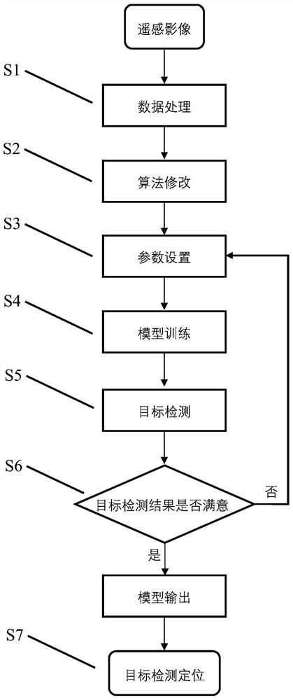
[0031] according to figure 1 The steps shown are a detailed description of a method for identifying and locating transmission towers based on high-resolution remote sensing images of the present invention.

[0032] Step 1: Data processing includes collecting high-resolution remote sensing images as raw data, performing operations such as data labeling and data augmentation, and the detailed operations are as follows:

[0033] (1) The original image includes panchromatic image and multi-spectral image, using ENVI software to correct and fuse the original data to obtain a high-resolution image;

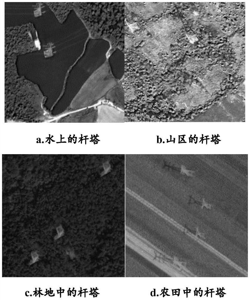
[0034] (2) Use the Python program to crop the obtained high-resolution remote sensing image to the size required for network training (416*416) such as figure 2 A sample of the different regions shown;

[0035] (3) Convert the cropped tif image into jpg format, use LableImg software to mark the data set according to the VOC data format, and randomly divide the data set into training...


PUM


Abstract

The invention discloses a transmission tower identification and positioning method based on a high-resolution remote sensing image. The detection of a large-range transmission tower can be realized based on the high-resolution remote sensing image. On the basis, an improved YOLOv3 target rapid detection algorithm is applied to transmission tower detection and positioning of a high-resolution remote sensing image, aiming at different shapes of the transmission tower in the remote sensing image, the size of a prior frame is reset through K-means, a CIoU loss function is introduced in frame regression, DIoU and NMS are combined, and the problem of missing detection of dense small targets by YOLOv3 is solved. In order to solve the problems that the number of layers of feature extraction deepens details of a target and position information is reduced, an SPP module is added to enrich the expression ability of a final feature map. In addition, the method solves the problem that YOLOv3 fails to detect a super-large image target, achieves the automatic recognition and positioning of the transmission tower, and provides a guarantee for the safe operation of a power grid.

Description

technical field [0001] The invention belongs to the technical field of image processing, in particular to a method for identifying and locating transmission towers based on high-resolution remote sensing images. Background technique [0002] With the rapid development of strong smart grid and energy Internet, my country has formed a power grid system with UHV transmission channels as the backbone. However, the UHV power grid has a long transmission distance, a large coverage area, and complex environmental conditions. It is vulnerable to various natural and man-made disasters such as strong winds, freezing, lightning strikes, floods, and external failures. Severe tower structural failures such as tower tilt, tower material loss, and main material bending. High-voltage transmission towers are one of the most important infrastructures in electrical facilities. Their operating status determines the stability and safety of the entire power grid, and the detection of transmissio...

Claims


Application Information

Patent Timeline
Patent Type & Authority Applications(China)
IPC IPC(8): G06K9/00G06K9/34G06K9/62G06N3/04
CPCG06V20/176G06V10/267G06N3/045G06F18/253G06F18/214
Inventor 宋成根张正鹏卜丽静
Owner LIAONING TECHNICAL UNIVERSITY
Why Eureka
Try Eureka