Urban spatial big data-based urban redevelopment and land recognition method and system

A land identification and redevelopment technology, applied in the field of geographic information systems, can solve the problem of being unable to objectively and accurately judge whether urban land needs to be redeveloped

Inactive Publication Date: 2017-10-24
深圳市数字城市工程研究中心
View PDF3 Cites 11 Cited by
  • Summary
  • Abstract
  • Description
  • Claims
  • Application Information

AI Technical Summary

Problems solved by technology

[0005] The purpose of the present invention is to provide a method and system for urban redevelopment land identification based on urban spatial big data, aiming to solve the problem in the prior art that it is impossible to objectively and accurately judge whether urban land needs to be redeveloped

Method used


Image

  • Urban spatial big data-based urban redevelopment and land recognition method and system
  • Urban spatial big data-based urban redevelopment and land recognition method and system
  • Urban spatial big data-based urban redevelopment and land recognition method and system

Examples


Embodiment Construction

[0021] In order to make the technical problems, technical solutions and beneficial effects to be solved by the present invention clearer, the present invention will be further described in detail below in conjunction with the accompanying drawings and embodiments. It should be understood that the specific embodiments described here are only used to explain the present invention, not to limit the present invention.

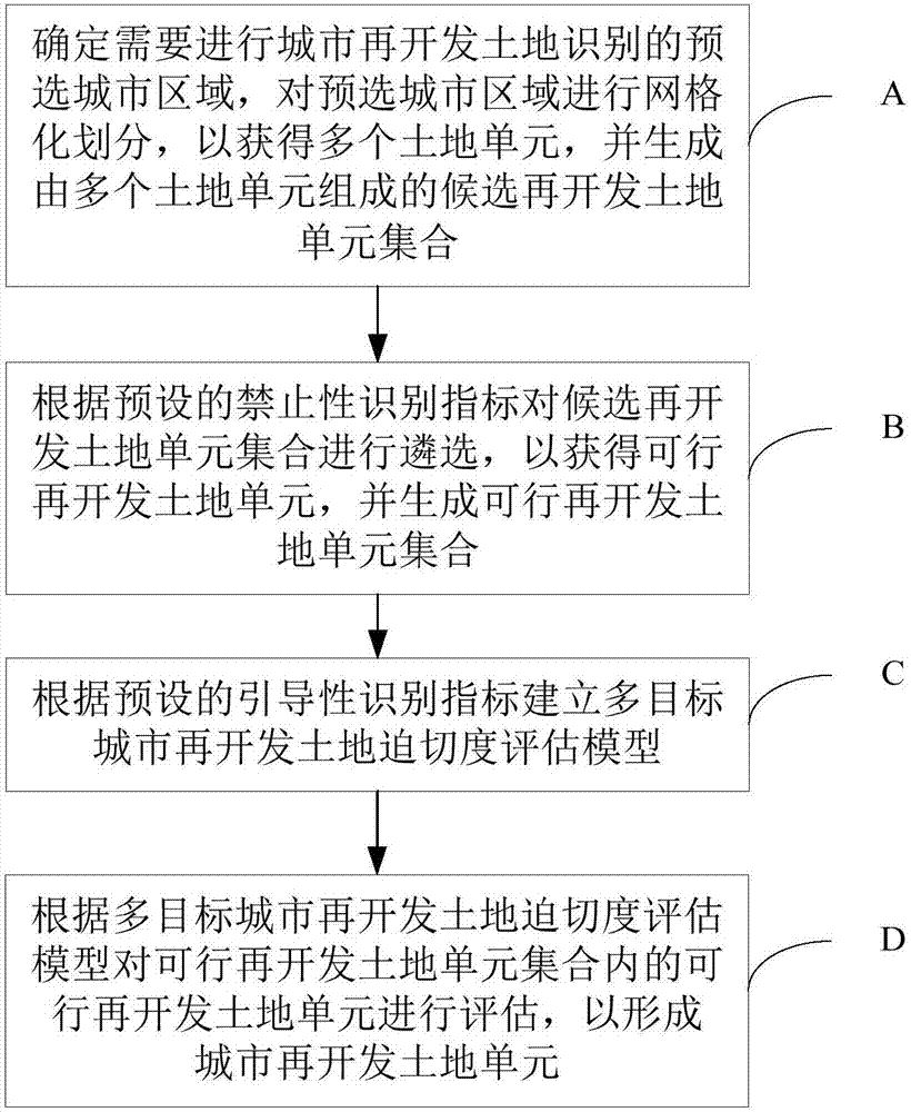
[0022] An embodiment of the present invention provides an urban redevelopment land identification method based on urban spatial big data. figure 1 It is a flow chart of urban redevelopment land identification based on urban spatial big data provided by an embodiment of the present invention. like figure 1 As shown, the method includes steps A to D.

[0023] Step A: Determine the pre-selected urban areas that need to be identified for urban redevelopment land, perform grid division on the pre-selected urban areas to obtain multiple land units, and generate a set o...


PUM


Abstract

The invention provides an urban spatial big data-based urban redevelopment and land recognition method and a system. The method comprises the steps of A, determining a preselected city region to be subjected to urban redevelopment and land recognition, subjecting the preselected city region to grid division so as to obtain a plurality of land units, and generating a candidate re-development land unit assembly formed by the plurality of land units; B, according to preset prohibitive identification indexes, selecting the candidate re-development land unit assembly to obtain feasible redevelopment land units, and generating a feasible redevelopment land unit assembly; C, according to preset introductory identification indexes, establishing a multi-target urban redevelopment land urgent degree evaluation model; D, according to the multi-target urban redevelopment land urgent degree evaluation model, evaluating feasible redevelopment land units in the feasible redevelopment land unit assembly to form urban redevelopment land units. According to the invention, the micro-scale objective identification for the land is provided.

Description

technical field [0001] The invention relates to the field of geographic information systems, in particular to a method and system for identifying land for urban redevelopment based on urban spatial big data. Background technique [0002] When a city develops to a certain stage, there will be decline phenomena such as "material obsolescence, functional degradation, and low efficiency". At this time, the city needs to be redeveloped. At this time, it is necessary to determine whether the land in a specific area needs to be redeveloped. [0003] However, since there is no objective and accurate urban redevelopment identification technology at present, the determination method of urban redevelopment land is blind. The existing technology can only make relatively subjective redevelopment identification on the scale of urban streets and above. This identification method is not enough precise. [0004] There is currently no ideal solution in the industry for the problem of being u...

Claims


Application Information

Patent Timeline
Patent Type & Authority Applications(China)
IPC IPC(8): G06Q10/06G06Q50/26
Inventor 沈少青郑清菁孙语晴姜仁荣罗平杜茎深赵杏杏张芳芳
Owner 深圳市数字城市工程研究中心
Why Eureka
Try Eureka