
System and method for azimuth calibration of scanning point cloud in underground space

A technology for underground space and orientation calibration, applied in the field of information processing, can solve the problem of point cloud orientation deviation, etc., and achieve the effect of solving deviation

Active Publication Date: 2020-08-28
BEIJING MAGGRP TECH
View PDF18 Cites 0 Cited by
  • Summary
  • Abstract
  • Description
  • Claims
  • Application Information

AI Technical Summary

Problems solved by technology

[0003] The invention provides a point cloud orientation calibration system and method for underground space scanning, which is used to solve the problem that the point cloud orientation is prone to deviation in the prior art

Method used


Image

  • System and method for azimuth calibration of scanning point cloud in underground space

Examples


Embodiment Construction

[0030] The specific implementation manners of the present invention will be further described in detail below in conjunction with the accompanying drawings and embodiments. The following examples are used to illustrate the present invention, but are not intended to limit the scope of the present invention.

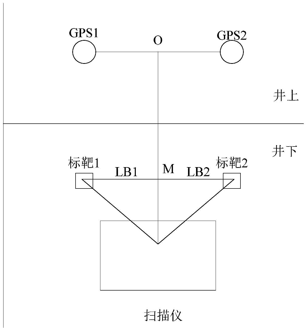
[0031] figure 1 It shows that an embodiment of the present invention provides a point cloud orientation calibration system for underground space scanning, including a scanner installed in the underground space and two targets (target 1 and target 2), and a space located on the ground The two antennas (GPS1 and GPS2) and the positioning device, as well as the calibration device, where the two targets and the two antennas are located on the same vertical plane and the connection line between the two targets is parallel to that between the two antennas connection;

[0032] The scanner is used to scan the underground space to obtain a point cloud set, wherein the point cloud...


PUM


Abstract

The invention provides a point cloud azimuth calibration system and method for underground space scanning. The point cloud azimuth calibration system comprises a scanner and two targets disposed in anunderground space, two antennas and positioning devices disposed in an aboveground space, and a calibration device, wherein the two targets and the two antennas are in a same vertical plane and a connecting line between the two targets is parallel to the connecting line between the two antennas; the calibration device is used to acquire a set of point clouds sent by the scanner, antenna coordinates sent by the positioning devices, a vertical height between preset antennas and the targets, and a length between the two preset targets, obtain antenna azimuthal angles according to the antenna coordinates, and obtain calibration coordinates of the targets according to the antenna coordinates, the vertical height between the antennas and the targets, and the antenna azimuthal angles; and the calibration device is further used to perform point cloud azimuth calibration according to point coordinates and the calibration coordinates of the targets, and solves the problem of high possibility ofdeviation of the point cloud azimuth calibration at present.

Description

technical field [0001] The invention relates to the technical field of information processing, in particular to a point cloud azimuth calibration system for underground space scanning. Background technique [0002] When using a 3D laser scanner to scan a small underground space, it is necessary to process the absolute orientation of the point cloud accurately. Since the magnetic field in the underground space is disturbed by some factors, if the electronic compass cannot be used, it will not only be unable to accurately orient the point cloud scanned by a single station, but may cause a large direction deviation. Contents of the invention [0003] The invention provides a point cloud orientation calibration system and method for underground space scanning, which is used to solve the problem that the point cloud orientation is prone to deviation in the prior art. [0004] In the first aspect, an embodiment of the present invention provides a point cloud azimuth calibration...

Claims


Application Information

Patent Timeline
Patent Type & Authority Patents(China)
IPC IPC(8): G01C25/00G01S19/42
CPCG01C25/00G01S19/42
Inventor 王旭阳詹登峰马怡昌李毅柴贝
Owner BEIJING MAGGRP TECH
Features
  • Generate Ideas
  • Intellectual Property
  • Life Sciences
  • Materials
  • Tech Scout
  • Unparalleled Data Quality
  • Higher Quality Content
  • 60% Fewer Hallucinations
Learn More