Method of determining datum elevation of river bottom based on large-section measurement data and system thereof

A technology for measuring data and large sections, which is used in electrical digital data processing, special data processing applications, water conservancy projects, etc. Effect

Active Publication Date: 2018-10-02
NARI TECH CO LTD +1
View PDF6 Cites 6 Cited by
  • Summary
  • Abstract
  • Description
  • Claims
  • Application Information

AI Technical Summary

Problems solved by technology

[0022] In order to solve the deficiencies in the prior art, the present invention provides a method and system for determining the river bottom reference elevation based on large-section measurement data, which solves the problem of uncertainty caused by relying on manual experience to confirm the river bottom reference elevation

Method used


Image

  • Method of determining datum elevation of river bottom based on large-section measurement data and system thereof
  • Method of determining datum elevation of river bottom based on large-section measurement data and system thereof
  • Method of determining datum elevation of river bottom based on large-section measurement data and system thereof

Examples


Embodiment Construction

[0073] The present invention will be further described below in conjunction with the accompanying drawings. The following examples are only used to illustrate the technical solution of the present invention more clearly, but not to limit the protection scope of the present invention.

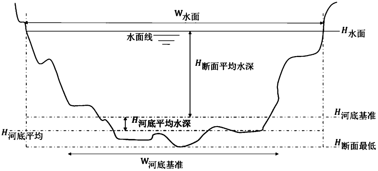
[0074] A method of determining the river bottom reference elevation based on large-section survey data of the present invention comprises the following steps:

[0075] 1) Combined with the database to establish a unified large-section data model, the large-section data model includes a large-section measurement definition model, a large-section information model, and a large-section measurement process data model, and jointly build large-section measurement data for regions, watersheds, rivers or reservoirs storage system;

[0076] 2) Import large-section data measurement results according to the data model structure. Large-section data measurement results can have multiple data formats and dat...


PUM


Abstract

The invention discloses a method of determining a datum elevation of a river bottom based on large-section measurement data and a system thereof. The method comprises the following steps that a uniform large-section data model is established by combining a database; a large-section data measurement result standard format and a data structure specification are formulated; whether a large-section data measurement result meets a requirement and a specification is verified; and the river bottom datum elevation is calculated according to the large-section data meeting the requirement; and the riverbottom average elevation, a river bottom width, a river bottom area, a river bottom average elevation change rate and a river bottom area change rate are calculated on the basis of the river bottom datum elevation datum elevation. According to the method, the river bottom datum elevation is automatically calculated and identified based on the inflection point recognition algorithm by utilizing the large-section measurement data of a river channel, so that the inconsistency and randomness brought by manual operation are reduced; the average elevation of the river bottom is, and the accuracy ofcalculating the characteristic values such as the river bottom average elevation, the average river bottom width and the like are guaranteed, and the influence of a river bottom flushing change is faded caused by a non-river bottom characteristic value obtained by participating in calculating a non-river bottom part riverbed elevation section is eliminated.

Description

technical field [0001] The invention relates to the technical field of sediment data processing, in particular to a method and system for determining a river bottom reference elevation based on large-section measurement data. Background technique [0002] The determination of the river bottom reference elevation of a section is of great significance for analyzing the erosion and deposition changes of a reservoir section over time. The average river bottom elevation of each section can be directly calculated according to the large-section measurement data and the river bottom reference elevation of the section. It has two meanings: on the one hand, the time change of the average river bottom elevation directly reflects the erosion and deposition changes of the section; Above this elevation, the change of sediment erosion and silting in the reservoir area is not obvious, and the shape of the cross-section is basically stable, but below this elevation, affected by the movement ...

Claims


Application Information

Patent Timeline
Patent Type & Authority Applications(China)
IPC IPC(8): E02B1/00G06F17/50
CPCE02B1/00G06F30/20
Inventor 陈建姚峰王建平王峰吴善锋葛瑜
Owner NARI TECH CO LTD
Why Eureka
Try Eureka