A Scene Classification Method for Aerial Remote Sensing Images Based on Image Complexity Judgment

An image complexity, aerial remote sensing technology, applied in the field of aerial remote sensing image scene classification, can solve the problems of large content differences, inaccurate processing of complex images, and time redundancy of simple image classification.

Active Publication Date: 2019-11-12
BEIHANG UNIV
View PDF5 Cites 0 Cited by
  • Summary
  • Abstract
  • Description
  • Claims
  • Application Information

AI Technical Summary

Problems solved by technology

[0008] The present invention is aimed at different aerial remote sensing images, the content of which is quite different, and a single method may generate large time redundancy when classifying simple images, and may not be accurate enough when processing complex images

Method used


Image

  • A Scene Classification Method for Aerial Remote Sensing Images Based on Image Complexity Judgment
  • A Scene Classification Method for Aerial Remote Sensing Images Based on Image Complexity Judgment
  • A Scene Classification Method for Aerial Remote Sensing Images Based on Image Complexity Judgment

Examples


Embodiment

[0151] In this example, an aerial remote sensing image data set containing 302 images is tested. The test process and results are as follows:

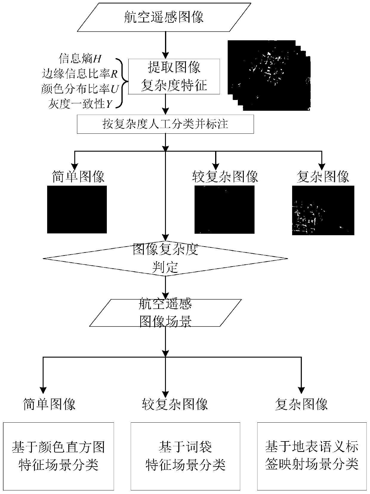
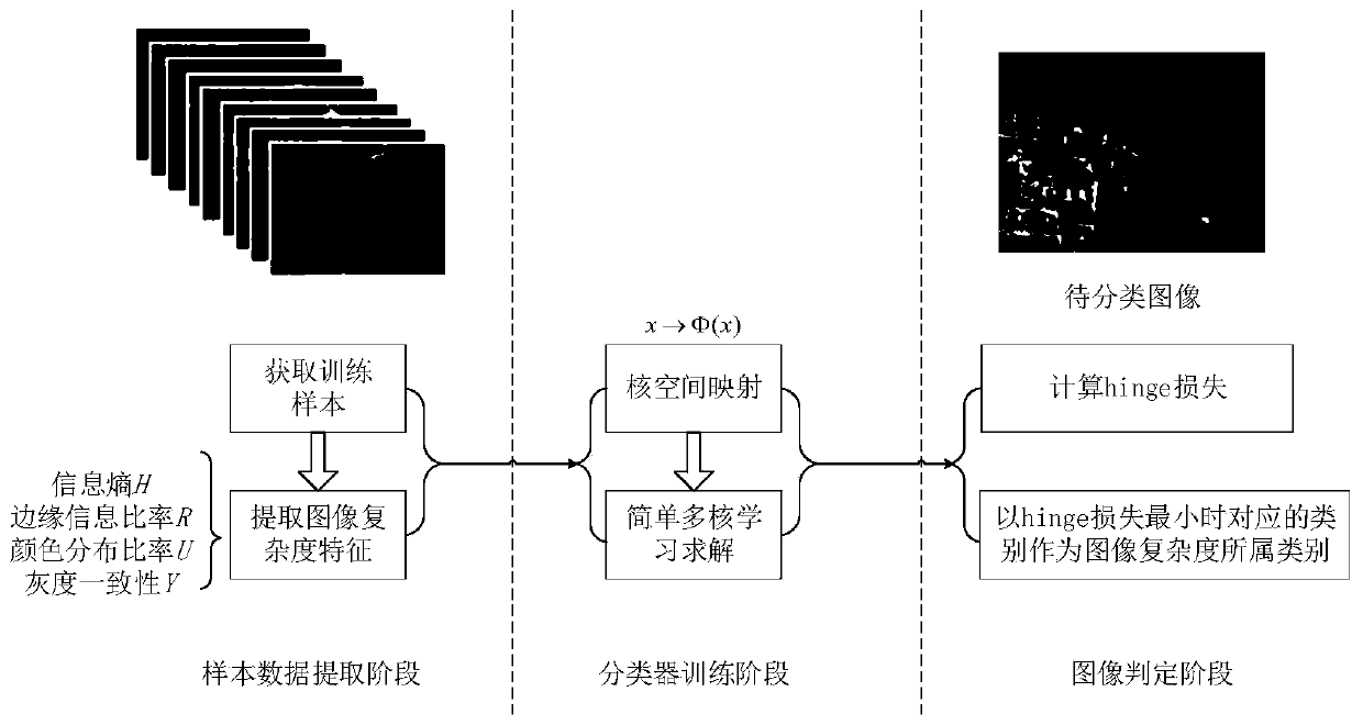
[0152] The first step is to perform complexity feature extraction on the aerial remote sensing image to be processed.

[0153] 1) Build an aerial remote sensing image data set

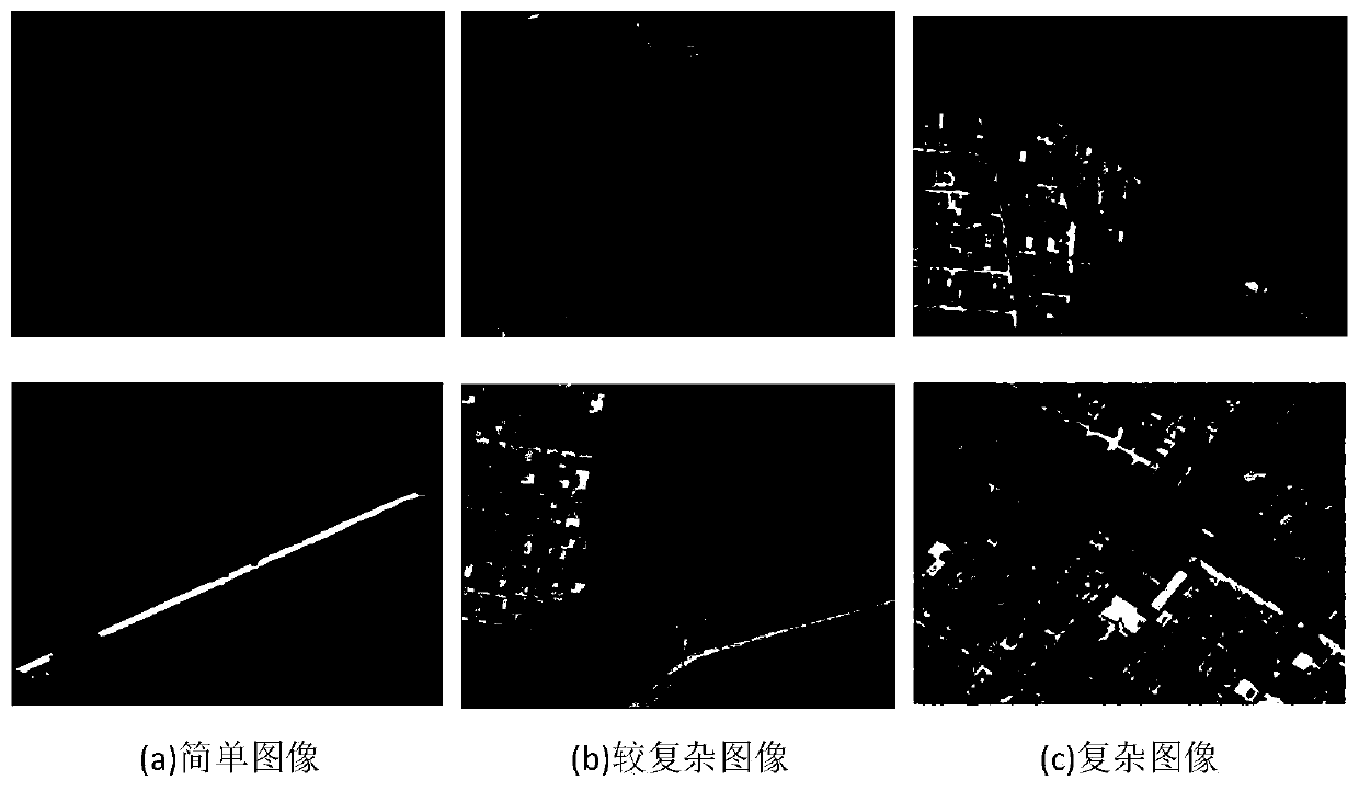
[0154] The aerial remote sensing image data set includes 302 real aerial remote sensing images with 1392*1040 pixels. The images are divided into simple images, more complex images and complex images according to the complexity level, and they are manually labeled. Among them, as shown in Table 1, there are 100 complex images, 93 more complex images, and 109 simple images; 20 representative images of various complexity images are selected as the training set, and the remaining images are used as the test set.

[0155] Table 1

[0156]

[0157] 2) Extract the four types of complexity features of the image

[0158] Extract the four types of complexity features of all aeria...


PUM


Abstract

The invention discloses an aerial remote sensing image scene classification method based on image complexity judgment, which belongs to the technical field of image processing, extracts the complexity features of aerial remote sensing images, and selects a number of aerial remote sensing images to be processed to form training samples; the remaining aerial remote sensing The images form a set of test samples. The training sample set is manually classified and marked according to the complexity, and combined with the classifier after multi-core mapping, three image complexity classifiers are obtained. The complexity features of the aerial remote sensing image A in the test set are respectively extracted and input into three classifiers, and the category corresponding to the minimum hinge loss is taken as the category of the complexity of the image, and the judgment result of the complexity of the aerial remote sensing image A is obtained. According to the judging result of the complexity of the aerial remote sensing image A, use an appropriate method to classify the scene of the aerial remote sensing image A. The invention can effectively judge the complexity of the aerial remote sensing image, and efficiently and accurately realize the scene classification of the aerial remote sensing image.

Description

Technical field [0001] The invention belongs to the technical field of image processing, and specifically relates to a method for classifying aerial remote sensing image scenes based on image complexity judgment. Background technique [0002] In recent years, with the continuous progress of domestic aviation, electronics and information industries, drone-related technologies have also developed rapidly, which has promoted a variety of aerial remote sensing images, improved quality, and more extensive applications. Aerial remote sensing imagery is the main method for obtaining basic geographic information, the basis for surveying and mapping work, and the main data source for relevant departments to obtain the original surface information. It is related to land and resources management, disaster prevention and relief, transportation and water conservancy construction, urban planning, national defense construction, Environmental protection and scientific research are closely relate...

Claims


Application Information

Patent Timeline
Patent Type & Authority Patents(China)
IPC IPC(8): G06K9/00G06K9/46G06K9/62
CPCG06V20/13G06V10/50G06V10/513G06V10/56G06F18/2411G06F18/214
Inventor 刘春辉丁文锐陈映雪李红光
Owner BEIHANG UNIV
Why Eureka
Try Eureka