Single image non-stereoscopic observation topographic map mapping method based on tilt photography

An oblique photography and non-stereoscopic technology, which is applied in the field of geographic surveying and mapping, can solve the problem that the elevation accuracy is difficult to meet the requirements of large-scale map production specifications, and achieve the effect of reducing hardware configuration, ensuring accuracy and convenient operation.

Pending Publication Date: 2019-06-14
NORTHWEST UNIV
View PDF4 Cites 2 Cited by
  • Summary
  • Abstract
  • Description
  • Claims
  • Application Information

AI Technical Summary

Problems solved by technology

[0003] Surveying methods used in the prior art such as figure 1 As shown, this method has always had two insurmountable problems in production practice: the first problem is that the operator must perform stereoscopic observation, and the stereoscopic observation ability oft

Method used


Image

  • Single image non-stereoscopic observation topographic map mapping method based on tilt photography
  • Single image non-stereoscopic observation topographic map mapping method based on tilt photography
  • Single image non-stereoscopic observation topographic map mapping method based on tilt photography

Examples


Embodiment Construction

[0020] The following will clearly and completely describe the technical solutions in the embodiments of the present invention with reference to the accompanying drawings in the embodiments of the present invention. Obviously, the described embodiments are only some, not all, embodiments of the present invention. Based on the embodiments of the present invention, all other embodiments obtained by persons of ordinary skill in the art without making creative efforts belong to the protection scope of the present invention.

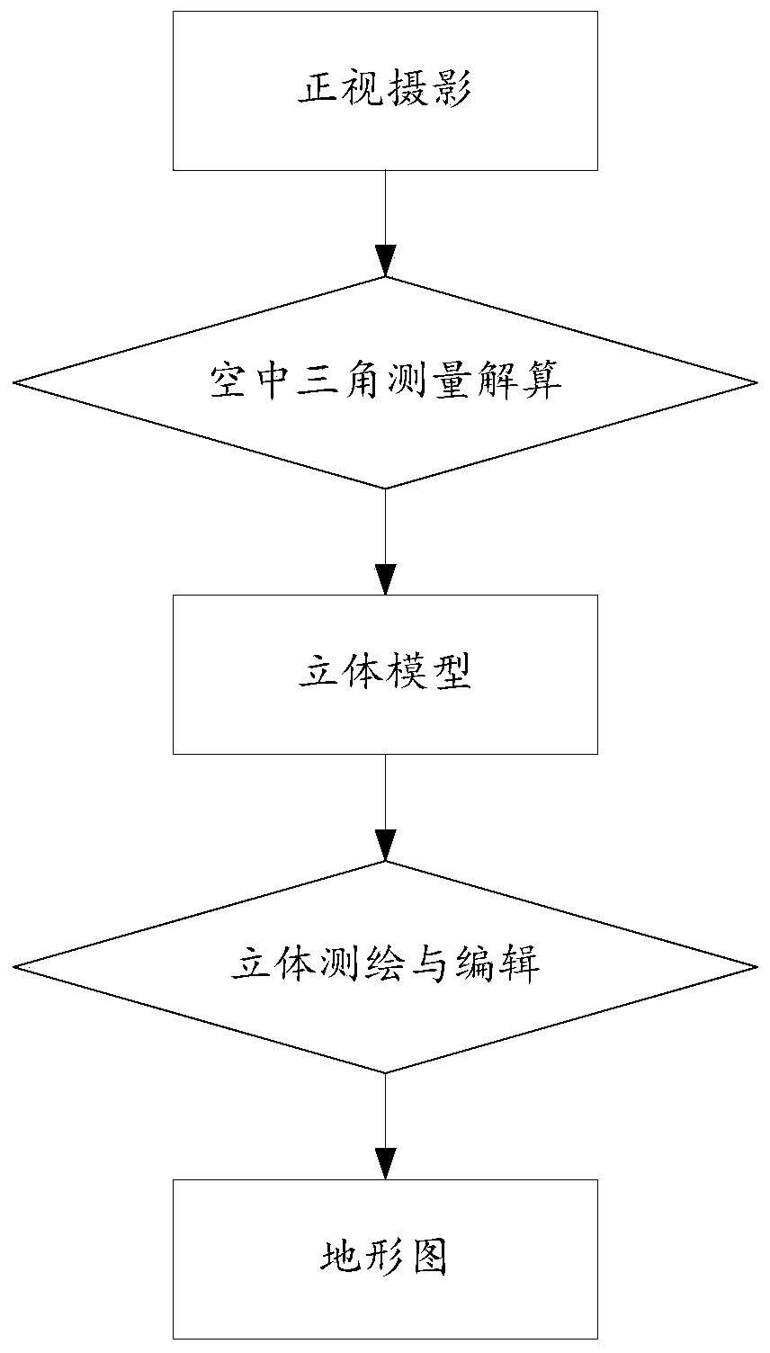
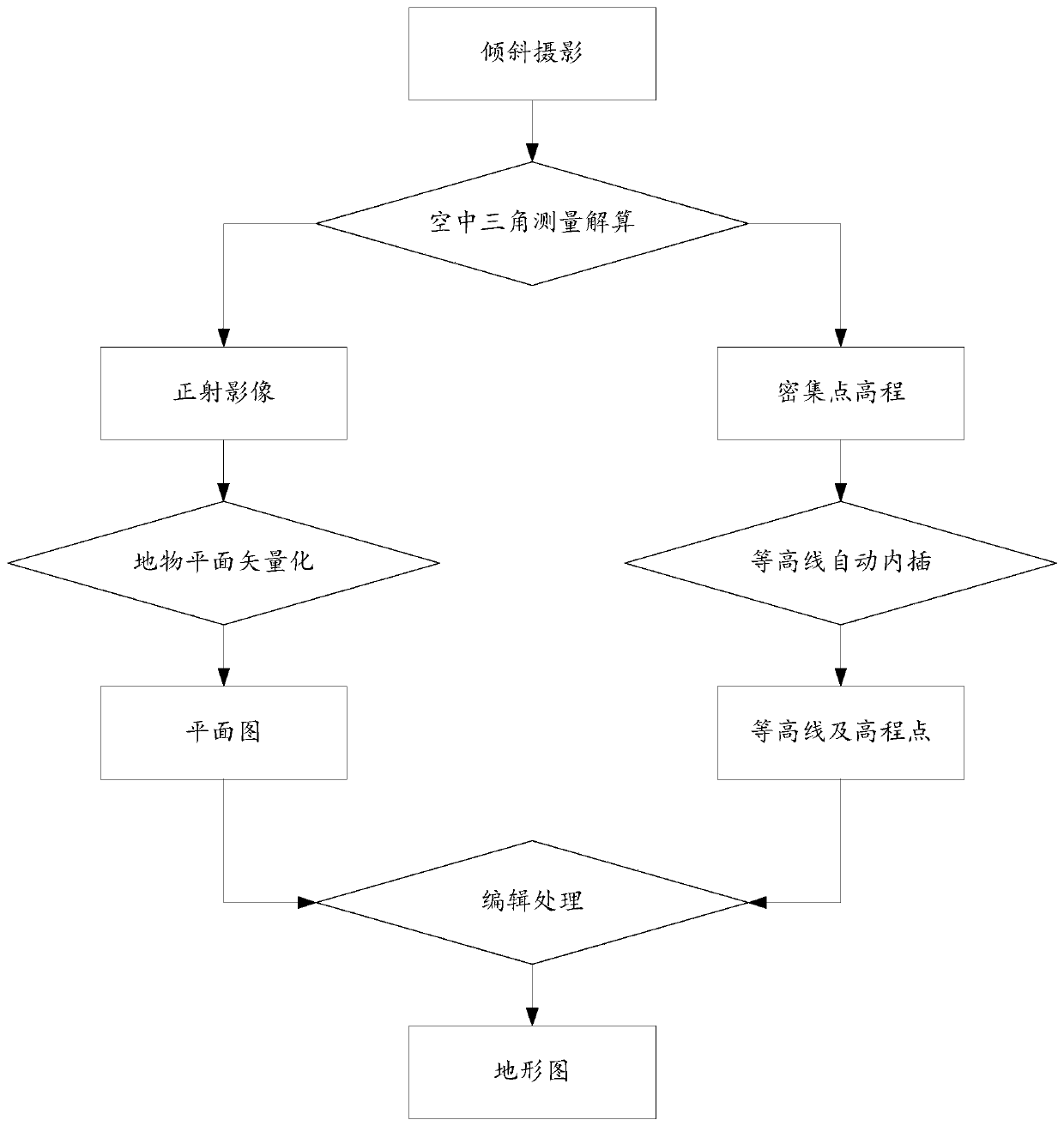
[0021] refer to figure 2 , the present invention provides a single-image non-stereoscopic topographic map surveying and mapping method based on oblique photography, the method comprising the following steps:

[0022] Utilize the photographic platform to take multi-angle oblique photographic pictures, and the photographic platform can be various forms of platforms such as unmanned aerial vehicle, manned aircraft or satellite, and the described photographic pla...


PUM


Abstract

The invention discloses a single image non-stereoscopic observation topographic map mapping method based on tilt photography, and relates to the technical field of geographic mapping. The method comprises the following steps of obtaining a tilt photography picture; performing aerial triangulation calculation on the tilt photography picture to obtain an orthoimage and point cloud data; performing aplanar plane vectorization process on the orthoimage to obtain a plan graph, automatically interpolating the contour line of the point cloud data to obtain contour lines and elevation points; editingthe plan graph, contour lines and elevation points to get a topographic map. The method combines tilt photography and aerial triangulation technology to establish a non-stereoscopic observation topographic map mapping method for plane and elevation separated operations, so that new operators can perform topographic map production without stereoscopic observation training, thereby changing the topographic map mapping method of stereoscopic observation or multi-image observation of traditional photography measurement, and meeting the accuracy requirements of topographic map mapping.

Description

technical field [0001] The invention relates to the technical field of geographic surveying and mapping, in particular to a method for surveying and mapping a single-image non-stereoscopic topographic map based on oblique photography. Background technique [0002] The topographic map surveying method of traditional photogrammetric stereo observation adopts operational processes such as aerial triangulation, stereo image pair establishment, and stereo mapping. This topographic map production mode is quite mature in algorithm, and has been used in the world for 50 to 60 years. , is still the mainstream way of producing topographic maps of various surveying and mapping units. [0003] Surveying methods used in the prior art such as figure 1 As shown, this method has always had two insurmountable problems in production practice: the first problem is that the operator must perform stereoscopic observation, and the stereoscopic observation ability often needs eight weeks of train...

Claims


Application Information

Patent Timeline
IPC IPC(8): G01C11/00
CPCG01C11/34G01C5/00
Inventor 谢元礼
Owner NORTHWEST UNIV
Why Eureka
Try Eureka