Jolt platform unmanned aerial vehicle-mounted SAR real-time imaging processing method

A technology of real-time imaging and processing methods, applied in radio wave measurement systems, radio wave reflection/re-radiation, utilization of re-radiation, etc. effect, fine focus effect, computationally efficient effect

Active Publication Date: 2020-05-22
XIDIAN UNIV
View PDF4 Cites 3 Cited by
  • Summary
  • Abstract
  • Description
  • Claims
  • Application Information

AI Technical Summary

Problems solved by technology

Most of the existing SAR real-time processors adopt the method of stacking chips, which causes a large amount of performance redundancy while satisfying the real-time performance of imaging, which is very unfavorable for cost control and power consumption reduction.

Method used


Image

  • Jolt platform unmanned aerial vehicle-mounted SAR real-time imaging processing method
  • Jolt platform unmanned aerial vehicle-mounted SAR real-time imaging processing method
  • Jolt platform unmanned aerial vehicle-mounted SAR real-time imaging processing method

Examples


Embodiment Construction

[0037] Embodiments of the present invention will be described in detail below in conjunction with examples, but those skilled in the art will understand that following examples are only used to illustrate the present invention, and should not be considered as limiting the scope of the present invention.

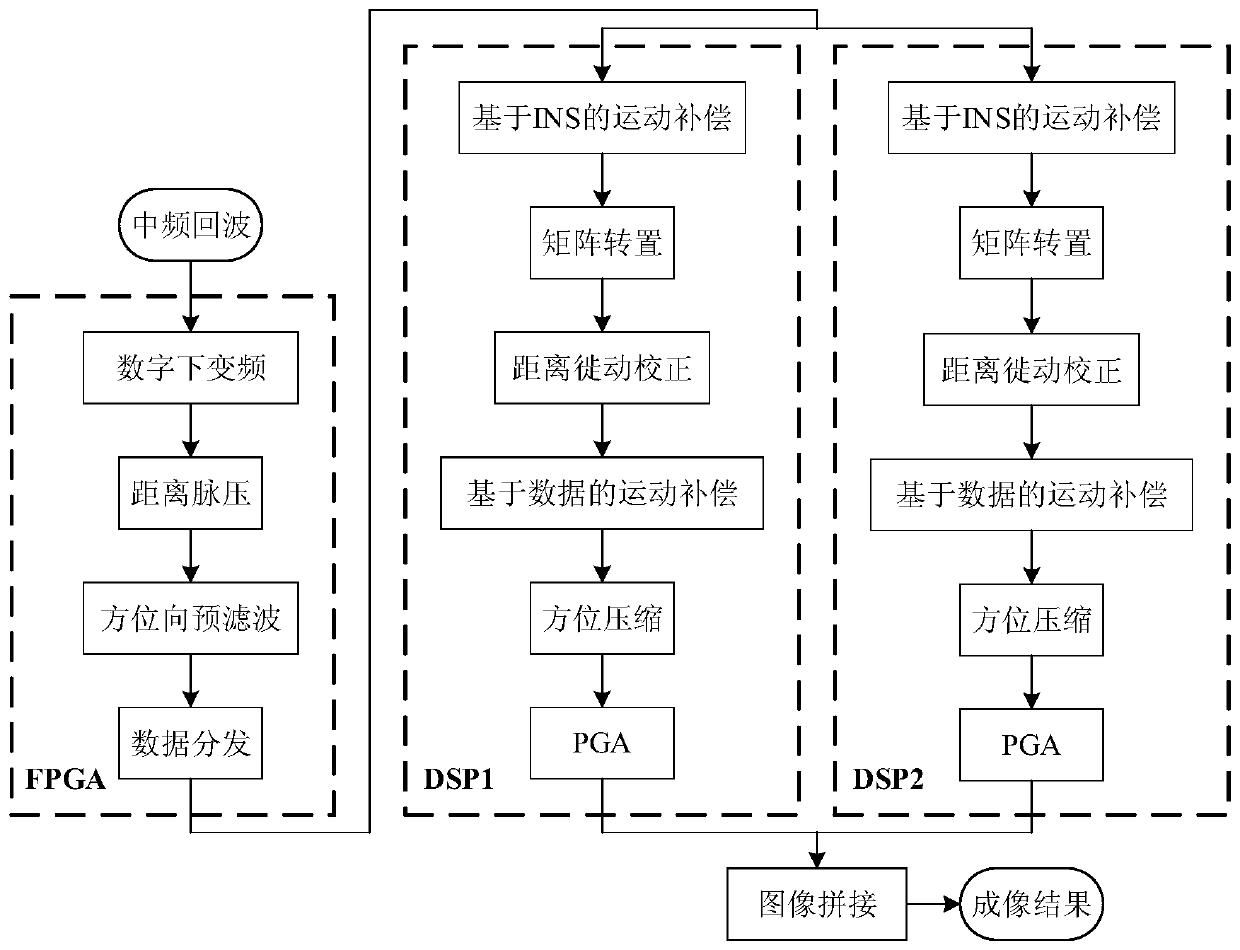
[0038] The invention provides a real-time imaging processing method of unmanned aerial vehicle SAR on a bumpy platform, and its specific processing flow chart is as follows figure 1 shown. The FPGA side performs digital down-conversion, range pulse pressure, azimuth pre-filtering and data distribution, and then DSP1 and DSP2 perform INS-based motion compensation, matrix transposition, range migration correction, data-based motion compensation, azimuth compression and PGA, Finally, the image mosaic is completed on the DSP1 side and sent to the system board through the PCIe interface. The present invention will be further specifically described below in conjunction with the ac...


PUM


Abstract

The invention belongs to the field of unmanned aerial vehicle remote sensing surveying. The invention discloses a jolt platform unmanned aerial vehicle-mounted SAR real-time imaging processing method.According to the unmanned aerial vehicle-mounted SAR real-time imaging processing based on a heterogeneous multi-core chip, digital down-conversion, distance pulse pressure and azimuth pre-filteringprocessing taking multiply-accumulate operation as a main body is executed by utilizing the advantage of high calculation efficiency of an FPGA, and the FPGA performs data distribution and task allocation according to DSP resources; the advantage of high programming flexibility of the DSP is utilized, jolt platform SAR imaging processing based on multi-level motion compensation is executed, the DSP end carries out motion compensation processing based on inertial navigation information, carries out motion compensation processing based on data, carries out image domain self-focusing processing and other motion error compensation technologies, high-resolution imaging of the jolt platform represented by the unmanned aerial vehicle is achieved, the hardware resource utilization rate is greatlyimproved, the focusing effect of SAR real-time imaging processing of the jolt platform is good, and the robustness is high.

Description

technical field [0001] The invention relates to the field of UAV remote sensing surveying and mapping, in particular to a UAV-borne SAR real-time imaging processing method on a bumpy platform. Background technique [0002] Synthetic aperture radar (SAR) can obtain two-dimensional high-resolution images of ground scenes, and has broad application prospects in the fields of remote sensing detection and terrain mapping. At the same time, the UAV platform has unique advantages such as low cost and small size. The advantages of the two can be organically combined by carrying SAR on the UAV platform, making UAV-borne SAR a research focus in recent years. [0003] The weight of the UAV platform is relatively light, and its flight path is easily affected by weather factors such as cross wind and air flow, thus introducing large motion errors, which is a typical bumpy platform. Most of the existing solutions combine the inertial navigation system (INS) for motion compensation proces...

Claims


Application Information

Patent Timeline
IPC IPC(8): G01S13/90
CPCG01S13/9011G01S13/9019
Inventor 梁毅张罡范家赫陈文平赵衍一
Owner XIDIAN UNIV
Why Eureka
Try Eureka