
A method and system for UAV induction based on location spoofing

A UAV, current location technology, applied in the field of satellite navigation, can solve problems such as unrealization and UAV navigation deception, and achieve the effect of fast induction speed and good induction effect.

Active Publication Date: 2022-07-29
BEIHANG UNIV
View PDF6 Cites 0 Cited by
  • Summary
  • Abstract
  • Description
  • Claims
  • Application Information

AI Technical Summary

Problems solved by technology

[0006] In view of the above-mentioned analysis, the present invention aims to provide a method and system for guiding UAVs based on location deception to solve the problem that existing methods cannot achieve fast, efficient and concealed navigation deception of target UAVs

Method used


Image

  • A method and system for UAV induction based on location spoofing
  • A method and system for UAV induction based on location spoofing
  • A method and system for UAV induction based on location spoofing

Examples


Embodiment 1

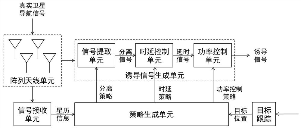
[0072] A specific embodiment of the present invention discloses a position spoofing-based UAV induction system. The schematic diagram is as follows: figure 1 As shown, the system includes: a satellite navigation signal real-time receiving unit, a target tracking unit, a strategy generating unit, and an inducing signal generating unit; wherein,

[0073] The satellite navigation signal real-time receiving unit is used to receive and analyze the real satellite navigation signals of all visible satellites, and obtain the ephemeris information of all visible satellites; exemplarily, in this process, a high-performance satellite navigation receiver can be used to receive all the satellite navigation signals in real time. The real navigation signal of the satellite can be seen, and the acquisition, tracking, ephemeris reception, positioning calculation and navigation information storage / output of the real satellite navigation signal are completed. Exemplarily, the satellite navigatio...

Embodiment 2

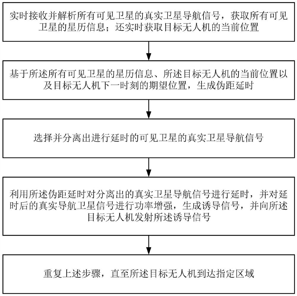
[0122] In Embodiment 2 of the present invention, a method for inducing drones based on location spoofing is also provided. The flowchart is as follows: figure 2 As shown, the method includes the following steps:

[0123] Step S1: Receive and analyze the real satellite navigation signals of all visible satellites in real time, and obtain the ephemeris information of all visible satellites; also obtain the current position of the target UAV in real time;

[0124] Step S2: generate a pseudo-range delay based on the ephemeris information of all visible satellites, the current position of the target drone and the expected position of the target drone at the next moment;

[0125] Step S3: selecting and separating the real satellite navigation signals of the visible satellites that are delayed;

[0126] Step S4: delaying the separated real satellite navigation signal by using the pseudorange delay, and enhancing the power of the delayed real navigation satellite signal to generate ...


PUM


Abstract

The invention relates to a method and system for inducing unmanned aerial vehicles based on position deception, and relates to the field of satellite navigation, which solves the problem that the prior art cannot realize fast, efficient and concealed navigation and deception of unmanned aerial vehicles. The system includes: an array antenna unit for receiving real satellite navigation signals of all visible satellites; a signal receiving unit for acquiring ephemeris information according to the received real satellite navigation signals of all visible satellites; a target tracking unit for real-time acquisition of unmanned aerial vehicles The current position of the aircraft; the strategy generation unit, based on the ephemeris information, the current position of the UAV and the expected position at the next moment, outputs the pseudo-range delay, the delayed real satellite navigation signal, and the transmission power; the induction signal generation unit, Separate the delayed real satellite navigation signal and other real satellite navigation signals; perform delay and power enhancement on the separated real satellite navigation signal according to the pseudo-range delay and transmit power in turn, generate an induction signal, and transmit it to the UAV.

Description

technical field [0001] The invention relates to the technical field of satellite navigation, in particular to a method and system for inducing an unmanned aerial vehicle based on position spoofing. Background technique [0002] With the gradual opening of the country to low-altitude flying, a large number of easy-to-control remote-control helicopters, multi-rotor aircraft and other unmanned aerial vehicles have become more and more widely used. Due to the small size, low price and simple control of drones, if they are used by criminals, it will bring great challenges to social stability and security work. At present, there have been many incidents of drones entering sensitive airspace illegally. How to effectively counteract drones has become a hot and difficult issue in research at home and abroad. [0003] At present, the technical means of countering UAVs at home and abroad show a diversified development trend, which can be mainly divided into two categories: physical sh...

Claims


Application Information

Patent Timeline
Patent Type & Authority Patents(China)
IPC IPC(8): G01S19/21
CPCG01S19/21
Inventor 史鹏亮薛瑞
Owner BEIHANG UNIV
Learn More