
Index database establishment and retrieval method based on massive geographical location information

A technology of geographic location information and establishment methods, which is applied in the field of index database establishment and retrieval based on massive geographic location information, can solve problems such as high memory usage, increased delay, and slow efficiency of retrieval methods, and achieve the effect of improving matching retrieval speed

Pending Publication Date: 2021-12-07
WUHAN INSTITUTE OF TECHNOLOGY
View PDF0 Cites 0 Cited by
  • Summary
  • Abstract
  • Description
  • Claims
  • Application Information

AI Technical Summary

Problems solved by technology

This is not advisable as it can lead to high memory usage and increase latency, for example if both models need to be run with dedicated and limited hardware such as a GPU
Also, in many cases, similar types of calculations are performed on both, leading to redundant processing and unnecessary complexity
[0004] In addition, in the location recognition of street view images, the number of images is mostly, and the efficiency of conventional retrieval methods is too slow, which makes it impossible to achieve practical application effects in street view images

Method used


Image

  • Index database establishment and retrieval method based on massive geographical location information
  • Index database establishment and retrieval method based on massive geographical location information
  • Index database establishment and retrieval method based on massive geographical location information

Examples


Embodiment Construction

[0029] In order to make the objectives, technical solutions and advantages of the present invention clearer, the present invention will be further described in detail below with reference to the accompanying drawings and embodiments. It should be understood that the specific embodiments described herein are only used to explain the present invention, but not to limit the present invention.

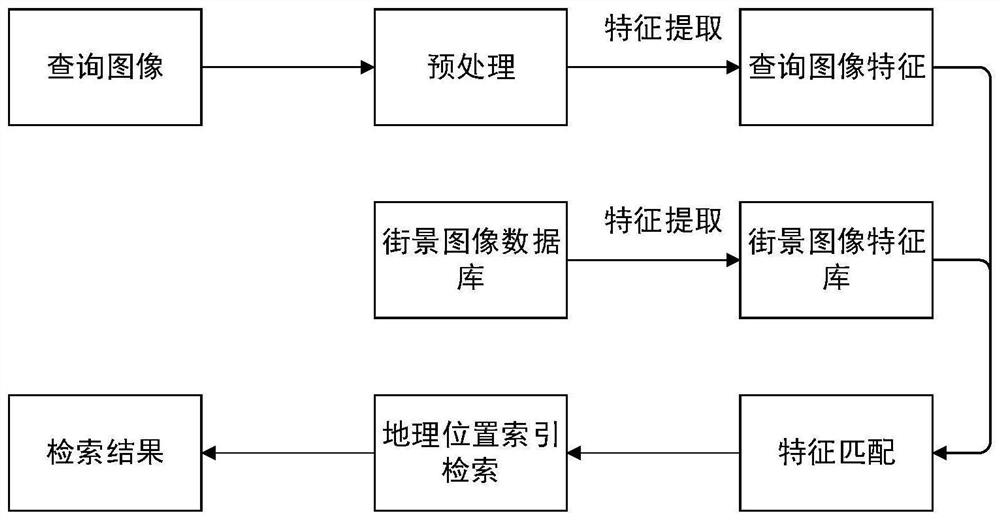
[0030] like figure 1 As shown in the figure, the index building method based on the massive geographic location information of the present invention mainly extracts the features of the images from all the images in the street view image library using the same method, and then inserts the extracted feature data into the index library, and the insertion is completed. After that, the index library can be used in the query process. The retrieval method searches according to the data structure of the index database, obtains r retrieval results, and then performs recommendation calculation on t...


PUM


Abstract

The invention discloses an index establishment and retrieval method based on massive geographical location information, which mainly comprises the following steps of: extracting the features of all images in a streetscape image library by using the same method, inserting the extracted feature data into an index library, and using the index library in a query process after the insertion is completed; carrying out retrieval out according to the data structure of the index database to obtain r retrieval results, and then carrying out recommendation calculation on the retrieval results, so that the retrieval results are reordered according to the geographic position information, and the retrieval results are more in line with the expectation of the user.

Description

technical field [0001] The invention relates to the field of image processing, in particular to a method for establishing and retrieving an index database based on massive geographic location information. Background technique [0002] Content-based image retrieval task (CBIR) is a long-standing research topic in the field of computer vision. In today's field of image retrieval, the main focus is on instance-level image retrieval tasks. In this task, given an object / scene / building type image to be queried, the query contains pictures taken from different angles, lighting or occlusions, and containing the same object / scene / building. [0003] To obtain high image retrieval performance, two image representation methods are required: global features and local features. Today, most systems that rely on both features require separate models to extract each feature. This is not desirable as it can lead to high memory usage and increased latency, for example if both models need to...

Claims


Application Information

Patent Timeline
Patent Type & Authority Applications(China)
IPC IPC(8): G06F16/51G06F16/535G06F16/538G06F16/587G06F16/29
CPCG06F16/51G06F16/535G06F16/538G06F16/587G06F16/29
Inventor 李晓林徐港周一凡黄磊邵长成
Owner WUHAN INSTITUTE OF TECHNOLOGY
Learn More