Compensation for mounting misalignment of a navigation device

a technology of positioning device and compensation, which is applied in the direction of navigation, instruments, surveying and navigation, etc., can solve the problems of limited satellite signal availability, satellite signals can be completely blocked or greatly attenuated inside buildings, and other limitations of gps and other satellite based navigational systems

Active Publication Date: 2009-10-08
CSR TECH HLDG
View PDF35 Cites 95 Cited by
  • Summary
  • Abstract
  • Description
  • Claims
  • Application Information

AI Technical Summary

Benefits of technology

[0010]Compensating for the misalignment of a navigation device with respect to a vehicle is described. In one example, the compensation is made by applying a high pass filter to a measured acceleration of the vehicle to produce a motion a...

Problems solved by technology

GPS and other satellite based navigational systems have some limitations such as the availability of a sufficient number of satellite signals.
In addition to this, the satellite signals can be completely blocked or greatly attenuated inside buildings.
In addition, tunnels...

Method used


Image

  • Compensation for mounting misalignment of a navigation device
  • Compensation for mounting misalignment of a navigation device
  • Compensation for mounting misalignment of a navigation device

Examples


Embodiment Construction

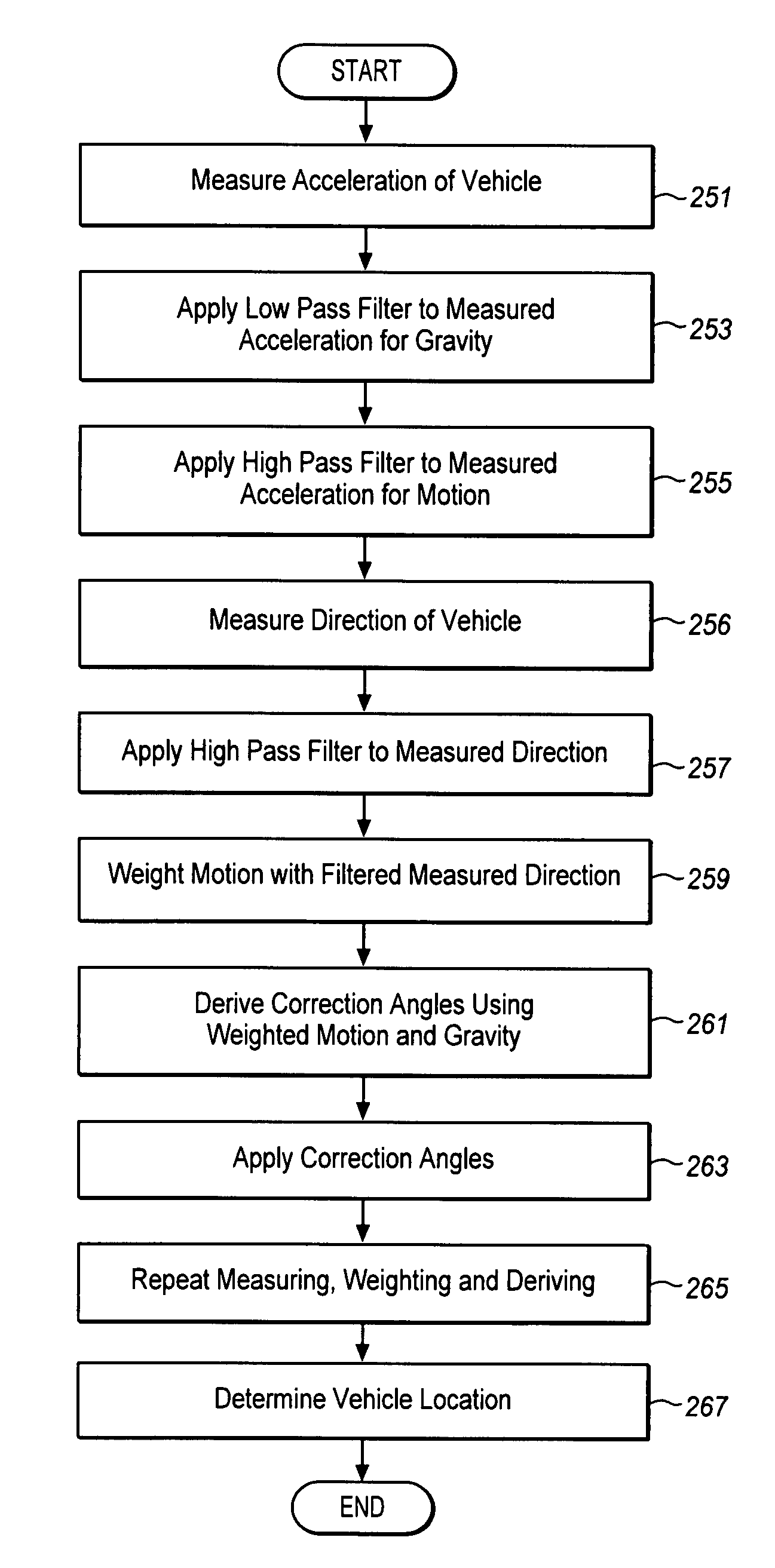
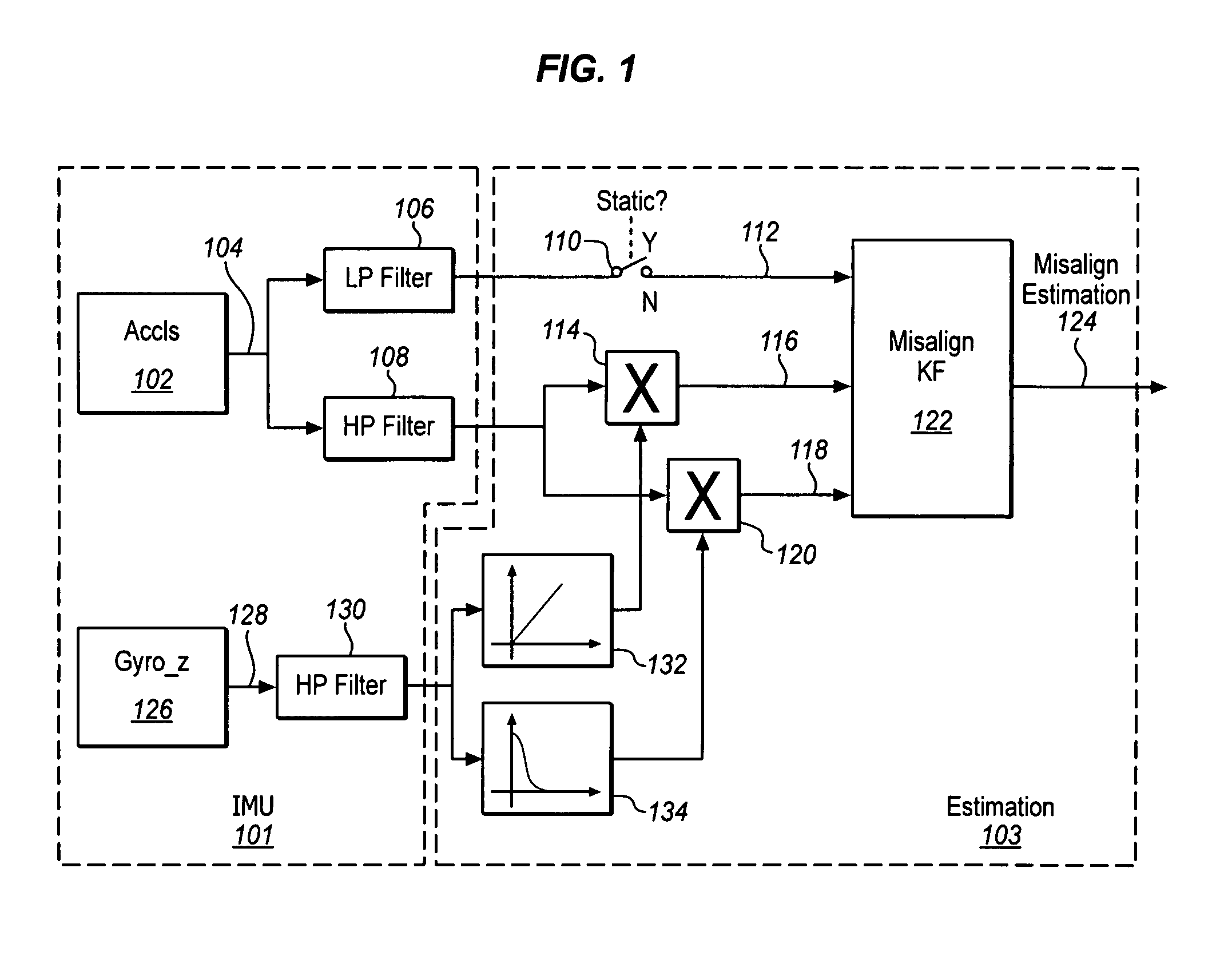
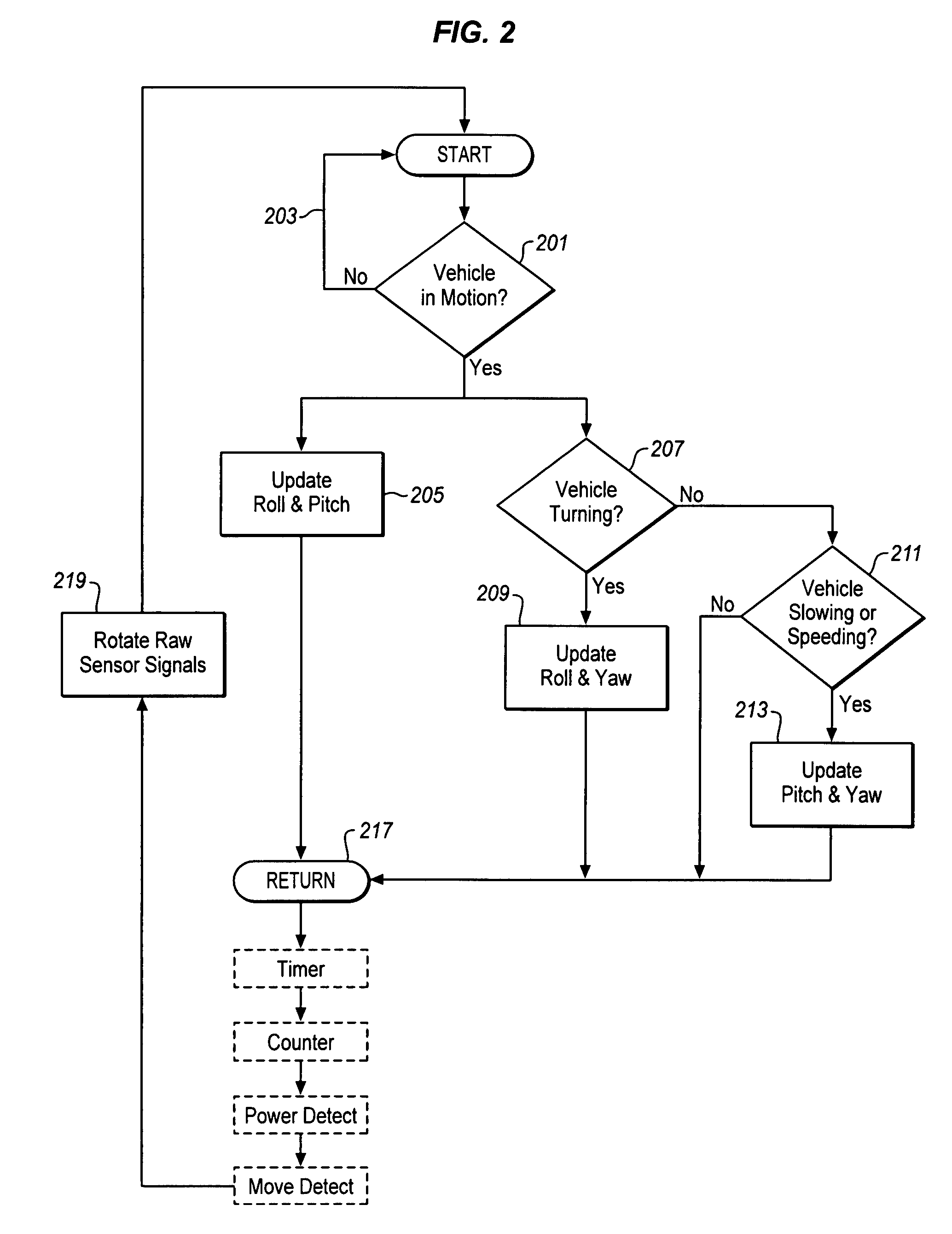
[0017]Any misalignment between the inertial sensors used by a navigation device and a vehicle carrying the inertial sensors, such as a car or a truck, can affect the navigation device's accuracy. This misalignment can be estimated and the estimates used to compensate for the misalignment. This is particularly useful for portable navigation devices since a portable navigation device is normally installed without strictly aligning the device in the vehicle. The misalignment is therefore likely to be different each time the navigation device is removed and returned again to the vehicle.

[0018]The typical inertial sensors used for vehicle navigation are accelerometers and gyroscopes. These may be part of a separate removable portable navigation device, or they may be mounted to the vehicle. In some cases, the sensors may also be used for other systems, such as stability control, anti-lock braking, traction control, airbag control and other control systems. The vehicle's motion and raw in...


PUM


Abstract

Compensating for the misalignment of a navigation device with respect to a vehicle is described. In one example, the compensation is made by applying a high pass filter to a measured acceleration of the vehicle to produce a motion acceleration signal, weighting the motion acceleration signal with a measured steering rate of the vehicle, and deriving misalignment parameters for the navigation device with respect to the vehicle using the weighted motion acceleration signal.

Description

BACKGROUND[0001]1. Field[0002]The present description pertains to the field of determining the location of a vehicle using a portable navigation device and, in particular, to correcting location determinations to compensate for the possible misalignment of the portable location device in a vehicle.[0003]2. Related Art[0004]With the development of radio and space technologies, several satellite based navigation systems have already been built and more will be in use in the near future. One example of such satellite based navigation systems is the Global Positioning System (GPS), which is built and operated by the United States Department of Defense. The system uses twenty-four or more satellites orbiting the earth at an altitude of about 11,000 miles with a period of about twelve hours. These satellites are placed in six different orbits such that at any one time as many as six satellites are visible at any one location on the surface of the earth (except near the Earth's poles). Eac...

Claims


Application Information

Patent Timeline
IPC IPC(8): G01C21/16G01C21/00
CPCG01C21/16G01C21/28G01C21/265G01C21/185
Inventor HAN, SHAOWEINIU, XIAOJIMA, CHANGLIN
Owner CSR TECH HLDG
Why Eureka
Try Eureka