Simplified Creation of Customized Maps

a map and map technology, applied in the field of generating and customizing maps, can solve the problem of time-consuming and time-consuming task of quick creation of customized content for maps, and achieve the effect of efficient and timely production

Active Publication Date: 2012-05-17
GOOGLE LLC
View PDF29 Cites 8 Cited by
  • Summary
  • Abstract
  • Description
  • Claims
  • Application Information

AI Technical Summary

Benefits of technology

[0006]Therefore, what are needed are systems and methods that allow for efficient and timely production of customized maps showing selective information.

Problems solved by technology

While GIS systems can store vast amounts of data, quickly creating customized content for a map is a time consuming task.

Method used


Image

  • Simplified Creation of Customized Maps
  • Simplified Creation of Customized Maps
  • Simplified Creation of Customized Maps

Examples


example system embodiments

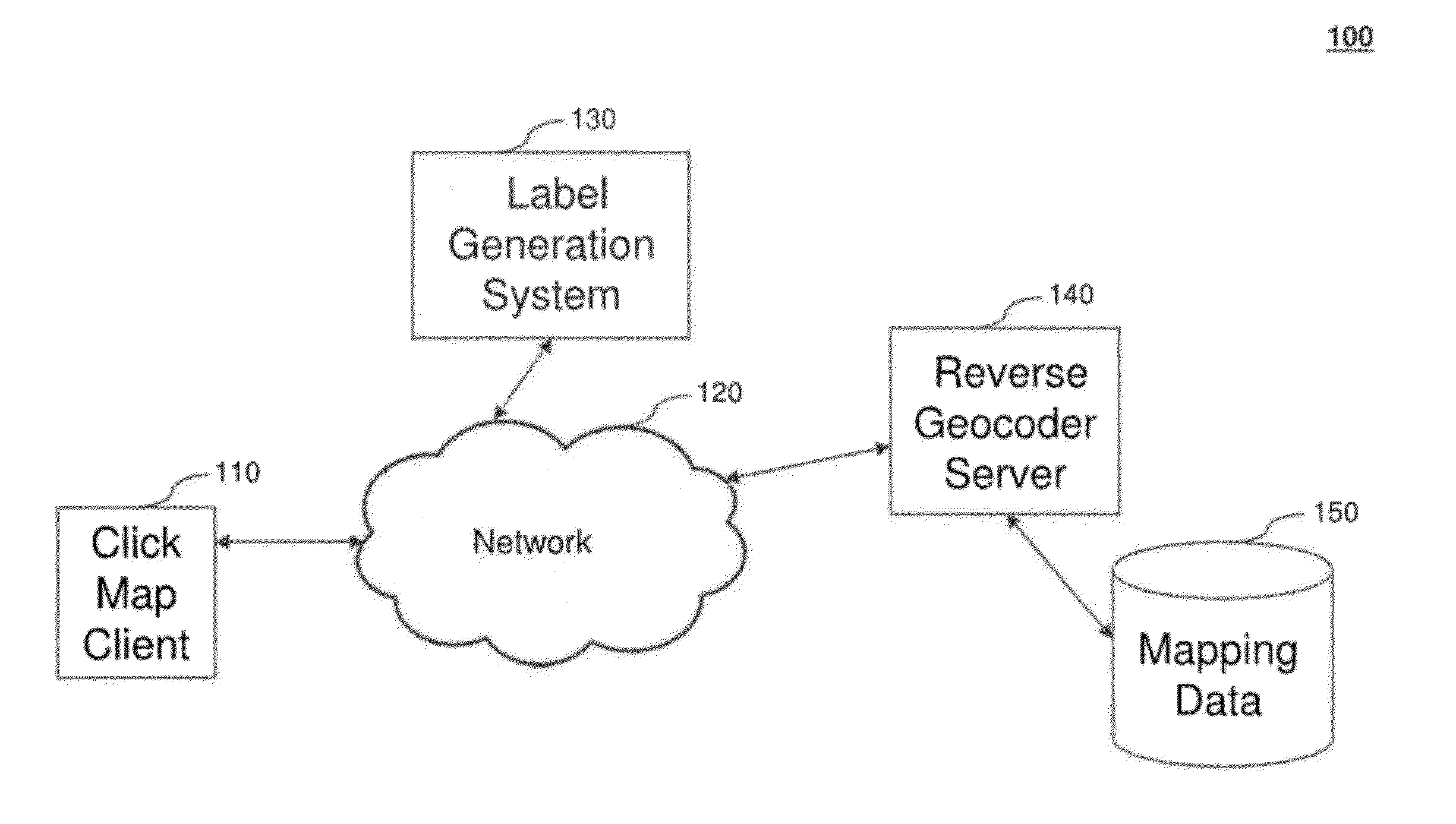
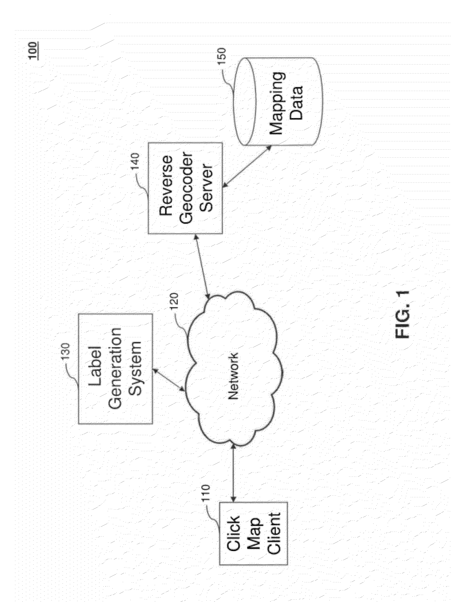
[0024]FIG. 1 is a diagram illustrating system 100 according to an embodiment of the present invention. System 100 includes a clickmap client 110, a network 120, a label generation system 130, one or more reverse geocoder server(s) 140, and a store of mapping data 150.

[0025]Clickmap client 110 communicates with label generation system 130 and one or more reverse geocoder servers 140, for example, across one or more networks 120, such as the Internet or a local area network. Server(s) 140 may serve mapping data including geographic information, e.g., geographic layer data, to clickmap client 110 and / or label generation system 130 based on mapping data 150.

[0026]Clickmap client 110 presents a visual representation of a map to a user. In an embodiment the user can enter a desired address to be presented in a map format. Once the mapped location is presented using clickmap client 110, the user can customize the presented map with one or more labels identifying selective locations on the ...


PUM


Abstract

Embodiments of the present invention relate to providing a method for creating customized labeled maps that include displaying a map using a presentation device based on a selectable elevation value, where the map contains geocoded information and the user selects at least one position on the displayed map. The method continues by automatically creating and displaying at least one label located in proximity to the selected position, where at least one label is based on reverse geocoded information associated with the selected position.

Description

BACKGROUND[0001]1. Field[0002]Embodiments of the present invention relate to generating and customizing maps.[0003]2. Background[0004]A geographic information system (GIS) is used to store, retrieve, and manipulate data that has been stored and indexed according to geographic coordinates. Typical geographic information systems support the display of information associated with specific geographic coordinates where such information is categorized into various layers representing differing levels of detail. Such information can represent such detail as specific addresses at a low layer level and at higher levels data such as the name of the neighborhood, the associated city, county, state, and country.[0005]A user of such geographic information may desire to create a customized map showing a particular feature or highlighting selective information associated with a select area. For example, a television news team may wish to show a map of an area that contains a river that is about to...

Claims


Application Information

Patent Timeline
Patent Type & Authority Applications(United States)
IPC IPC(8): G09G5/00
CPCG09B29/106G09B29/006
Inventor KUHNE, STEFAN
Owner GOOGLE LLC
Why Eureka
Try Eureka